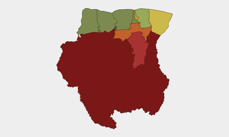
Situation Summary
Suriname remains a low–threat operating environment globally (rank #87, composite score 12) with no confirmed security incidents, civil unrest, or infrastructure failures documented in the last 24–48 hours. However, sub-national risk is heavily concentrated in the interior and eastern border regions, driven by illicit mining, narcotics trafficking, and limited state presence. The security picture is stable but remains fragmented between secure urban/coastal zones and high-risk remote territories.
Key Developments
No discrete security, conflict, crime, political instability, infrastructure, or travel-risk incidents have been corroborated in Suriname in the last 24–48 hours based on available open-source feeds and social media monitoring.
Note: If proprietary alert feeds (GardaWorld, Crisis24, Dataminr, or internal SOC platforms) indicate recent events, cross-reference those sources; low-visibility incidents in remote or interior regions may not surface in public OSINT streams.
Highest-Risk Areas
Sipaliwini District (risk 92) dominates the threat landscape and comprises the southern interior—a vast, sparsely populated region with minimal government control where illegal gold mining, cocaine transshipment, and arms trafficking are endemic. Brokopondo (78) and Para (74) districts follow, also interior zones with limited law enforcement and significant criminal activity. Paramaribo (71), the capital, carries elevated urban crime risk but remains substantially more stable than interior districts. The risk gradient reflects state capacity collapse in remote areas: coastal and northwestern zones (Nickerie, risk 8; Coronie, risk 12) remain lowest-risk, consistent with higher population density and government presence.
How GeoBit Would Assist
Corporate security teams operating in or transiting Suriname should employ AOI Monitoring & Early Warning on high-risk districts (especially Sipaliwini and Brokopondo) to detect trafficking activity, criminal group movements, or infrastructure disruption; Intel Sweep and multi-language OSINT to track narcotics and mining networks that may affect supply-chain or personnel security; and Routing & Network Analysis to plan safer transit corridors and alternative routes around interior conflict zones. Satellite & Imagery analysis can support site security assessments and supply-line vulnerability mapping in remote operating areas.
7-Day Outlook
No imminent escalation is forecast. Suriname's baseline stability is expected to hold, with risk remaining concentrated in interior districts where illicit activity occurs below the threshold of acute incident generation. Personnel and asset security in Paramaribo and coastal zones will likely remain routine; duty-of-care focus should remain on supply-chain resilience and travel risk mitigation for any staff movement to or through interior regions.
Highest-Risk Areas — Ranked
| # | State / Region | Risk |
|---|---|---|
| 1 | Sipaliwini | 92 |
| 2 | Brokopondo | 78 |
| 3 | Para | 74 |
| 4 | Paramaribo | 71 |
| 5 | Marowijne | 68 |
| 6 | Commewijne | 42 |
| 7 | Wanica | 38 |
| 8 | Saramacca | 29 |
| 9 | Coronie | 12 |
| 10 | Nickerie | 8 |
Sources
Previous Daily Briefs
A new Suriname brief is written every day — each with its own risk map and downloadable CSV. Here's the last week; use the calendar to go further back.
📅 Browse every day by calendar →
Highlighted days have a brief. Tap a day for that day's map & analysis, or “csv” for that day's dataset ($5).
Atlas — our AI intelligence desk — emails them this snapshot personally. Nothing else, no list.