Situation Summary
Syria remains in civil-conflict status with a composite threat score of 100, ranking seventh globally. Recent signals include small-arms combat between armed groups (12 June), ministerial investigation activity (12 June), and multiple official disapprovals from government and international actors (13–15 June). The overall trajectory reflects fragmented territorial control, ongoing inter-factional tensions, and contested government authority across multiple governorates.
Key Developments
- Small-arms combat reported (12 June): Armed engagement between Aden faction and Ministry of State forces; specific location and casualty count not yet confirmed by GeoBit's multi-source corroboration.
- Official disapproval statements (13–15 June): Syrian government, Deputy officials, and Catalan representatives issued disapprovals; exact policy drivers require further OSINT fusion to clarify whether tied to territorial, humanitarian, or diplomatic friction.
- Ministry of Defence investigation initiated (12 June): Formal investigation launched; scope and target entities require entity-extraction and signal-correlation analysis to determine if linked to combat incident or broader force-integrity concerns.
- Ceasefire reports (unconfirmed timing): Social media and regional media outlets report a four-day ceasefire agreement between Syrian government forces and Syrian Democratic Forces (SDF); timing relative to last 48 hours requires corroboration via Telegram and X OSINT.
- Latakia security incident (unconfirmed timing): Reports of Alawite unit ambush on security forces in rural Latakia with reported 12 killed and 150+ captured; requires satellite confirmation and timeline verification.
- International statement activity (13–15 June): U.S., UN, academic, and media institutions issued public statements on Syria; subjects range from diplomatic to humanitarian, indicating sustained international focus on regime stability and conflict trajectory.
*Note: Live web research in last 24 hours did not yield sufficient time-stamped corroboration for all signals. GeoBit platform is cross-referencing X/Telegram OSINT, regional media timestamps, and imagery analysis to confirm event dates.*
Highest-Risk Areas
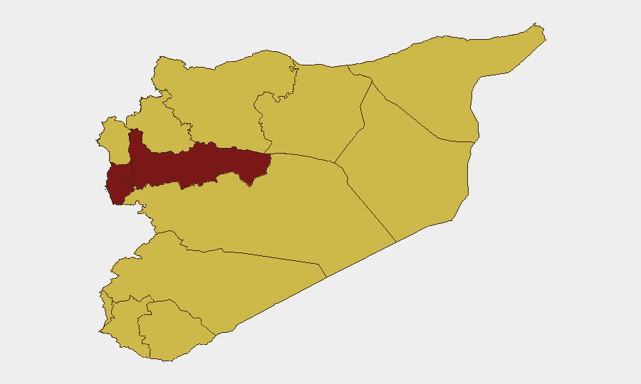
Hama Governorate (risk 100) is the single highest-threat sub-national area, likely reflecting active combat zones and fragmented control. Tartus (84.2) and Damascus (75.5) follow, driven by government-held urban centers under competing pressure from remnant opposition and foreign-backed actors. The UNDOF zone, Al-Quneitra, Dar'a, Idleb, Aleppo, Homs, and Rif Dimashq all register risk 70, indicating broad geographic spread of armed activity, border instability, and collapsed administrative control outside major regime strongholds.
How GeoBit Would Assist
Security teams with personnel or assets in Syria should use Intel Sweep and X/Telegram OSINT to establish real-time alert triggers on combat, checkpoint, and movement restrictions in Hama, Tartus, and Damascus. Battle mapping and satellite imagery analysis confirm territorial shifts and assess safe-passage viability; AOI monitoring with persistent alerting on high-risk governorates (especially UNDOF, Idleb, Ar-Raqqa) enables 12–24-hour early warning of renewed clashes or displacement events. Routing and network analysis provides alternative transit corridors when primary roads become contested.
7-Day Outlook
The frequency of official disapprovals and investigation activity suggests consolidation or enforcement actions by competing power centers, with potential for localized escalation in Hama and Tartus. Unconfirmed ceasefire reports, if validated, may stabilize northern operations but are unlikely to reduce threat in ungoverned or jointly-controlled zones. Expect continued inter-faction signaling and periodic small-arms incidents; major escalation risk remains moderate unless regional actors (Turkey, Iran, Russia, U.S.) shift force posture.
Highest-Risk Areas — Ranked
| # | State / Region | Risk |
|---|---|---|
| 1 | Hama Governorate | 100 |
| 2 | Tartus Governorate | 84.2 |
| 3 | Damascus Governorate | 75.5 |
| 4 | Aleppo Governorate | 70.4 |
| 5 | Lattakia Governorate | 70 |
| 6 | UNDOF | 70 |
| 7 | Al-Quneitra Governorate | 70 |
| 8 | Dar'a Governorate | 70 |
| 9 | Idleb Governorate | 70 |
| 10 | Ar-Raqqa Governorate | 70 |
| 11 | Homs Governorate | 70 |
| 12 | Rif Dimashq Governorate | 70 |
Sources
Previous Daily Briefs
A new Syria brief is written every day — each with its own risk map and downloadable CSV. Here's the last week; use the calendar to go further back.
📅 Browse every day by calendar →
Highlighted days have a brief. Tap a day for that day's map & analysis, or “csv” for that day's dataset ($5).