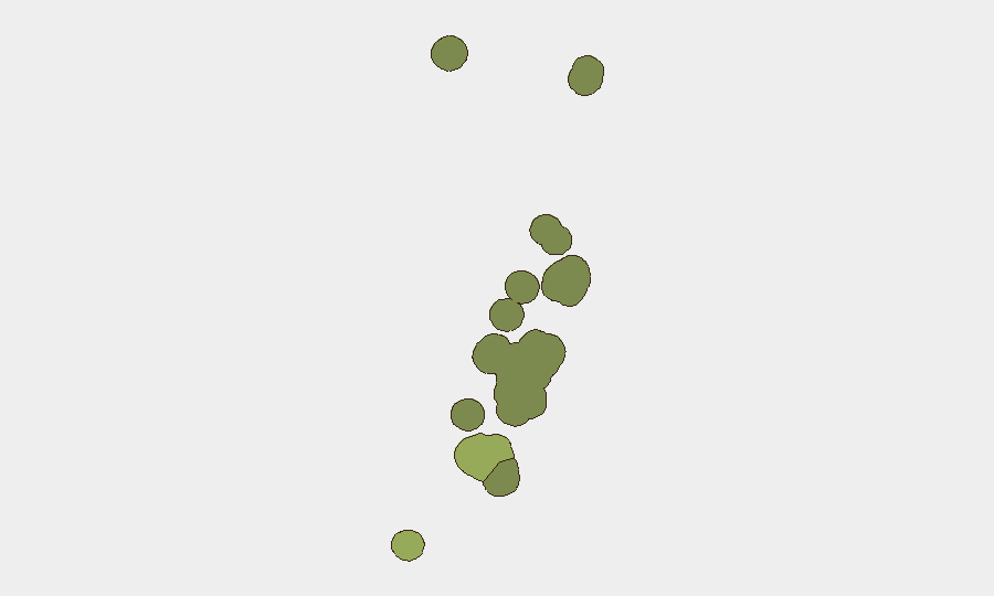
Situation Summary
Tonga remains a low-threat environment overall, with a composite threat score of 14 and no reported civil unrest, armed conflict, or infrastructure failures in the last 24–48 hours. A localized security incident—the ongoing manhunt for two foreign nationals who escaped Central Police Station in Nuku'alofa on or around 21 July—is driving heightened police activity and personal-security risk in Tongatapu, the country's highest-risk administrative division. Moderate seismic activity (four earthquakes, M 4.3–5.1) continues offshore with no confirmed impact on public safety or transport. The trajectory remains stable outside the prison-escape case.
Key Developments
- Nuku'alofa, Tongatapu – 24 July 2026: Police Commissioner Jeff Turner announced a TOP$5,000 reward per fugitive and reiterated that the two remaining escapees are high-risk and dangerous; emergency reporting numbers were provided, signaling sustained law-enforcement intensity around the manhunt.
- Nuku'alofa / Mataki'eua area, Tongatapu – 21 July 2026 (update carried into 24–25 July reports): One of three escapees was recaptured in the early hours; two remain at large and are described as linked to passport fraud and organized crime investigations with transnational elements.
- Nuku'alofa, Tongatapu – 24–25 July 2026 (ongoing): Tonga Police are coordinating with regional partners (New Zealand, Fiji) to locate the fugitives; increased police presence and checkpoint activity are visible in and around the capital.
- Offshore waters, Tonga archipelago – recent days (confirmed within last 24–48h): Four moderate earthquakes (M 4.3–5.1) recorded near Pangai, Houma, and surrounding waters; no tsunami warnings, damage reports, or transport disruptions issued.
- Nationwide – last 24–48 hours: No verified reports of civil unrest, protests, political instability, mass-casualty incidents, or changes to national travel advisories; routine crime remains within normal parameters outside the prison-escape operation.
Highest-Risk Areas
Tongatapu is the dominant risk driver (composite score 45), primarily due to the active manhunt and police operations centered in and around Nuku'alofa. Vavaʻu (score 28) carries moderate residual risk reflecting regional crime patterns and seismic activity; Haʻapai (score 22) reflects similar seismic and routine-crime exposure. The remaining divisions—ʻEua and Ongo Niua—carry minimal current risk. Corporate security teams with personnel or assets in the Nuku'alofa urban area should anticipate increased police visibility, possible checkpoints, and heightened awareness of unfamiliar persons, though the broader population-safety and business-continuity outlook remains stable.
How GeoBit Would Assist
Teams managing duty-of-care obligations in Tonga should deploy AOI Monitoring & Early Warning on Nuku'alofa and key transport hubs to detect any escalation in police activity or civil unrest; Intel Sweep and OSINT fusion to track regional law-enforcement coordination and fugitive-related intelligence; and Routing & Network Analysis to identify alternative movement corridors if checkpoints intensify. Satellite & Imagery analysis can monitor seismic risk zones and critical infrastructure for any secondary damage, while Maritime & Aviation tracking provides real-time visibility into ports and airfields for evacuation contingency planning.
7-Day Outlook
The prison-escape manhunt will likely remain the dominant security event in Tonga over the next seven days, with continued police operations and possible apprehension of the remaining fugitives. Seismic activity is expected to remain moderate and pose no confirmed public-safety risk. No political, civil-order, or infrastructure instability is forecast, and the overall security posture is expected to remain low outside the localized law-enforcement incident.
Highest-Risk Areas — Ranked
| # | State / Region | Risk |
|---|---|---|
| 1 | Tongatapu | 45 |
| 2 | Vavaʻu | 28 |
| 3 | Haʻapai | 22 |
| 4 | ʻEua | 18 |
| 5 | Ongo Niua | 12 |
Sources
Previous Daily Briefs
A new Tonga brief is written every day — each with its own risk map and downloadable CSV. Here's the last week; use the calendar to go further back.
📅 Browse every day by calendar →
Highlighted days have a brief. Tap a day for that day's map & analysis, or “csv” for that day's dataset ($5).
Atlas — our AI intelligence desk — emails them this snapshot personally. Nothing else, no list.