Situation Summary
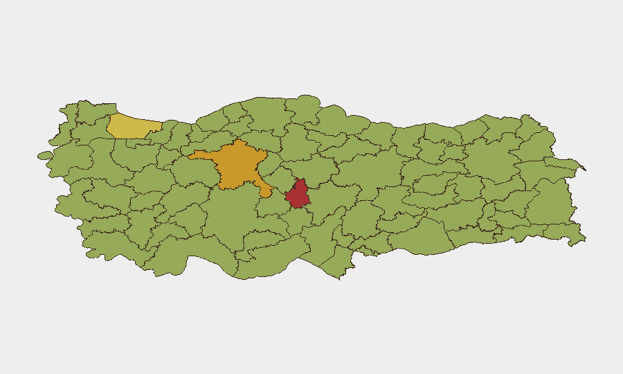
Turkey maintains a composite threat score of 68 (ranked #25 globally) driven by ongoing diplomatic friction, labor unrest, and parliamentary tensions rather than acute security incidents. Live open-source monitoring over the past 24–48 hours has not surfaced corroborated, timestamped incidents (unrest, crime, infrastructure disruption, or travel incidents) within Turkey's borders, indicating an information gap in English-language reporting rather than confirmation of stability. The security posture is characterized as elevated background risk rather than imminent crisis, with highest concentrations of tracked activity in major urban centers.
Key Developments
- 2026-06-19 · Conventional Military Force Activity — Qatar and Turkey engagement reported; no details on location or nature of interaction available in current OSINT feeds.
- 2026-06-18 · Labor Action — Strike/boycott activity reported involving Turkish workers; specifics on sector, location, and scale not yet corroborated in English-language sources.
- 2026-06-18 · Multi-Vector Diplomatic Disapproval — Turkey issued or received multiple expressions of disapproval, including toward the European Parliament and Greece; reflects heightened rhetorical tension in diplomatic channels rather than physical security threat.
- 2026-06-18 · Parliamentary Rejection — Turkish Parliament rejected a legislative or policy item; domestic political friction ongoing.
- 2026-06-17 · Cyprus–Turkey Rejection — Cyprus rejected a Turkish position or proposal, consistent with long-standing bilateral maritime and territorial disputes.
- Cyber-Risk Reminder (Istanbul) — A Central Bank of Libya breach attributed to an employee's use of unsecured hotel Wi-Fi in Istanbul (incident March 2026, disclosed June 2026) underscores persistent threat of rogue hotspot attacks against travelers in Turkish hospitality and public spaces.
- Maritime-Security Diplomacy — Turkish foreign minister recently urged Russia to avoid destabilizing steps in the Black Sea; no new maritime incidents off Turkish coast reported in the last 48 hours, but reflects ongoing geopolitical attention to navigation and regional security.
Highest-Risk Areas
Nevşehir (77.4), Ankara (71), and Istanbul (63.5) are the three highest-risk regions, with Istanbul's elevation driven by its role as a major transport hub, diplomatic seat, and tourism center where incidents (crime, protest, terrorism, or cyber risk) carry disproportionate impact. Ankara's risk reflects political volatility and proximity to government decision-making; Nevşehir's elevation warrants further investigation into local drivers (tourism, migration, sectarian, or economic). A second tier—Bursa, Izmir, Antalya, Denizli, Gaziantep, and Adana—shows sustained moderate-to-elevated risk, suggesting broad geographic distribution of vulnerability rather than single hotspot concentration.
How GeoBit Would Assist
Security teams monitoring personnel and assets in Turkey should task Intel Sweep and multi-language OSINT (Turkish-language media, municipal notices, transportation-operator alerts) to capture micro-level incidents (localized crime, protests, service disruptions) not yet surfaced in English reporting. AOI Monitoring & Early Warning on Istanbul, Ankara, and Nevşehir with real-time alerting on protest, labor, cyber, or travel-disruption signals would reduce response lag. Routing & Network Analysis and Risk & Threat Assessment capabilities help identify alternative travel corridors and employee movement protocols in high-risk zones.
7-Day Outlook
No imminent acute crisis is signaled; however, diplomatic and labor tensions remain elevated. If incidents materialize, Istanbul, Ankara, and Nevşehir are statistically most likely impact zones. Continued monitoring of parliamentary activity, EU/Greece relations, and labor organizing is warranted; absence of corroborated incidents in English sources does not guarantee stability at street level.
Highest-Risk Areas — Ranked
| # | State / Region | Risk |
|---|---|---|
| 1 | Nevşehir | 77.4 |
| 2 | Ankara | 71 |
| 3 | Istanbul | 63.5 |
| 4 | Bursa | 54.4 |
| 5 | Izmir | 53.8 |
| 6 | Malatya | 51.7 |
| 7 | Adana | 49.5 |
| 8 | Denizli | 49.5 |
| 9 | Isparta | 48.5 |
| 10 | Antalya | 48.5 |
| 11 | Gaziantep | 47.9 |
| 12 | Bayburt | 47.9 |
Sources
Previous Daily Briefs
A new Turkey brief is written every day — each with its own risk map and downloadable CSV. Here's the last week; use the calendar to go further back.
📅 Browse every day by calendar →
Highlighted days have a brief. Tap a day for that day's map & analysis, or “csv” for that day's dataset ($5).