Situation Summary
Ukraine remains under sustained Russian military pressure across multiple fronts, with active drone and conventional strikes targeting both military and civilian infrastructure nationwide. The overnight 10–11 June mass drone campaign across Kharkiv, Chernihiv, Odesa, and Dnipropetrovsk oblasts marks the latest in a pattern of systematic strikes on energy and transport networks, compounding logistics and civilian disruption. Ground combat continues with intensity in eastern Donetsk and northern Kharkiv sectors; concurrently, Ukrainian long-range strikes deep into Russian territory (Cheboksary, 9–10 June) signal capability to degrade Russian drone production. The conflict trajectory remains kinetically active with no near-term de-escalation indicators.
Key Developments
- Kharkiv oblast, night of 10–11 June 2026: Russian Shahed and loitering-munition strike wave impacted residential, industrial, and railway infrastructure; local power outages reported across the region.
- Chernihiv oblast, night of 10–11 June 2026: Russian drone and decoy-munition strikes damaged civilian and administrative infrastructure at multiple locations.
- Odesa oblast, night of 10–11 June 2026: Russian long-range drone and loitering-munition strikes struck civilian and industrial facilities; regional power grid disrupted per Ukrainian Air Force and Ministry of Energy.
- Dnipropetrovsk oblast, night of 10–11 June 2026: Residential and industrial damage and electricity outages reported following Russian drone strikes.
- Multi-regional power outages, 10 June 2026: Ukrainian Ministry of Energy confirmed energy infrastructure damage and outages across Donetsk, Zaporizhia, and Kherson oblasts from Russian attacks.
- Kostyantynivka area, Donetsk oblast, 10 June 2026: Ukrainian military observers reported Russian tactical advances in eastern and central urban zones; Ukrainian clearing operations underway against infiltrators in Dovha Balka district—sustained urban combat risk.
- Northern Kharkiv oblast / Velykyi Burluk sector, 10 June 2026: Russian offensive ground operations continued without confirmed territorial gains; border-region conflict intensity remains elevated.
- Cheboksary, Russian Federation, night of 9–10 June 2026: Ukrainian FP-5 Flamingo cruise-missile strike targeted VNIIR-Progress military plant (>900 km from front line), a facility producing Shahed-type drone and missile components; Russia acknowledged the strike.
Highest-Risk Areas
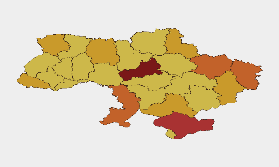
Cherkasy Oblast ranks highest (risk 100), followed by Kyiv (90.3) and Crimea (78.2); however, the 24-hour event pattern underscores heightened volatility in Kharkiv, Odesa, and Dnipropetrovsk oblasts, all struck in the 10–11 June campaign. Donetsk remains the ground-combat epicenter with Kostyantynivka experiencing active urban operations. Northern and eastern border zones (Kharkiv, Sumy, Chernihiv) face ongoing Russian ground pressure and airstrikes. The mass drone strikes of 10–11 June demonstrate Russia's ability to coordinate nationwide infrastructure targeting, elevating risk for any location with power-grid dependencies or transport networks.
How GeoBit Would Assist
Corporate security teams should deploy AOI Monitoring & Early Warning on sites in Kharkiv, Odesa, Donetsk, and Kyiv to detect drone strikes, power outages, and ground-force movements in near real-time. Routing & Network Analysis capabilities enable identification of alternative supply and evacuation routes when primary infrastructure (rail, power, roads) is disrupted by strikes. Conflict & Military battle mapping and force-structure tracking paired with OSINT fusion (X, Telegram, Ukrainian military statements) provide early signals of tactical shifts and allow duty-of-care teams to pre-position contingency measures before cascading strikes.
7-Day Outlook
Russian drone and missile strikes are expected to continue on a 2–5 day cycle targeting energy and transport infrastructure; power outages and logistical friction will persist as baseline operational conditions. Ground-combat intensity in Donetsk and northern Kharkiv is likely to remain high. Ukrainian counter-strikes on Russian military production (Cheboksary precedent) may prompt Russian retaliation escalation, particularly against Kyiv and western-facing oblasts.
Highest-Risk Areas — Ranked
| # | State / Region | Risk |
|---|---|---|
| 1 | Cherkasy Oblast | 100 |
| 2 | Kyiv | 90.3 |
| 3 | Autonomous Republic of Crimea | 78.2 |
| 4 | Kharkiv Oblast | 75.4 |
| 5 | Odesa Oblast | 75 |
| 6 | Luhansk Oblast | 73.8 |
| 7 | Sumy Oblast | 72.9 |
| 8 | Kherson Oblast | 72.9 |
| 9 | Donetsk Oblast | 72.8 |
| 10 | Zhytomyr Oblast | 71.7 |
| 11 | Zakarpattia Oblast | 71.2 |
| 12 | Volyn Oblast | 71 |
Previous Daily Briefs
A new Ukraine brief is written every day — each with its own risk map and downloadable CSV. Here's the last week; use the calendar to go further back.
📅 Browse every day by calendar →
Highlighted days have a brief. Tap a day for that day's map & analysis, or “csv” for that day's dataset ($5).