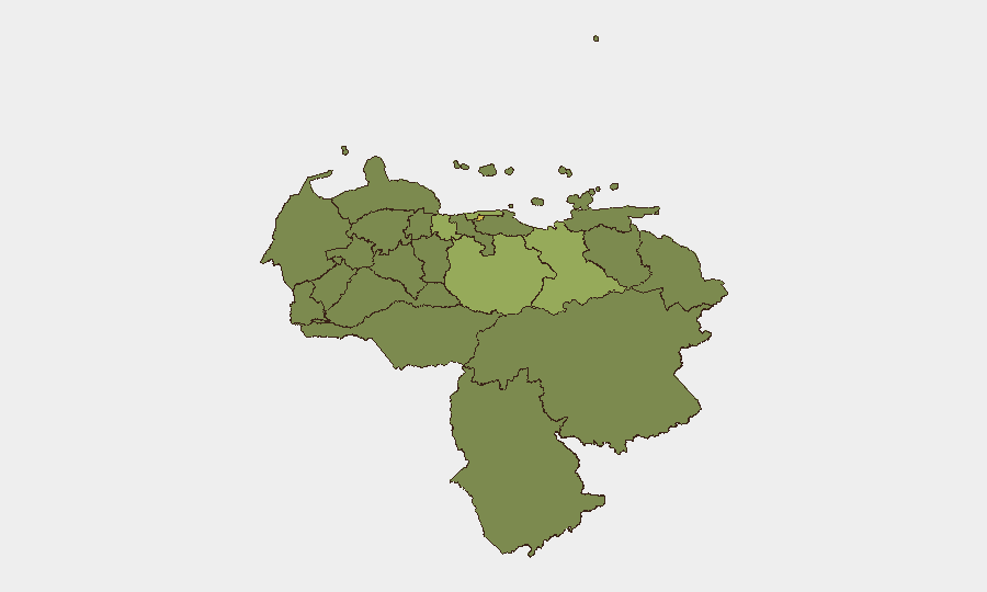
Situation Summary
Venezuela's security environment has been dramatically altered by the occurrence of two major earthquakes (magnitudes 7.2 and 7.5) on 24 June 2026 off the northern coast, which have killed at least 235 people, injured over 4,300, and caused widespread infrastructure collapse in the La Guaira and Caracas regions. The government has declared a national state of emergency, granting expanded executive authority for disaster response and security operations. The composite national threat score remains at 50 (rank #38 globally), but the earthquake and resulting humanitarian crisis have introduced acute cascading risks—airport closure, communications disruption, displaced populations, and constrained security-force mobility—that will dominate the operational environment for the coming weeks.
Key Developments
- La Guaira & Maiquetía coastal corridor (24–25 June 2026): Twin earthquakes (7.2 and 7.5 magnitude) struck off the northern coast west of Caracas, destroying buildings, killing at least 235 people, and injuring 4,300+; ongoing search-and-rescue operations are hampered by aftershock risk and collapsed infrastructure.
- Simón Bolívar International Airport, Maiquetía (24–25 June 2026): Venezuela's primary international airport sustained structural damage and has been closed until further notice, severely disrupting humanitarian logistics, business operations, and evacuation routes.
- Caracas & central neighborhoods (24–25 June 2026): Multiple residential and commercial buildings have collapsed or been structurally compromised; widespread power and communications outages are reported, with residents evacuating to open areas and makeshift shelters.
- National emergency declaration (24–25 June 2026): The Venezuelan government declared a nationwide state of emergency, enabling expanded executive powers for security, economic, and social measures in response to the earthquake.
- Transport infrastructure damage (24–25 June 2026): Roads, bridges, and rail services (including train services in Caracas) have sustained significant damage, increasing travel risk and slowing aid delivery and security operations across the northern coastal corridor.
- International disaster response activation (25 June 2026): The United States and other foreign governments have begun deploying urban search-and-rescue teams and humanitarian assistance to affected zones; officials note that the 72-hour critical window for rescue is underway and casualty figures are expected to rise.
Highest-Risk Areas
Federal District (risk 64.9), Guarico State (59.5), and Vargas State (52.2) represent the highest composite risks. The earthquake's epicenter and primary damage footprint fall directly within Vargas State (La Guaira/Maiquetía) and immediately adjacent to the Federal District (Caracas), meaning the two top-scoring risk regions are now experiencing acute humanitarian and infrastructure crises. Guarico State's elevated score reflects broader underlying instability; the earthquake's secondary effects—displaced persons, emergency-response strain, and reduced government capacity—will amplify existing criminality and governance gaps across all high-risk states over the coming weeks.
How GeoBit Would Assist
Organizations with personnel or assets in Venezuela should employ AOI Monitoring & Early Warning on Caracas, La Guaira, and key business/residential zones to track humanitarian access, infrastructure repair, and security-force positioning in real time. Routing & Network Analysis capabilities should be used to model alternative supply chains, evacuation corridors, and staff movement given airport closure and road damage. Intelligence & OSINT (Intel Sweep, sentiment analysis, and social-media monitoring) will provide early signals of aftershocks, secondary hazards, government policy shifts, or security deterioration in quake-affected zones.
7-Day Outlook
Rescue and debris-clearance operations will dominate the next 72 hours, with secondary aftershocks and infrastructure instability remaining high. Over 7 days, expect continued airport closure, disrupted communications, humanitarian bottlenecks, and localized security degradation as police and emergency services are redeployed to disaster zones. Organizations should anticipate extended supply-chain and personnel-mobility constraints and prioritize contingency planning.
Highest-Risk Areas — Ranked
| # | State / Region | Risk |
|---|---|---|
| 1 | Federal District | 64.9 |
| 2 | Guarico State | 59.5 |
| 3 | Vargas State | 52.2 |
| 4 | Anzoategui State | 41.3 |
| 5 | Carabobo State | 40.1 |
| 6 | Amazonas State | 38.2 |
| 7 | Barinas State | 36.1 |
| 8 | Aragua State | 35.9 |
| 9 | Miranda State | 35.6 |
| 10 | Trujillo State | 35.4 |
| 11 | Apure State | 35.2 |
| 12 | Tachira State | 35.2 |
Sources
Previous Daily Briefs
A new Venezuela brief is written every day — each with its own risk map and downloadable CSV. Here's the last week; use the calendar to go further back.
📅 Browse every day by calendar →
Highlighted days have a brief. Tap a day for that day's map & analysis, or “csv” for that day's dataset ($5).