Situation Summary
Togo remains at low global threat ranking (composite score 19), but faces a complex and regionally-inflected security environment driven by northern jihadist activity, reported foreign military deployments, and localized infrastructure disruption. No major kinetic incidents were reported inside Togo in the last 24–48 hours; however, political tensions have escalated over the presence of Russian Africa Corps and Turkish SADAT personnel in counter-insurgency operations in the Savanes region. Risk is heavily concentrated in the north and coastal prefectures, with the security posture shaped more by cross-border spillover and government response capacity than by direct internal conflict.
Key Developments
- Lomé, 21 July 2026 – Opposition and civil-society coalitions issued a public statement demanding government clarification on the deployment of Russian Africa Corps mercenaries and Turkish SADAT private military personnel in northern Togo, citing concerns over operational command, mandate, and scale of presence in the Savanes region counter-insurgency effort.
- Savanes Region, 21 July 2026 (referenced) – Opposition statement cited recent jihadist incursions in Savanes as the stated justification for foreign paramilitary deployments; exact dates of incursions not provided in available reports, but the political reaction and security concern are explicitly current.
- Vo, Zio, and Lacs Prefectures, 21–22 July 2026 – Togolese authorities confirmed detection of highly pathogenic avian influenza (H5N1) on five poultry farms, triggering animal-health containment measures with potential implications for rural trade, movement of goods, and livelihoods in affected coastal and central prefectures.
- Vo and Zio Prefectures, ongoing since mid-July – Emergency food assistance by state phosphate company SNPT continues for families recovering from heavy rains and flooding (29–30 June); infrastructure degradation and ongoing displacement remain relevant for logistics and personnel movement in these areas.
- Nigeria–Togo Border (Okuta, Kwara State), 22 July 2026 – Nigerian police reported arrest of two Togolese nationals (Yakubu Ismaila, Hadiza Kosia) in connection with a foiled kidnapping and extortion attempt; incident reflects cross-border crime activity relevant to wider border-zone travel security, though the incident occurred on the Nigerian side.
Highest-Risk Areas
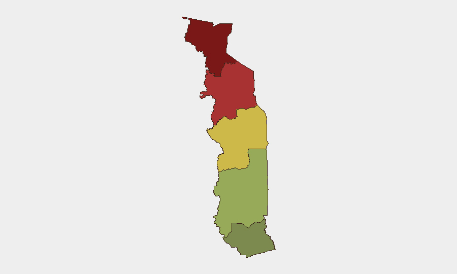
Savanes Region (risk 92) and Kara Region (risk 78) dominate the threat landscape, driven by active jihadist incursions, the recent influx of foreign military contractors, and political uncertainty over counter-insurgency command structures. Centrale Region (65) faces secondary risk tied to northern spillover and resource-constraint vulnerabilities. Maritime Region (28) is significantly lower-risk but faces localized disruption from H5N1 outbreak and infrastructure recovery from June flooding. Organizations with personnel or supply chains in the Savanes and Kara regions should implement heightened monitoring and contingency protocols; those in coastal prefectures should track H5N1 containment and infrastructure-recovery timelines.
How GeoBit Would Assist
GeoBit's AOI Monitoring & Early Warning and Conflict & Military capabilities enable continuous surveillance of the Savanes and Kara regions for changes in jihadist activity, foreign force positioning, and spillover risks. Intel Sweep and multi-language OSINT fusion track political and paramilitary developments in real time, corroborating opposition claims and government posture. Routing & Network Analysis identifies alternative travel corridors to avoid high-risk prefectures and border zones, while Environmental & Health monitoring flags disease outbreaks and infrastructure disruption affecting logistics and personnel mobility.
7-Day Outlook
Political friction over foreign military deployments is likely to persist without formal government clarification, potentially attracting further international scrutiny and civil-society pressure. Jihadist activity in the north is expected to remain episodic rather than large-scale; however, the presence of multiple armed actors (Togolese forces, foreign contractors, militant groups) increases risk of uncoordinated engagement or escalation. H5N1 containment measures should stabilize within 5–10 days if protocols are enforced; flood recovery in coastal areas will remain a friction point for logistics through mid-August.
Highest-Risk Areas — Ranked
| # | State / Region | Risk |
|---|---|---|
| 1 | Savanes Region | 92 |
| 2 | Kara Region | 78 |
| 3 | Centrale Region | 65 |
| 4 | Plateaux Region | 45 |
| 5 | Maritime Region | 28 |
Sources
Previous Daily Briefs
A new Togo brief is written every day — each with its own risk map and downloadable CSV. Here's the last week; use the calendar to go further back.
📅 Browse every day by calendar →
Highlighted days have a brief. Tap a day for that day's map & analysis, or “csv” for that day's dataset ($5).
Atlas — our AI intelligence desk — emails them this snapshot personally. Nothing else, no list.