Situation Summary
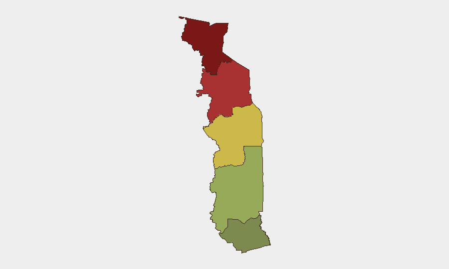
Togo remains a low-threat environment globally (composite risk score 23, rank #59), with no verified security events in the last 24–48 hours. However, significant geographic disparity exists: the northern Savanes and Kara regions carry substantially elevated risk (92 and 78, respectively), while the Maritime Region and capital Lomé remain comparatively stable. A cross-border arrest involving Benin warrants monitoring for implications on border security posture, though details remain limited.
Key Developments
- 2026-07-20 · Border / Arrest Event (Benin–Togo): An arrest or detention incident was reported involving nationals or assets spanning the Benin–Togo border. Full operational details are not yet available; escalation or diplomatic friction should be monitored.
- No other verified incidents met the 24–48 hour recency threshold as of this brief's preparation. Older reporting (late June–early July) included flood impacts in Greater Lomé and isolated community violence in Agoé Atsanvé, but these fall outside the current operational window.
Highest-Risk Areas
The Savanes and Kara regions (composite scores 92 and 78) dominate Togo's threat profile and should be the primary focus of duty-of-care protocols. Both are characterized by porous borders, limited state presence, and historically sporadic criminal and communal violence. The Savanes Region in particular remains vulnerable to transnational organized crime and intercommunal tensions. The Centrale and Plateaux regions (65 and 45, respectively) present moderate elevation over the national baseline, while the Maritime Region and urban Lomé corridor carry substantially lower risk and support the bulk of commercial and diplomatic activity.
Organizations with personnel or assets in the northern regions should maintain heightened situational awareness and contingency protocols.
How GeoBit Would Assist
Security and risk teams managing Togo operations should deploy AOI Monitoring & Early Warning for the Savanes and Kara regions to detect emerging incidents before they escalate, coupled with Intel Sweep and global event feeds to catch cross-border movements and security incidents in real time. OSINT fusion (X/Twitter, local media, and multi-language sources) would provide ground-truth verification of incidents and sentiment shifts, while GIS & Spatial Analysis would map specific high-risk corridors and safe-passage routing. Finally, Border & Disputed-Territory search and Network & Actor Analysis would support understanding of the Benin–Togo border dynamic and any organized crime or militant presence.
7-Day Outlook
No major escalation is anticipated in the near term; Togo's overall stability remains intact. However, the Benin–Togo border incident should be monitored for diplomatic or operational ripple effects. Northern regions will likely remain under baseline elevated risk, with seasonal weather and crop-cycle pressures potentially driving isolated communal tensions. Organizations should maintain routine vigilance and refresh contingency protocols, particularly for staff in Savanes and Kara.
Next Update: 2026-07-21 (or upon verification of significant incident).
Report Prepared: 2026-07-20 | Classification: Internal Corporate Use
Highest-Risk Areas — Ranked
| # | State / Region | Risk |
|---|---|---|
| 1 | Savanes Region | 92 |
| 2 | Kara Region | 78 |
| 3 | Centrale Region | 65 |
| 4 | Plateaux Region | 45 |
| 5 | Maritime Region | 28 |
Sources
Previous Daily Briefs
A new Togo brief is written every day — each with its own risk map and downloadable CSV. Here's the last week; use the calendar to go further back.
📅 Browse every day by calendar →
Highlighted days have a brief. Tap a day for that day's map & analysis, or “csv” for that day's dataset ($5).
Atlas — our AI intelligence desk — emails them this snapshot personally. Nothing else, no list.