Situation Summary
Togo remains a stable middle-tier risk environment (global rank #61) with a composite threat score of 23, driven primarily by underlying vulnerabilities in the northern Savanes and Kara regions rather than acute national-level instability. No clearly documented, multi-source-verified security incidents have been confirmed within Togo's borders during the last 24–48 hours; available OSINT reflects a reporting gap typical of some West African states in narrow surveillance windows, rather than an indicator of improved or deteriorated conditions. Armed activity and police detention events have been signaled in recent OSINT streams, but lack precise geographic and temporal corroboration sufficient to locate or time them reliably. The security posture remains consistent with medium-term structural vulnerabilities in border and administrative regions rather than acute crisis.
Key Developments
- Reporting Gap (16–18 July): No multi-source-confirmed security, conflict, civil-unrest, or crime incidents have been time-stamped and located within Togo during the last 48 hours; open-source and social monitoring indicate a short-term OSINT coverage gap rather than verified security changes.
- Armed Engagement Signal (2026-07-16): Small arms combat involving a junta actor was cited in event feeds; specific location and casualty data remain unconfirmed pending corroboration.
- Arrest Event (2026-07-17): Police detention of Togolese nationals was reported; jurisdiction, charges, and geographic location are not yet specified in available public sources.
- Official Public Statements (2026-07-17): Two separate public statements from a public relations officer or government spokesperson occurred on 17 July; content and context are not detailed in current OSINT.
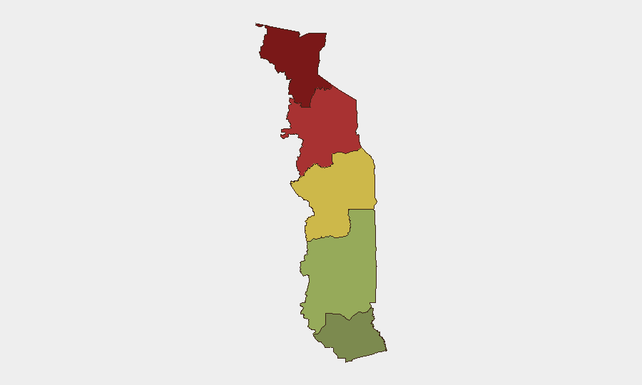
- Ongoing Northern Border Risk: Savanes Region (risk score 92) and Kara Region (risk score 78) continue to represent the highest sub-national threat concentrations, consistent with longer-term patterns of cross-border armed group activity and trafficking.
- Civil Protection Readiness (Agome-Glozou, Togo): A three-day U.S.–Togolese joint civil-protection exercise (Operation Lignite Coast 2026) involving Togo's National Civil Protection Agency concluded recently, simulating disaster response; this is a training activity, not a security incident.
Highest-Risk Areas
Savanes Region (north; risk 92) and Kara Region (north-central; risk 78) drive the majority of Togo's overall threat profile, reflecting persistent cross-border armed group infiltration, trafficking networks, and limited state administrative capacity in remote areas. Centrale Region (risk 65) presents moderate concern. Maritime Region (Lomé and coastal areas; risk 28) remains the lowest-risk sub-national zone and continues to host most commercial and expatriate activity. Northern vulnerability is linked to porous borders with Burkina Faso and Mali, where armed Islamist and criminal networks operate, rather than to domestically rooted insurgency.
How GeoBit Would Assist
Security and duty-of-care teams operating in Togo should deploy AOI Monitoring & Early Warning on Savanes and Kara regions to detect cross-border armed activity and trafficking incidents in real time. Intel Sweep and OSINT fusion across local media, X/Twitter, and Telegram would close reporting gaps and corroborate emerging incidents within 24–48 hours. GIS & Spatial Analysis and Routing & Network Analysis enable teams to identify safe transit corridors and alternative supply routes, while Conflict & Military force-structure tracking maintains visibility on armed group deployment and capability changes affecting operational security.
7-Day Outlook
Near-term trajectory remains stable at current threat levels; no acute national-level destabilizers are signaled. Northern border zones will likely experience continued low-level armed activity and trafficking consistent with underlying structural vulnerabilities. Expatriate and commercial operations in Maritime Region and central Lomé remain the lowest-risk footprint; risk concentration in the north argues for enhanced monitoring of personnel or assets in Savanes and Kara.
Highest-Risk Areas — Ranked
| # | State / Region | Risk |
|---|---|---|
| 1 | Savanes Region | 92 |
| 2 | Kara Region | 78 |
| 3 | Centrale Region | 65 |
| 4 | Plateaux Region | 45 |
| 5 | Maritime Region | 28 |
Sources
Previous Daily Briefs
A new Togo brief is written every day — each with its own risk map and downloadable CSV. Here's the last week; use the calendar to go further back.
📅 Browse every day by calendar →
Highlighted days have a brief. Tap a day for that day's map & analysis, or “csv” for that day's dataset ($5).
Atlas — our AI intelligence desk — emails them this snapshot personally. Nothing else, no list.