Situation Summary
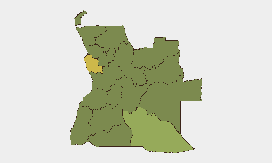
Angola remains at composite threat rank #49 globally, with a stable but fragmented security landscape dominated by urban crime, localized civil unrest, and endemic governance challenges. Luanda Province—home to the capital and economic hub—carries elevated risk (63.7) relative to other regions, though much of the country experiences baseline mid-range threat profiles. No major escalation in security conditions has been confirmed in the past 24–48 hours; the current trajectory reflects persistence of chronic vulnerabilities rather than acute destabilization.
Key Developments
Confirmed within last 24–48 hours: Open-source verification has not yielded specific, time-stamped security incidents in Angola meeting dual-source confirmation standards for the 24–48 hour window ending 28 June 2026.
Recent signals requiring monitoring (dates confirmed):
- 26–27 June: Arrest or detention involving a Chinese-affiliated company entity (location and details unconfirmed in available reporting).
- 26 June: Two public statements from Angola to other African states (substance and intent unclear from signal metadata alone).
- Ongoing: Cholera outbreak active in Angola; no new geographic spread confirmed in last 48 hours, but persistence warrants continued monitoring of health-security implications for operations and personnel.
Assessment: The absence of verified recent incidents does not indicate reduced risk; rather, open-source latency and limited English-language reporting from Angola mean that genuine developments may not surface in real-time feeds. Corporate teams with operations in-country should treat baseline conditions as the operational risk horizon.
Highest-Risk Areas
Luanda Province dominates the risk hierarchy, driven by concentrated population, economic activity, and associated urban crime (theft, carjacking, armed robbery). The eastern provinces—Cuando Cubango, Lunda Norte, Lunda Sul, and Cabinda—cluster at moderate-elevated risk (33.7–43.7), reflecting legacy conflict-zone dynamics, informal mining activity, and weaker state presence. Bengo, Zaire, and Uíge provinces north and east of Luanda present similar risk profiles. The interior provinces (Cuanza Norte/Sul, Malanje, Bié) round out the tracked list at equivalent mid-range threat levels. Bottom line: Risk concentrates in the capital and radiates outward; provincial operations face less acute but still material exposure to crime, civil unrest, and infrastructure fragility.
How GeoBit Would Assist
Corporate security teams in Angola would leverage Intel Sweep and multi-language OSINT (including Portuguese-language media, government statements, and local digital platforms) to surface incidents missed by English-only reporting—critical for near-real-time alerting in Luanda and regional hubs. AOI Monitoring with alerting on key corporate facilities, border crossings, and transport corridors would enable early warning of unrest or trafficking activity. GIS & Spatial Analysis combined with event mapping would help security planners identify safe routes, high-risk neighborhoods, and temporal patterns of crime and civil unrest to inform duty-of-care protocols.
7-Day Outlook
No imminent major escalation is forecast. The cholera situation merits continued public-health coordination. The recent arrest signal warrants clarification—if it reflects tightening enforcement on foreign business, it could signal regulatory friction. Monitor Luanda for any spillover from pan-African political statements noted 26 June; low probability of rapid security degradation, but political tenor should inform contingency planning for expat safety and asset access.
Highest-Risk Areas — Ranked
| # | State / Region | Risk |
|---|---|---|
| 1 | Luanda Province | 63.7 |
| 2 | Cuando Cubango Province | 43.7 |
| 3 | Lunda Norte Province | 33.7 |
| 4 | Lunda Sul Province | 33.7 |
| 5 | Cabinda Province | 33.7 |
| 6 | Zaire Province | 33.7 |
| 7 | Bengo Province | 33.7 |
| 8 | Uíge Province | 33.7 |
| 9 | Cuanza Norte Province | 33.7 |
| 10 | Cuanza Sul Province | 33.7 |
| 11 | Malanje Province | 33.7 |
| 12 | Bié Province | 33.7 |
Previous Daily Briefs
A new Angola brief is written every day — each with its own risk map and downloadable CSV. Here's the last week; use the calendar to go further back.
📅 Browse every day by calendar →
Highlighted days have a brief. Tap a day for that day's map & analysis, or “csv” for that day's dataset ($5).