Situation Summary
The Bahamas remains at a low national threat level (composite score 15) with no reported large-scale civil unrest, organized conflict, or critical infrastructure failures in the past 24–48 hours. However, violent street crime—including homicide and aggravated assault—continues at endemic baseline levels, concentrated in New Providence and Freeport. The security trajectory is stable but fragile; persistent gang and interpersonal violence, combined with ongoing high-profile corruption prosecutions, defines the operational risk environment for corporate and transient populations.
Key Developments
- Dundas Town, Abaco – nightclub shooting, mid-July 2026
A 32-year-old man was fatally ambushed by gunmen near a nightclub, reigniting local safety concerns and calls for closure of the venue over chronic security and noise violations.
- Nassau Village, New Providence – stabbing and arson death, mid-July 2026
Unionist Perry Cox was found dead with apparent stab wounds inside a burning duplex, with the local MP publicly condemning the killing and calling for non-violent conflict resolution; suspected arson.
- Magistrate's Court, Nassau – rape charge and remand, mid-July 2026
A 45-year-old Bahamian man was formally charged with rape and remanded to custody following court appearance, reflecting ongoing serious-crime caseload in the capital.
- Supreme Court, Nassau – corruption trial phase closed, mid-July 2026
Prosecutors concluded their case against former Water and Sewerage Corporation chairman Adrian Gibson and co-accused after two years of evidence presentation; retrial phase to follow. No associated civil unrest reported.
- Privy Council ruling on immigration detention – constitutional case reopened, mid-July 2026
The Privy Council sent the Jean-Rony Jean Charles constitutional case back to the Supreme Court, addressing detention and expulsion of a Bahamas-born national to Haiti; no protests or unrest documented.
- National-level stability – no new critical incidents, 24–48 hours
No discrete security incidents, infrastructure failures, or travel-risk developments identified beyond routine violent crime; security posture assessed as stable at baseline.
Highest-Risk Areas
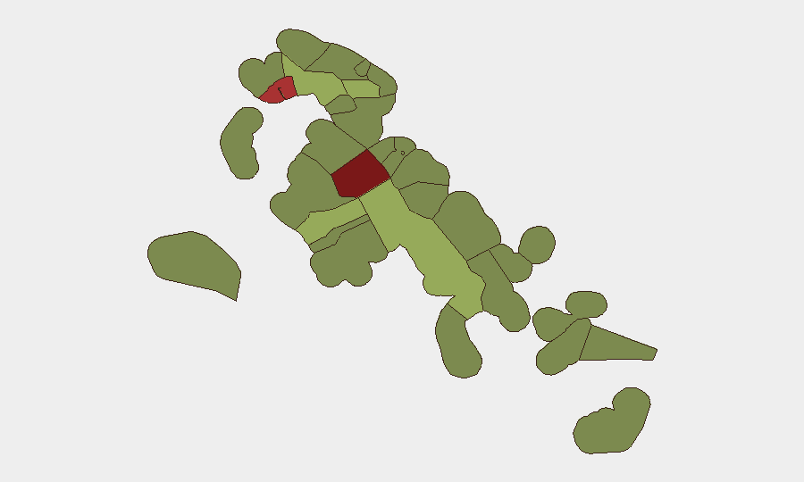
New Providence (risk 92) and Freeport (risk 78) dominate the sub-national risk ranking and account for the majority of violent crime, homicide, and gang activity in the archipelago. Central Abaco (risk 52) and Central Andros (risk 48) follow, driven by drug-trafficking networks and localized gang presence. The concentration of risk in three core urban centers—Nassau, Freeport, and Abaco—reflects established criminal infrastructure and limited law-enforcement capacity; corporate personnel and assets in these zones face elevated exposure to armed robbery, carjacking, and interpersonal homicide. Outer islands and southern regions remain lower-risk but are not crime-free.
How GeoBit Would Assist
Security teams operating in the Bahamas should deploy AOI (Area-of-Interest) Monitoring & Early Warning on New Providence, Freeport, and Central Abaco to receive real-time alerting on violent incidents, gang activity, and civil order disruptions affecting personnel movement and asset security. Intel Sweep and OSINT Fusion (X/Twitter, Telegram, local news feeds, and multi-language search) enable continuous monitoring of emerging threats, judicial developments, and community sentiment that may signal escalation. Routing & Network Analysis supports dynamic journey planning for staff and supply movements, identifying safer corridors and timing based on current crime and unrest patterns.
7-Day Outlook
No major escalation in civil unrest or organized conflict is anticipated over the next seven days; the security environment is expected to remain at endemic baseline-crime levels. Continued monitoring of the Gibson corruption trial and follow-on judicial proceedings is warranted, as high-profile convictions or acquittals may trigger localized community reaction. Personnel in New Providence and Freeport should maintain heightened situational awareness and adhere to standard security protocols for high-crime urban zones.
Highest-Risk Areas — Ranked
| # | State / Region | Risk |
|---|---|---|
| 1 | New Providence | 92 |
| 2 | City of Freeport | 78 |
| 3 | Central Abaco | 52 |
| 4 | Central Andros | 48 |
| 5 | Exuma | 45 |
| 6 | East Grand Bahama | 42 |
| 7 | South Andros | 38 |
| 8 | North Abaco | 35 |
| 9 | North Eleuthera | 33 |
| 10 | South Abaco | 32 |
| 11 | Cat Island | 30 |
| 12 | Mangrove Cay | 28 |
Previous Daily Briefs
A new Bahamas brief is written every day — each with its own risk map and downloadable CSV. Here's the last week; use the calendar to go further back.
📅 Browse every day by calendar →
Highlighted days have a brief. Tap a day for that day's map & analysis, or “csv” for that day's dataset ($5).
Atlas — our AI intelligence desk — emails them this snapshot personally. Nothing else, no list.