Situation Summary
Bahrain faces an acute military threat following Iranian missile and drone strikes against US military installations on 9 July 2026, triggering nationwide air-raid sirens and active air-defence intercepts. The kingdom's composite threat score of 24 (global rank #56) reflects escalating conventional military activity tied to broader US–Iran regional tensions rather than endemic instability. Northern and Southern Governorates carry substantially elevated risk (72 and 68 respectively), driven by proximity to potential cross-border fire and critical infrastructure concentration. The security posture remains on high alert with continued threat of secondary strikes and regional spillover.
Key Developments
- Manama and kingdom-wide (9 July, morning): Bahrain's Interior Ministry activated air-raid sirens across Manama and multiple areas, instructing civilians to seek safe locations as Iranian missiles and drones targeted US military facilities; sirens sounded three times over several hours, indicating successive waves or ongoing intercepts.
- Juffair US Naval Base and Sheikh Isa Air Base (9 July, early hours): Iran's military and Revolutionary Guards claimed direct strikes on these US-linked installations using missiles and kamikaze drones in retaliation for concurrent US airstrikes on Iranian targets; Bahrain Defence Force confirmed air-defence systems intercepted and destroyed multiple incoming projectiles.
- Nationwide airspace (9 July, early hours): Multiple explosions were reported across Bahrain following siren activations; authorities warned the public not to approach suspected debris from intercepts, indicating active air-defence engagement overhead civilian areas.
- Regional maritime and aviation (8–9 July): Iranian retaliatory operations simultaneously targeted US-linked infrastructure in Kuwait and Qatar; German Foreign Office updated travel advisory for Bahrain citing renewed airstrikes, air-traffic disruptions, and heightened abstract terrorist risk across the Gulf.
- Ongoing threat posture (as of 14 July): Bahrain Defence Force remains on high alert with no all-clear issued; public safety channels continue emergency guidance distribution; no ceasefire or de-escalation statement from Iranian or US officials has been confirmed in regional media.
Highest-Risk Areas
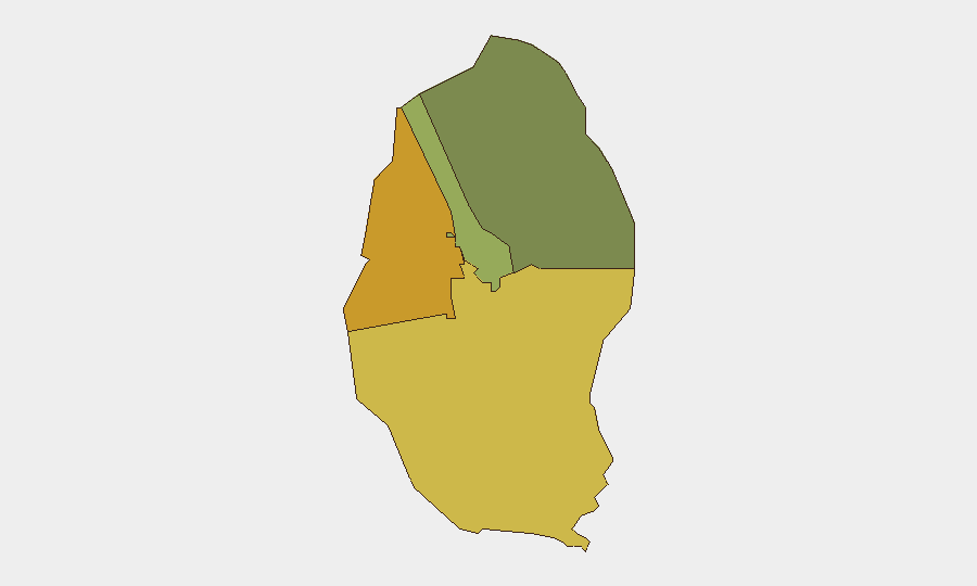
Northern Governorate (risk 72) and Southern Governorate (risk 68) dominate the sub-national ranking, reflecting their geographic exposure to cross-border fire from Iranian territory across the Persian Gulf and proximity to critical naval, air, and civilian infrastructure. Capital Governorate (risk 45) carries secondary but significant risk owing to Manama's role as the political and economic centre, where government, banking, and expatriate concentrations create both symbolic and material targets. Muharraq Governorate (risk 38), home to Bahrain International Airport and commercial shipping, faces aviation and maritime disruption risk. Risk declines sharply beyond these four zones, indicating threat concentration in the northern half of the archipelago.
How GeoBit Would Assist
Security teams would deploy Area-of-Interest Monitoring & Early Warning on Northern and Southern Governorates to detect subsequent Iranian activity, coupled with Intel Sweep and multi-language OSINT fusion to corroborate Iranian military claims and US response timelines in real time. Maritime & Aviation tracking combined with Routing & Network Analysis enable duty-of-care teams to identify safe corridors for staff movement and supply chains bypassing high-risk zones. Conflict & Military battle mapping and force-structure tracking provide situational clarity on Bahrain Defence Force readiness and US facility operational status, informing business continuity decisions.
7-Day Outlook
De-escalation remains uncertain; Iranian threats against "further action" and US carrier-group positioning in the Gulf suggest risk of secondary strikes within 7–10 days. Commercial aviation and port operations will likely remain disrupted or operate under heightened security protocols. Organisations should treat current high-alert posture as baseline and prepare for potential 48–72 hour operational disruptions.
Highest-Risk Areas — Ranked
| # | State / Region | Risk |
|---|---|---|
| 1 | Northern Governorate | 72 |
| 2 | Southern Governorate | 68 |
| 3 | Capital Governorate | 45 |
| 4 | Muharraq Governorate | 38 |
Sources
Previous Daily Briefs
A new Bahrain brief is written every day — each with its own risk map and downloadable CSV. Here's the last week; use the calendar to go further back.
📅 Browse every day by calendar →
Highlighted days have a brief. Tap a day for that day's map & analysis, or “csv” for that day's dataset ($5).
Atlas — our AI intelligence desk — emails them this snapshot personally. Nothing else, no list.