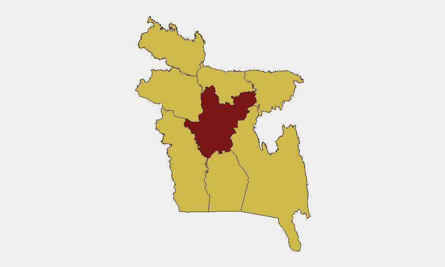
Situation Summary
Bangladesh remains at moderate global risk (#18 globally, composite score 97) with concentrated volatility in the capital region. A confirmed border confrontation on 27 June along the India–Bangladesh frontier, coupled with military mobilization signals and recent criminal armed violence in-country, indicate elevated tensions across security domains. Public health concerns (measles, Nipah virus) compound operational risk. The near-term trajectory is unstable but not critical.
Key Developments
- Bilbari / New Pallathal, Sribhumi district (India–Bangladesh border) — 27 June — Border Guard Bangladesh (BGB) confronted Indian Border Security Force (BSF) following an alleged pushback attempt. BGB reportedly issued warnings of potential escalation and threat of return fire. This represents the most substantiated recent security incident with direct operational impact on border zones.
- Military mobilization — 25 June — Official Bangladesh military mobilization signal issued; specific deployment locations and scale remain unconfirmed in available reporting. Warrants close monitoring for scope and duration.
- Small arms combat (criminal) — 26 June — Criminal-attributed armed violence reported; geographic specificity and casualty data not yet available from verification sources.
- Public statements (Bangladesh–China, Bangladesh–displaced populations) — 27 June — Official statements issued on both bilateral and internal displacement issues; context and intent require deeper source analysis to assess operational risk.
- Investigative action (Gazette) — 27 June — Formal investigation initiated; subject and jurisdiction unclear from current signals.
- Public health alerts (measles, Nipah virus) — recent — Two or more confirmed cases of Nipah virus infection and measles outbreak activity reported. Both pathogens pose secondary operational risk to expatriate and high-density workforce populations.
Highest-Risk Areas
Dhaka Division drives 97.6% of national risk and dominates the threat landscape, reflecting capital-region concentration of government, financial, and diplomatic infrastructure alongside urban density and criminal networks. All seven remaining divisions (Khulna, Barishal, Chittagong, Rangpur, Rajshahi, Mymensingh, Sylhet) register identical composite scores of 67.6, indicating either systemic underreporting outside the capital or uniform baseline risk across provincial zones. Border divisions—Rangpur (north), Sylhet (northeast), Chittagong (southeast)—warrant priority surveillance given the Bilbari incident and historical cross-border trafficking and militant activity.
How GeoBit Would Assist
Security teams should deploy AOI Monitoring & Early Warning on Dhaka Division and the India–Bangladesh border corridor (Sribhumi, Rangpur, Sylhet districts) to capture tactical incidents before escalation. OSINT fusion (Twitter/Telegram, multi-language news search, entity extraction) will disambiguate the military mobilization signal and track public statements for policy shifts. GIS & Spatial Analysis applied to criminal violence hotspots and health event clusters (Nipah, measles) enables risk-weighted routing and workforce deployment decisions; Routing & Network Analysis supports safe transit planning around Dhaka congestion and border zones.
7-Day Outlook
Border tensions are unlikely to escalate into sustained conflict absent major provocation, but localized skirmishes remain probable in Sribhumi and adjacent crossing zones. Military mobilization signals and criminal armed activity suggest tactical pressure within Bangladesh security apparatus; monitor official statements and troop movements for policy intent. Public health events are slow-moving but require 10–14 day horizon for outbreak tracking; implement screening protocols for high-density sites.
Highest-Risk Areas — Ranked
| # | State / Region | Risk |
|---|---|---|
| 1 | Dhaka Division | 97.6 |
| 2 | Khulna Division | 67.6 |
| 3 | Barishal Division | 67.6 |
| 4 | Chittagong Division | 67.6 |
| 5 | Rangpur Division | 67.6 |
| 6 | Rajshahi Division | 67.6 |
| 7 | Mymensingh Division | 67.6 |
| 8 | Sylhet Division | 67.6 |
Sources
Previous Daily Briefs
A new Bangladesh brief is written every day — each with its own risk map and downloadable CSV. Here's the last week; use the calendar to go further back.
📅 Browse every day by calendar →
Highlighted days have a brief. Tap a day for that day's map & analysis, or “csv” for that day's dataset ($5).