Situation Summary
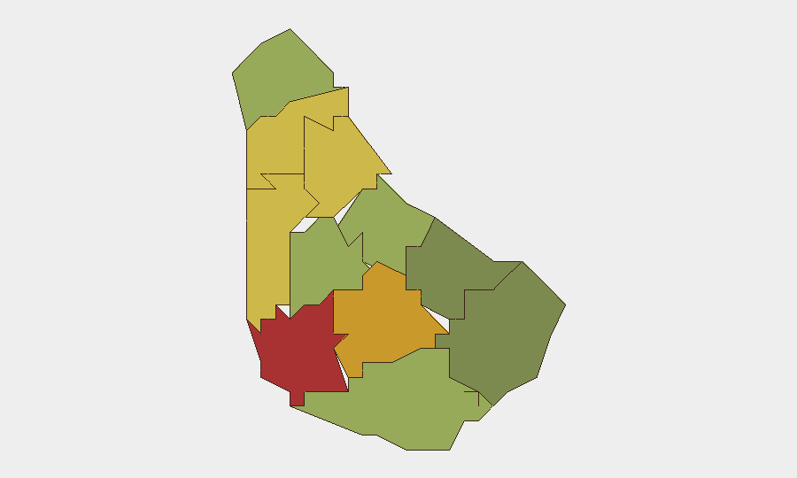
Barbados remains in a low-threat security posture overall, with no validated acute incidents (crime spikes, civil unrest, infrastructure disruption) detected in the prior 48 hours. The island is currently in a planned-security posture ahead of Crop Over festival activities, with heightened police and Defence Force presence concentrated in high-traffic areas. Saint Michael, Saint George, and Saint James parishes present elevated composite risk scores (78, 72, and 68 respectively), though these reflect baseline criminality patterns rather than current active incidents.
Key Developments
- Island-wide (27–28 Jul 2026): No validated acute security, civil-unrest, or infrastructure incidents reported in the 48-hour window; security operations remain planned and preventive rather than reactive.
- Bridgetown and island-wide (late Jul 2026): Barbados Police Service and Defence Force announced heightened Crop Over festival policing, including drone surveillance, CCTV monitoring, fixed checkpoints, traffic diversions, and rapid-response teams deployed through end of festival period.
- Island-wide (26–27 Jul 2026): Barbados Water Authority issued a cyber-fraud alert regarding a fraudulent TikTok account impersonating the agency and falsely offering bill-payment services; no financial or operational impact to water infrastructure confirmed.
- Christ Church (late Jul 2026, marginal timing confidence): Police opened an investigation into the death of 21-year-old Cammeron Ifill following a shooting incident; incident timing is near the edge of the 48-hour window and remains under investigation.
- Saint Michael / island-wide (ongoing): Baseline violent-crime activity continues at endemic levels; no spike or clustering above seasonal patterns detected in current brief period.
Highest-Risk Areas
Saint Michael (risk 78) and Saint George (risk 72) together account for the largest share of Barbados's composite risk exposure, reflecting persistent street-level and gang-affiliated violence, property crime, and drug-related incidents concentrated in urban Bridgetown and northern suburban parishes. Saint James (risk 68) adds secondary concern, particularly in tourism and business-district corridors. These three parishes have historically driven the majority of homicides and armed robbery on the island; current ranking reflects structural criminality rather than acute escalation, but corporate personnel and assets in these zones warrant sustained situational awareness and standard duty-of-care protocols.
How GeoBit Would Assist
Corporate security teams in Barbados would benefit from AOI (Area of Interest) Monitoring & Early Warning on Saint Michael, Saint George, and Saint James parishes to detect clustering of crime or protest activity; OSINT & Intel Sweep across local news, police radio, and social platforms to flag emerging incidents faster than official statements; and Routing & Network Analysis to identify safer travel corridors and alternative routes around checkpoint zones during festival periods. Sentiment & temporal analysis on Telegram, X/Twitter, and local forums can provide early signals of community friction or unrest before materialization.
7-Day Outlook
Crop Over festival activities will sustain elevated police presence and checkpoint operations through early August, raising both security and minor travel friction for corporate movement. No indicators suggest escalation of baseline crime or organized unrest during the festival window. Risk posture is expected to normalize by mid-August as festival operations conclude and security resources redeploy.
Highest-Risk Areas — Ranked
| # | State / Region | Risk |
|---|---|---|
| 1 | Saint Michael | 78 |
| 2 | Saint George | 72 |
| 3 | Saint James | 68 |
| 4 | Saint Andrew | 65 |
| 5 | Saint Peter | 62 |
| 6 | Saint Joseph | 58 |
| 7 | Saint Thomas | 52 |
| 8 | Saint Lucy | 48 |
| 9 | Christ Church | 42 |
| 10 | Saint John | 35 |
| 11 | Saint Philip | 28 |
Sources
Previous Daily Briefs
A new Barbados brief is written every day — each with its own risk map and downloadable CSV. Here's the last week; use the calendar to go further back.
📅 Browse every day by calendar →
Highlighted days have a brief. Tap a day for that day's map & analysis, or “csv” for that day's dataset ($5).
Atlas — our AI intelligence desk — emails them this snapshot personally. Nothing else, no list.