Situation Summary
Belarus remains at composite threat level 7 (global rank #null) with localized security pressures but no active armed conflict or large-scale instability inside the country as of 29 July 2026. Internal risk is concentrated in southern border regions adjacent to Ukraine, where Belarus has deployed heightened security measures and territorial defense exercises; simultaneously, Belarusian nationals and commercial transport face elevated cross-border risk from ongoing drone activity in Russian territory. Routine urban incidents (traffic collisions, minor public-order enforcement) and internal security measures (KGB terrorist-activities listings) reflect normal operational environment rather than systemic breakdown.
Key Developments
- Minsk, 28 July: Truck–passenger bus collision on city streets caused at least one injury; separate scooter–pedestrian crossing incident also resulted in injury. Both categorized as road-safety incidents with no security drivers.
- Minsk, 28–29 July: Police detained a Russian tourist near Nemiga metro station following a conflict; administrative case opened. Localized public-order response, no indication of wider unrest.
- Bryansk region, Russia (border-transit risk), recent 24–48 hours: Three Belarusian freight trucks damaged by Ukrainian drone strike; incident adds to pattern of cross-border commercial transport vulnerability. Belarus Security Council Secretary publicly urged Belarusians to avoid travel to Russia, citing drone threats and the 17 June bus attack on the Minsk–Anapa route.
- Southern Belarus–Ukraine border, ongoing: Belarusian Defense Ministry confirmed "strengthened security measures" and territorial defense exercises in border areas; official assessment remains "stable" with no detected Ukrainian offensive preparation.
- Belarus-wide, 26–27 July: KGB added 14 individuals to its official "terrorist activities" list, including three women. Reflects continuing internal security/political-repression operations affecting travel and asset access.
- Belarusian airspace, 20–26 July: Ukrainian monitoring reported 18 Russian drones detected in Belarusian airspace; Belarusian Air Force scrambled but no confirmed shootdowns or ground impact. Surveillance and military alerting ongoing, but no direct strikes.
Highest-Risk Areas
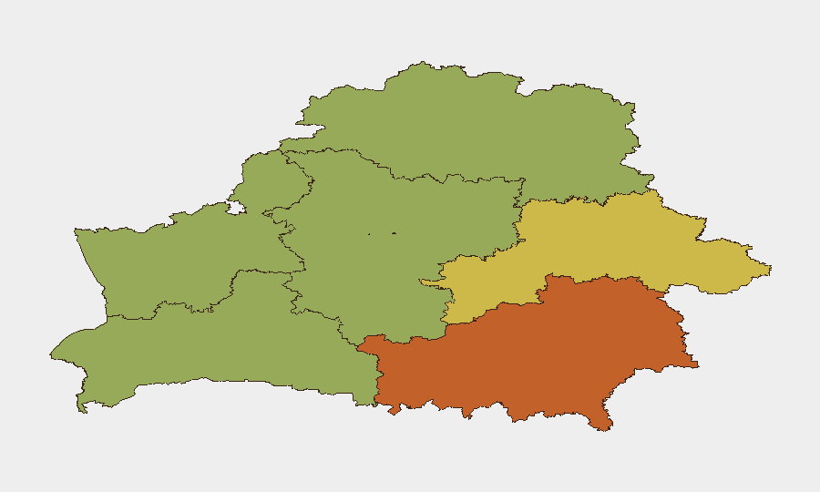
Homyel Region (risk 75) emerges as the highest-risk sub-national area, likely driven by proximity to both the Ukraine border and Russian territory used for drone operations and cross-border attacks. Minsk (risk 68) reflects routine urban hazards (traffic, petty crime, administrative detention) and concentration of police/security activity, while Mahilyow Region (risk 62) and Brest Region (risk 55) show secondary elevation linked to border militarization and cross-border security posture. Northern and western regions (Vitsebsk, Hrodna, Minsk Region) carry lower composite scores, indicating reduced conflict-related and cross-border risk.
How GeoBit Would Assist
Security teams with personnel or assets in Belarus should deploy Intel Sweep and multi-language OSINT (X/Twitter, Telegram, local incident feeds) for daily situational updates on border militarization, cross-border transport incidents, and internal security measures. AOI Monitoring & Early Warning on Homyel and southern border regions enables persistent watch for escalations in military activity or drone incursions. Routing & Network Analysis is operationally critical for teams planning transport across Belarus to Russia or Ukraine, identifying safer corridors and alternative routes around high-risk checkpoint and transit areas.
7-Day Outlook
No major escalation in internal instability is anticipated in the next seven days; however, cross-border risk to Belarusian nationals and commercial transport transiting Russia will remain elevated as long as Ukrainian drone operations continue in Bryansk and adjacent regions. Border militarization exercises are likely to continue as routine posturing. Duty-of-care teams should assume ongoing travel advisories against Russia and persistent internal security enforcement (KGB listings, border checks, administrative detention) as the baseline operational environment.
Highest-Risk Areas — Ranked
| # | State / Region | Risk |
|---|---|---|
| 1 | Homyel Region | 75 |
| 2 | Minsk | 68 |
| 3 | Mahilyow Region | 62 |
| 4 | Brest Region | 55 |
| 5 | Hrodna Region | 52 |
| 6 | Minsk Region | 48 |
| 7 | Vitsebsk Region | 45 |
Sources
Previous Daily Briefs
A new Belarus brief is written every day — each with its own risk map and downloadable CSV. Here's the last week; use the calendar to go further back.
📅 Browse every day by calendar →
Highlighted days have a brief. Tap a day for that day's map & analysis, or “csv” for that day's dataset ($5).
Atlas — our AI intelligence desk — emails them this snapshot personally. Nothing else, no list.