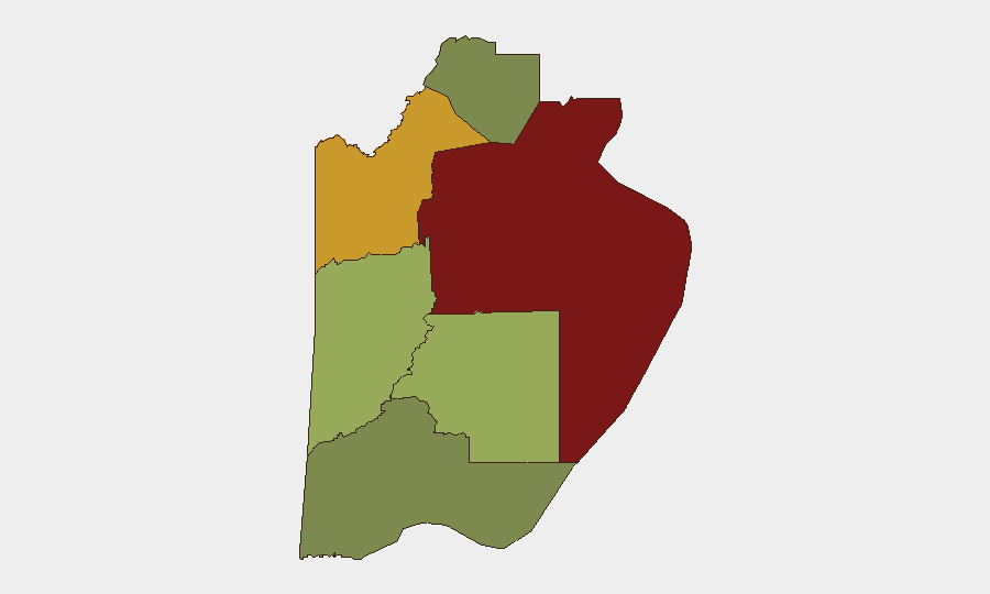
Situation Summary
Belize remains under elevated security stress, with Belize District driving national composite threat scores (rank 95 of 6 districts). Gang and cartel-linked violence—concentrated in Belize City and select inland areas—has persisted through late July 2026, marked by multiple shootings, armed robbery, and inter-faction conflict. Open-source reporting current to July 26 documents active armed incidents; no verified new events have been independently dated to July 30–31, 2026. The operating environment remains volatile, particularly in urban centers and Orange Walk District (rank 72).
Key Developments
Data Integrity Note: Open-source reporting available for this brief is current only to July 26, 2026. The following developments represent the most recent independently dated incidents:
- Unitedville Village, Cayo District (July 25–26, 2026): Triple shooting near village bus stop; one fatality (Denvoy Feliciano Bartley) at Western Regional Hospital; two others hospitalized; motive undetermined, no arrests reported.
- Belize City, Cemetery Road (July 26, 2026, morning): Shooting of 19-year-old construction worker Arnize Young by two assailants on motorcycle; injuries reported non-life-threatening.
- Belize City, Handyside Street (July 24, 2026): Armed robbery at Handy Side Loans and Pawn Shop; owner's son shot and wounded; investigation ongoing.
- Belize City, multi-neighborhood incidents (July 24, 2026): Three separate shooting incidents within 24 hours, including at least one double homicide; gang/inter-cartel conflict confirmed by police and intelligence sources.
- Belize District-wide (July 24, 2026): Intensified security-forces operations in gang-affected communities under State of Emergency framework.
No clearly dated incidents for July 30–31, 2026 have been independently verified in available open-source channels.
Highest-Risk Areas
Belize District (composite risk 95) dominates the threat landscape, driven by concentrated gang rivalry, cartel transit activity, and armed crime in Belize City and surrounding neighborhoods. Orange Walk District (risk 72) presents secondary concern, likely reflecting drug-trafficking corridor exposure and associated violence. Cayo District (risk 58) has shown recent incident activity (Unitedville shooting) but remains lower-ranked; peripheral districts (Stann Creek 48, Toledo 35, Corozal 22) carry substantially reduced exposure. Urban centers—particularly Belize City—warrant heightened duty-of-care attention for corporate personnel and asset movement.
How GeoBit Would Assist
Security teams should deploy AOI Monitoring & Early Warning on high-risk neighborhoods in Belize City and Orange Walk to receive real-time alerts on emerging incidents. Intel Sweep and multi-language OSINT fusion (including X/Twitter, Telegram, and local media) enable continuous tracking of gang activity, cartel movements, and police operations to anticipate flashpoints. GIS & Spatial Analysis and Routing & Network Analysis support safer journey planning and alternative transit corridors for personnel and asset movement, with persistent mapping of incident clusters and no-go zones.
7-Day Outlook
Absent material de-escalation signals, gang-linked violence in Belize District and Orange Walk is expected to remain at elevated levels through early August. State of Emergency operations may create short-term tactical disruptions to cartel logistics, but sustained reduction in violence typically requires weeks of enforcement. Corporate operations should maintain heightened situational awareness, restrict non-essential movement to high-risk districts, and coordinate with local security and diplomatic contacts for real-time incident reporting.
Highest-Risk Areas — Ranked
| # | State / Region | Risk |
|---|---|---|
| 1 | Belize District | 95 |
| 2 | Orange Walk District | 72 |
| 3 | Cayo District | 58 |
| 4 | Stann Creek District | 48 |
| 5 | Toledo District | 35 |
| 6 | Corozal District | 22 |
Sources
Previous Daily Briefs
A new Belize brief is written every day — each with its own risk map and downloadable CSV. Here's the last week; use the calendar to go further back.
📅 Browse every day by calendar →
Highlighted days have a brief. Tap a day for that day's map & analysis, or “csv” for that day's dataset ($5).
Atlas — our AI intelligence desk — emails them this snapshot personally. Nothing else, no list.