Situation Summary
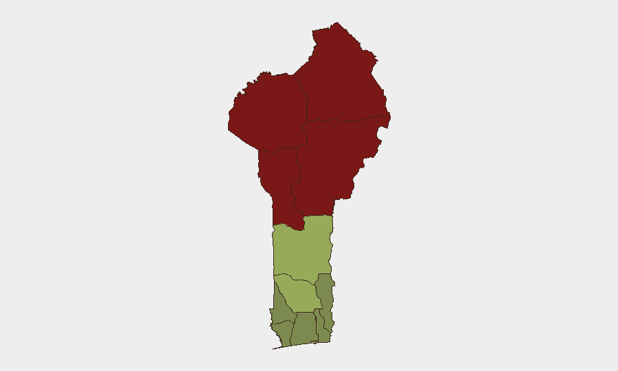
Benin remains a moderate-risk environment globally (rank #46; composite threat score 49) with active security event signals tracked over the past 72 hours, though verification of ground-truth developments is currently limited. The northern border departments—Alibori, Atakora, Donga, and Borgou—continue to drive elevated risk scores, reflecting persistent transnational pressures and non-state armed group activity in the Sahel region. Southern coastal and central departments remain substantially lower-risk. The overall trajectory is one of contained but persistent northern exposure rather than acute nationwide escalation.
Key Developments
- 2026-07-02 · Hostage/Abduction Incident (Lagos–Benin Cross-Border): GeoB event signals indicate an abduction or hijacking event with cross-border dimensions involving Lagos and Benin; specific location, actor, and victim details not yet verified from independent sources.
- 2026-07-02 · Official Statement (Benin–Africa Regional Level): Benin government or relevant authority issued a public statement with continental/African scope; content and context not confirmed in available web search within 24 hours.
- 2026-07-02 · Nigerian Cross-Border Activity (Nigeria–Benin): Event signal indicates an abduction/hijack event originating from or involving Nigerian actors and Benin territory; operational details require further corroboration.
- 2026-06-30 · Conventional Military Activity (West Bengal Region): An event flagged as conventional military force activity; geographic tag requires clarification, as West Bengal is a state in India; possible geocoding anomaly or regional SIGINT signal.
- 2026-07-02 · Demand Activity (West Bengal): A demand-type event signal; corroboration and scope unclear pending further intelligence.
Note: Web research over the last 24 hours has not independently verified real-time incident details from Benin media, ECOWAS security channels, or verified journalist accounts. Signals reflect GeoBit event-feed detection; ground truth assessment is pending.
Highest-Risk Areas
Northern Benin's Alibori, Atakora, Donga, and Borgou departments dominate the risk landscape (scores 83–92), driven by proximity to Burkina Faso and Niger, where Sahel-based non-state armed groups maintain operational presence and cross-border mobility. Zou Department (risk 45) shows moderately elevated exposure, likely reflecting spillover risk and supply-line interdiction. The southern and coastal belt—Ouémé, Littoral, Atlantique, and Mono—register substantially lower threat levels, indicating that security impact is concentrated in the landlocked north rather than distributed nationwide. This geography defines operational risk for personnel and asset positioning.
How GeoBit Would Assist
A corporate security team in Benin should employ AOI (Area-of-Interest) Monitoring & Early Warning on northern departments to capture cross-border incidents and armed group movement signals in real time with alerting thresholds. Intel Sweep, multi-language OSINT fusion, and X/Telegram monitoring would corroborate and contextualize event signals within 6–12 hours of occurrence, reducing fog in border regions. Routing & Network Analysis capabilities enable alternative journey planning away from high-risk corridors, while GIS & Spatial Analysis supports site-specific risk layering for asset placement and duty-of-care decisions.
7-Day Outlook
Near-term trajectory is likely to remain stable in the south and central belt, with continued low-level cross-border activity and armed group presence in the north. No indication of imminent nationwide escalation or political instability; however, isolated incidents in border zones should be expected as routine. Monitor for any official Benin government response statements or regional security force posture changes that may signal a shift in threat tempo.
Highest-Risk Areas — Ranked
| # | State / Region | Risk |
|---|---|---|
| 1 | Alibori Department | 92 |
| 2 | Atakora Department | 88 |
| 3 | Donga Department | 85 |
| 4 | Borgou Department | 83 |
| 5 | Zou Department | 45 |
| 6 | Collines Department | 42 |
| 7 | Plateau Department | 38 |
| 8 | Kouffo Department | 35 |
| 9 | Mono Department | 32 |
| 10 | Atlantique Department | 28 |
| 11 | Littoral | 25 |
| 12 | Ouémé Department | 22 |
Sources
Previous Daily Briefs
A new Benin brief is written every day — each with its own risk map and downloadable CSV. Here's the last week; use the calendar to go further back.
📅 Browse every day by calendar →
Highlighted days have a brief. Tap a day for that day's map & analysis, or “csv” for that day's dataset ($5).