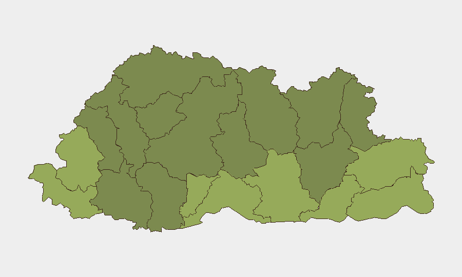
Situation Summary
Bhutan remains one of the world's lowest-risk countries, with no credible security incidents reported in the last 24–48 hours. The composite national threat score of 2 and zero tracked events reflect a stable security environment and effective law enforcement. However, sub-national risk concentration in southern border districts—particularly Samtse, Sarpang, and Haa—warrants continued monitoring by organizations with personnel or assets in those regions.
Key Developments
No discrete security incidents, civil unrest, infrastructure disruptions, or travel-risk events were independently confirmed in Bhutan during the 24–48 hour window ending 06 July 2026. Open-source news, social media monitoring, and regional digests yielded no reports of protests, cross-border clashes, terrorism, major crime, or formal travel advisory updates specific to Bhutanese locations or dates within this period.
Broader South Asian coverage mentioning Bhutan has focused on geopolitical and economic positioning (India–China influence competition, bilateral credit arrangements) rather than on-the-ground security incidents.
Highest-Risk Areas
Risk is heavily concentrated in Bhutan's southern border districts. Samtse (58), Sarpang (55), and Haa (52) carry the highest composite scores, likely reflecting proximity to international boundaries, historical cross-border activity, and trafficking corridors. Pemagatshel and Samdrup Jongkhar districts round out the top five. By contrast, central and northern districts (Lhuntse, Wangdue Phodrang, Gasa) register substantially lower risk. Organizations operating in the south should maintain baseline situational awareness and liaison with local authorities; those in Thimphu and the central valleys face minimal localized threat.
How GeoBit Would Assist
Security teams monitoring Bhutan should deploy AOI Monitoring & Early Warning on the five highest-risk southern districts to catch emerging incidents—protests, trafficking activity, or cross-border incidents—before they affect operations. Intel Sweep and multi-language OSINT (Dzongkha, English, regional sources) provide real-time visibility into local news, social media, and official announcements. Border & Disputed-Territory Search and Network & Actor Analysis help track unofficial movement, informal actors, and geopolitical shifts that may precede formal incidents. For personnel routing, Routing & Network Analysis identifies alternative transit corridors in southern districts to avoid choke points.
7-Day Outlook
No imminent security deterioration is forecast. Bhutan's political and law-enforcement institutions remain stable, and no regional flashpoints directly threaten the country in the near term. Duty-of-care teams should maintain standard vigilance in border districts and confirm staff awareness of local emergency contacts and procedures; no heightened alert posture is warranted at the national level.
Highest-Risk Areas — Ranked
| # | State / Region | Risk |
|---|---|---|
| 1 | Samtse District | 58 |
| 2 | Sarpang District | 55 |
| 3 | Haa District | 52 |
| 4 | Pemagatshel District | 50 |
| 5 | Samdrup Jongkhar District | 48 |
| 6 | Tsirang District | 45 |
| 7 | Zhemgang District | 42 |
| 8 | Trashigang District | 40 |
| 9 | Mongar District | 38 |
| 10 | Gasa District | 35 |
| 11 | Lhuntse District | 32 |
| 12 | Wangdue Phodrang District | 30 |
Previous Daily Briefs
A new Bhutan brief is written every day — each with its own risk map and downloadable CSV. Here's the last week; use the calendar to go further back.
📅 Browse every day by calendar →
Highlighted days have a brief. Tap a day for that day's map & analysis, or “csv” for that day's dataset ($5).
Atlas — our AI intelligence desk — emails them this snapshot personally. Nothing else, no list.