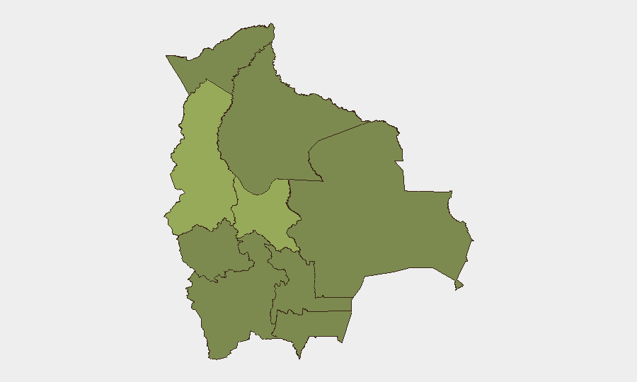
Situation Summary
Bolivia remains under heightened security tension, ranking #47 globally with a composite threat score of 37 across 64 tracked events. The security environment is characterized by periodic demonstrations, transport disruptions, and political friction, with Canada's travel advisory noting the situation could further deteriorate. No major security incidents have been corroborated in the last 24–48 hours; however, underlying drivers of instability—including civil unrest waves, peasant-landlord disputes, and political discord—remain active.
Key Developments
GeoBit's event signals for 2026-06-14 through 2026-06-16 include:
- 2026-06-16 · La Paz (inferred) – Presidential rejection of a proposal or measure; scope and details require local source verification.
- 2026-06-16 · National – Activist investigation initiated against government entities; nature and location require confirmation.
- 2026-06-16 · National – Domestic political disagreement between state actors (internal BOLIVIA vs BOLIVIA signal).
- 2026-06-16 · National – Government investigation ongoing; subject matter unconfirmed in open sources.
- 2026-06-15 · National – Public statement issued (Reuters-attributed); content not yet retrieved in available open web results.
- 2026-06-14 · Rural/Agricultural areas (inferred) – Violent protest or riot between peasant and landlord groups; location and casualties unconfirmed.
- 2026-06-14 · National – Public statement from Bolivian government regarding United States; content not yet retrieved.
Note on sourcing: GeoBit's event feed identifies these signals; however, open web and social-media sources have not yet provided detailed corroborating reports with specific locations, casualty counts, or incident context. Local Bolivian media, government statements, or closed-source feeds are required to validate scope and impact.
Highest-Risk Areas
La Paz (55.7) and Cochabamba (43.1) represent the primary drivers of national composite risk, reflecting concentration of political institutions, protest activity, and demonstration frequency in La Paz, combined with Cochabamba's history of labor and agrarian unrest. The remaining departments (Potosí, Tarija, Pando, Beni, Oruro, Chuquisaca, Santa Cruz) cluster at a lower but uniform risk level (25.7), suggesting broad underlying fragility without major localized flashpoints outside the western highlands. La Paz's dominance reflects its role as the administrative and political center; Cochabamba's significance lies in its agrarian and labor organizing capacity.
How GeoBit Would Assist
Security teams should use AOI Monitoring & Early Warning to establish persistent watches on La Paz, Cochabamba, and departmental capitals for protest announcements, roadblock alerts, and government statements; multi-language Search & Research (Spanish-language news, local social media, and X/Telegram monitoring) to identify emerging civil unrest, labor actions, and political friction before they escalate; and Network & Actor Analysis to map peasant organizations, transport unions, and political factions driving disruption. Combined with Risk & Threat Assessment dashboards, teams can flag travel restrictions, curfews, or transport shutdowns affecting staff or supply chains in real time.
7-Day Outlook
Near-term risk is expected to remain elevated but not necessarily acute, absent a triggering event (e.g., major protest escalation, government crackdown, or electoral announcement). Continued monitoring of departmental capitals, especially La Paz and Cochabamba, is essential. Teams should maintain flexible contingency plans for transport delays and potential demonstration-driven access restrictions.
Highest-Risk Areas — Ranked
| # | State / Region | Risk |
|---|---|---|
| 1 | La Paz | 55.7 |
| 2 | Cochabamba | 43.1 |
| 3 | Potosí | 25.7 |
| 4 | Tarija | 25.7 |
| 5 | Pando | 25.7 |
| 6 | Beni | 25.7 |
| 7 | Oruro | 25.7 |
| 8 | Chuquisaca | 25.7 |
| 9 | Santa Cruz | 25.7 |
Sources
Previous Daily Briefs
A new Bolivia brief is written every day — each with its own risk map and downloadable CSV. Here's the last week; use the calendar to go further back.
📅 Browse every day by calendar →
Highlighted days have a brief. Tap a day for that day's map & analysis, or “csv” for that day's dataset ($5).