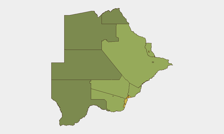
Situation Summary
Botswana remains a low-threat environment overall (composite threat score 4; no tracked active conflict or civil unrest). The most significant recent pattern is a series of wildfires across multiple regions, though these pose indirect rather than direct security risks to corporate operations. Background concern exists around foreign recruitment scams targeting Botswana citizens (reported ~20 July), but no acute security incidents have been verified in the last 24–48 hours. The operating environment for corporate security teams remains stable.
Key Developments
No verified security incidents, civil unrest, conflict events, or significant infrastructure disruptions have been documented in Botswana in the last 24–48 hours. Open-source monitoring shows no time-stamped acute events requiring immediate operational response. Ongoing wildfire activity in multiple regions continues to be tracked but does not currently pose direct threats to major urban or commercial centers.
Highest-Risk Areas
Gaborone (risk 72) remains the highest-risk sub-national area, driven primarily by urban crime, commercial targeting, and density of corporate/diplomatic presence. The South-East District (68) and Lobatse (65) follow; these rankings likely reflect mining-sector activity, border-region dynamics, and localized crime. Francistown and Jwaneng (62 and 61 respectively) are elevated due to resource-extraction operations and associated transient populations. Risk scores decline markedly in more remote and sparsely populated districts (North-West at 38); corporate teams should prioritize duty-of-care protocols in the top four ranked locations and maintain standard situational awareness in mining and border zones.
How GeoBit Would Assist
Corporate security teams monitoring Botswana would deploy AOI (Area-of-Interest) Monitoring & Early Warning on high-risk districts—particularly Gaborone, South-East District, and mining centers—to receive alerts on any emergent unrest, infrastructure disruption, or crime spikes. OSINT (X/Twitter, Telegram, and multi-language local feeds) combined with sentiment and temporal analysis would enable real-time detection of civil unrest, labor disputes, or border incidents before they escalate. GIS & Spatial Analysis would support safe-passage routing and alternative journey planning for personnel traveling between Gaborone and regional operations, especially in elevated-risk zones.
7-Day Outlook
No significant change in the baseline security picture is forecast for the next seven days. Wildfire activity may persist in affected regions but is unlikely to escalate into a systemic threat to corporate operations or personnel movement. Recommended posture: maintain standard protocols in urban centers and mining zones; monitor local labor and community conditions in resource-extraction areas for early signals of tension.
NOTE: This brief reflects available open-source intelligence as of 27 July 2026. Real-time updates on verified incidents will be issued immediately upon corroboration. Duty-of-care teams should supplement this assessment with local embassy advisories and on-ground security partners.
Highest-Risk Areas — Ranked
| # | State / Region | Risk |
|---|---|---|
| 1 | Gaborone | 72 |
| 2 | South-East District | 68 |
| 3 | Lobatse | 65 |
| 4 | Francistown | 62 |
| 5 | Jwaneng | 61 |
| 6 | Selebi Phikwe | 58 |
| 7 | Southern District | 55 |
| 8 | Kgatleng District | 50 |
| 9 | Kweneng District | 48 |
| 10 | North-East District | 45 |
| 11 | Central District | 42 |
| 12 | North-West District | 38 |
Sources
Previous Daily Briefs
A new Botswana brief is written every day — each with its own risk map and downloadable CSV. Here's the last week; use the calendar to go further back.
📅 Browse every day by calendar →
Highlighted days have a brief. Tap a day for that day's map & analysis, or “csv” for that day's dataset ($5).
Atlas — our AI intelligence desk — emails them this snapshot personally. Nothing else, no list.