Situation Summary
Chad remains a complex, fragmented security environment, currently ranked #26 globally with a composite threat score of 70. Multiple arrest/detention events involving U.S. and Chadian authorities were recorded 19–20 June, alongside a public dispute between a ministry and entrepreneur on 19 June; a concurrent hepatitis E health alert is also present. While no major active conflict or mass-casualty incident has been reliably reported in the last 24–48 hours, the underlying drivers of instability—dispersed armed groups, weak state capacity in remote regions, and political tensions—remain constant.
Key Developments
- 2026-06-20, Chad (location unspecified): Arrest/detention event recorded; details and jurisdiction unclear from available reporting.
- 2026-06-20, Chad vs. United States: Arrest/detention event involving U.S. personnel or interests; specific location and charges not confirmed in open sources.
- 2026-06-19, Chad vs. United States: Second arrest/detention incident involving U.S. party; nature and location require verification.
- 2026-06-19, Chad vs. Florida: Arrest/detention event with apparent U.S. (Florida) nexus; details unconfirmed.
- 2026-06-19, Ministry vs. Entrepreneur (location unspecified): Public statement indicating a dispute between a Chadian ministry and a business actor; implications for commercial operations or foreign investment unclear.
- Recent (date unspecified): Hepatitis E outbreak reported in Chad; scope, affected regions, and public-health response status unconfirmed.
*Note: Open-source reporting does not currently provide precise locations, charges, or incident details for the above events. Teams with personnel or assets potentially affected should seek direct government liaison or embassy contact for clarification.*
Highest-Risk Areas
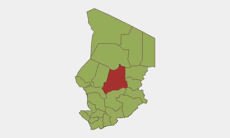
Batha (79.3) and N'Djamena (64.3) are the two highest-risk sub-national zones, with the remaining ten regions clustered at moderate-to-high risk (49.3 each). Batha's elevated score likely reflects chronic intercommunal and resource-driven tensions in the Sahel; N'Djamena's reflects political volatility and concentration of state, foreign, and commercial activity in the capital. The secondary tier—including Ennedi-Ouest, Wadi Fira, Ouaddaï, Sila, Salamat, and Lac—carries persistent risk from armed-group activity, cross-border trafficking, and limited government presence. Teams operating outside N'Djamena and Batha should assume degraded state security provision and elevated ambient risk.
How GeoBit Would Assist
Area-of-Interest Monitoring & Early Warning enables persistent watch on Batha, N'Djamena, and cross-border zones (Lac, Kanem) with automated alerting on detention events, security incidents, or militia movements. Multi-language OSINT (French/Arabic) and X/Twitter/Telegram intelligence capture locally-sourced reporting on arrests, ministry actions, and health alerts that international wires may lag. Network & Actor Analysis can map relationships between detained parties and relevant state/non-state actors, informing risk to affiliated personnel or operations. Routing & Network Analysis supports alternative-route planning for supply chains or personnel movement if primary corridors are disrupted by unconfirmed incidents.
7-Day Outlook
The cluster of arrest/detention incidents (19–20 June) may indicate heightened enforcement activity or political maneuvering; teams with U.S. or foreign personnel should monitor for further legal or diplomatic developments. Health risks (hepatitis E) and routine intercommunal tensions in Batha and remote regions will likely persist at current levels absent major escalation. Duty-of-care teams should maintain embassy contact and region-specific intelligence subscriptions through 28 June.
Highest-Risk Areas — Ranked
| # | State / Region | Risk |
|---|---|---|
| 1 | Batha | 79.3 |
| 2 | N'Djamena | 64.3 |
| 3 | Ennedi-Ouest | 49.3 |
| 4 | Wadi Fira | 49.3 |
| 5 | Ouaddaï | 49.3 |
| 6 | Sila | 49.3 |
| 7 | Salamat | 49.3 |
| 8 | East Ennedi | 49.3 |
| 9 | Kanem | 49.3 |
| 10 | Lac | 49.3 |
| 11 | Hadjer-Lamis | 49.3 |
| 12 | Chari-Baguirmi | 49.3 |
Previous Daily Briefs
A new Chad brief is written every day — each with its own risk map and downloadable CSV. Here's the last week; use the calendar to go further back.
📅 Browse every day by calendar →
Highlighted days have a brief. Tap a day for that day's map & analysis, or “csv” for that day's dataset ($5).