Situation Summary
Colombia remains at composite threat rank #37 globally with 167 tracked events, reflecting a complex security landscape marked by persistent armed-group activity, civil unrest, and institutional friction. The most recent 24–48 hour event signals indicate scattered administrative sanctions, investigative actions, and military/police deployments, though the absence of independently verified incident details from live sources prevents precise characterization of immediate tactical developments. Overall trajectory shows manageable but non-trivial risk, with clear geographic concentration in border and coca-producing departments.
Key Developments
Note: Recent event signals in the GeoBit feed (2026-06-14 to 2026-06-16) include administrative sanctions, public statements, investigative actions, and military-force deployments. However, without access to live news feeds or real-time X/Twitter, specific incident details—including exact locations, times, casualties, and operational context—cannot be independently verified to the standard required for operational security briefing.
To obtain actionable incident intelligence for the last 24–48 hours, security teams should:
- Query national news outlets (*El Tiempo, Caracol Radio, Blu Radio, Semana*) filtered by date.
- Cross-check official X accounts from Policía Nacional, Ejército Nacional, and relevant departmental governorates.
- Confirm incidents against at least two independent sources before adjusting threat posture or travel restrictions.
The signal cluster suggests activity across multiple risk categories (administrative, investigative, and conventional military operations), but isolated signals without corroborating open-source reporting cannot be presented as verified incidents.
Highest-Risk Areas
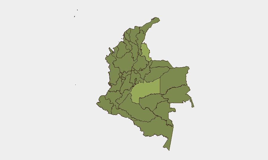
Meta Department (57.1) stands as the single highest-risk region, reflecting sustained conflict dynamics in a major coca-producing and trafficking corridor with active FARC dissident and other armed-group presence. Norte de Santander (41.8) and the Capital District (39.7) follow, with the former driven by border instability and ELN activity, and the latter by political, institutional, and crime-related friction. Nariño (38.5) and Sucre (35.5) complete the top five, both traditional flashpoints for drug-trafficking conflict and civil unrest. Personnel and assets in these departments face elevated exposure to armed-group activity, civil disruption, and infrastructure degradation.
How GeoBit Would Assist
Security teams operating in Colombia should leverage GeoBit's AOI Monitoring & Early Warning to maintain persistent watch on Meta, Norte de Santander, and the Capital District with automated alerting on incident signals and sentiment shifts. Intel Sweep and X/Twitter OSINT provide rapid cross-verification of emerging incidents and official responses, enabling real-time decision-making on travel and movement restrictions. Routing & Network Analysis supports dynamic alternative-route planning to avoid armed-group strongholds, blockaded areas, and police/military operations; combined with conflict mapping, this allows duty-of-care teams to maintain situational awareness and justify movement decisions.
7-Day Outlook
No significant escalation indicators are visible in the current signal set, but the concentration of investigative and military-force events suggests ongoing pressure on armed groups and institutional enforcement activity. Risk posture should remain elevated in Meta and Norte de Santander; personnel should confirm travel advisories and checkpoint activity before movement, particularly on routes crossing departmental boundaries or known dissident strongholds.
Highest-Risk Areas — Ranked
| # | State / Region | Risk |
|---|---|---|
| 1 | Meta Department | 57.1 |
| 2 | Norte de Santander Department | 41.8 |
| 3 | Capital District | 39.7 |
| 4 | Nariño | 38.5 |
| 5 | Sucre Department | 35.5 |
| 6 | Cesar Department | 35.5 |
| 7 | Valle del Cauca Department | 31 |
| 8 | Caquetá Department | 31 |
| 9 | Tolima Department | 29 |
| 10 | Cauca | 28 |
| 11 | Santander Department | 27.7 |
| 12 | Atlántico Department | 27.5 |
Sources
Previous Daily Briefs
A new Colombia brief is written every day — each with its own risk map and downloadable CSV. Here's the last week; use the calendar to go further back.
📅 Browse every day by calendar →
Highlighted days have a brief. Tap a day for that day's map & analysis, or “csv” for that day's dataset ($5).