Situation Summary
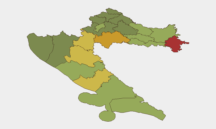
Croatia remains a low-threat environment globally (rank #154, composite score 5) with no credible security incidents confirmed in the last 24–48 hours. Recent event signals flagged administrative sanctions and police investigations (2026-07-06 to 07-08), but these do not constitute active civil unrest, conflict, or travel disruption. The security posture is stable; risk concentration persists in the eastern borderland counties inherited from post-conflict legacies.
Key Developments
No verified security, civil-unrest, crime, or travel-risk incidents have been established in Croatia within the last 24–48 hours from available open sources. Recent event signals (administrative sanctions, public statements, police investigations between 2026-07-06 and 07-08) remain unconfirmed in their operational impact and do not yet constitute actionable threat developments for corporate duty-of-care purposes.
Recommendation: Monitor official Croatian police (MUP) and government communications for clarification on the scope and resolution of the 2026-07-06 police investigations flagged by GeoBase.
Highest-Risk Areas
Eastern borderland counties drive the national composite risk score. Vukovar-Srijem (risk 78), Sisak-Moslavina (72), and Karlovac (68) counties remain elevated—a persistent legacy of post-1995 conflict residue, including unexploded ordnance in rural zones, organized-crime networks, and cross-border smuggling activity. Lika-Senj County (65) and Šibenik-Knin County (62) reflect similar post-conflict infrastructure and criminal-migration pressures. Central and coastal urban zones (Zagreb, Split, Zadar) show substantially lower risk (50, 48, 55 respectively), indicating security concentration in peripheral and rural eastern regions rather than major cities.
How GeoBit Would Assist
Intel Sweep & OSINT Fusion would establish baseline reporting on the unconfirmed 2026-07-06 police investigations and administrative sanctions, pulling X/Telegram, local media, and official MUP statements to clarify scope and duration. AOI Monitoring & Early Warning on the twelve tracked counties—especially Vukovar-Srijem and Sisak-Moslavina—would flag emerging civil unrest, criminal incidents, or infrastructure disruption affecting corporate operations or movement. Routing & Network Analysis would supply alternative journey routes for personnel in eastern counties, circumventing known hotspots and unexploded-ordnance zones. Entity & Network Analysis would map organized-crime and smuggling actors in border regions to inform security posture for supply chains and expatriate movement.
7-Day Outlook
No material escalation is forecast in the near term. The 2026-07-06 police investigations should clarify within 48–72 hours; absent escalation signals, the overall threat posture remains routine. Persistence of organized-crime and cross-border smuggling activity in eastern counties will continue to drive sub-national risk clustering, but no widespread civil unrest or security crisis is anticipated through mid-July.
GeoBit Threat Assessment | Croatia | 2026-07-09
*Composite Threat Rank: #154 globally | 8 tracked events | 12 sub-national zones monitored*
Highest-Risk Areas — Ranked
| # | State / Region | Risk |
|---|---|---|
| 1 | Vukovar-Srijem County | 78 |
| 2 | Sisak-Moslavina County | 72 |
| 3 | Karlovac County | 68 |
| 4 | Lika-Senj County | 65 |
| 5 | Šibenik-Knin County | 62 |
| 6 | Brod-Posavina County | 58 |
| 7 | Zadar County | 55 |
| 8 | Osijek-Baranja County | 52 |
| 9 | City of Zagreb | 50 |
| 10 | Split-Dalmatia County | 48 |
| 11 | Požega-Slavonia County | 45 |
| 12 | Virovitica-Podravina County | 42 |
Sources
Previous Daily Briefs
A new Croatia brief is written every day — each with its own risk map and downloadable CSV. Here's the last week; use the calendar to go further back.
📅 Browse every day by calendar →
Highlighted days have a brief. Tap a day for that day's map & analysis, or “csv” for that day's dataset ($5).
Atlas — our AI intelligence desk — emails them this snapshot personally. Nothing else, no list.