Situation Summary
Cyprus remains at composite threat level 5 (rank #154 globally), reflecting moderate risk with volatile regional dynamics. The island itself has experienced no credible security incidents within territorial waters or on land in the last 24–48 hours; however, Cyprus-flagged maritime assets operating in high-risk shipping lanes—particularly the Strait of Hormuz—face elevated exposure to state and non-state actors. Escalating Iran–U.S. tensions, coupled with unresolved Turkey–Cyprus disputes in the north, sustain structural vulnerabilities that warrant active duty-of-care monitoring for organizations with employees or assets in Cyprus or operating Cyprus-flagged vessels.
Key Developments
- Strait of Hormuz, 10–11 July 2026 – Cyprus-flagged container vessel attacked by Iranian forces. A Cyprus-registered ship sustained significant engine-room damage and reported one civilian crew member missing following a strike attributed to Iranian naval units. U.S. Central Command publicly confirmed the incident; follow-on statements from Washington describe the attack as part of broader Iranian targeting of commercial shipping in the strait.
- 7–12 July 2026 – U.S. retaliatory strikes on Iranian targets. U.S. precision operations targeting more than 80–180 Iranian sites were conducted in response to attacks on commercial vessels, including the Cyprus-flagged ship. These strikes represent the most significant kinetic escalation in the Iran–U.S. maritime conflict in 18 months and signal heightened risk for all flag-state shipping transiting the Persian Gulf and Strait of Hormuz.
- 12 July 2026 – Cyprus government public statements and diplomatic disapproval. Cyprus issued official statements condemning the attack on its flagged vessel and expressed formal disapproval of Iranian military action. No new Cyprus domestic security incidents or policy changes have been reported.
- 10–12 July 2026 – Turkey–Cyprus tensions remain elevated. Turkish rejection statements on 10 July and ongoing Turkish–Cyprus disputes underscore the persistence of northern maritime and territorial disagreements; no new kinetic incidents have been confirmed on land or in the buffer zone.
Highest-Risk Areas
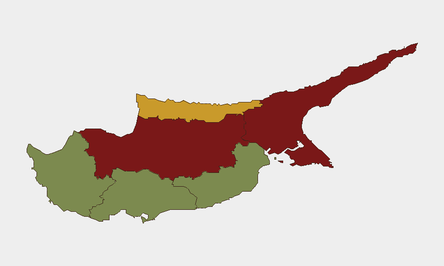
Nicosia (92) and Famagusta (88) dominate risk rankings, driven by proximity to the UN-patrolled buffer zone, Turkish military presence in the north, and unresolved political status. Kyrenia (72) presents secondary elevated risk due to maritime border sensitivity and Turkish-controlled waters. Larnaca, Limassol, and Paphos (28, 22, 18 respectively) carry substantially lower risk; Limassol and Paphos are primary hubs for expatriate business and tourism and remain operationally stable. Risk concentration in the north reflects geopolitical division rather than active armed conflict, but tension-driven incidents (demonstrations, road closures, border friction) occur periodically and warrant situational awareness for teams transiting the buffer zone or working in Nicosia.
How GeoBit Would Assist
Security teams should deploy AOI (Area-of-Interest) Monitoring & Early Warning on Nicosia, Famagusta, and Kyrenia to capture emerging civil-unrest, border-friction, and demonstration signals in real time. Maritime tracking and conflict-zone OSINT (Intel Sweep, entity extraction, and X/Telegram monitoring) provide continuous visibility into Cyprus-flagged vessel movements and Iran–U.S. naval activity affecting shipping corridors. Routing & Network Analysis capabilities enable alternative-route planning for personnel and cargo transiting the eastern Mediterranean and Persian Gulf, reducing exposure to high-threat chokepoints.
7-Day Outlook
Iran–U.S. maritime tensions are expected to remain elevated; further attacks on commercial shipping or retaliatory U.S. operations would likely follow established patterns in the Strait of Hormuz and Gulf of Aden rather than escalate toward Cyprus itself. Domestic Cyprus security is forecast to remain stable; Turkey–Cyprus border rhetoric may intensify in response to U.S.–Iran developments, but no new kinetic incidents are anticipated within the next 7 days absent a major regional shock.
Highest-Risk Areas — Ranked
| # | State / Region | Risk |
|---|---|---|
| 1 | Nicosia | 92 |
| 2 | Famagusta | 88 |
| 3 | Kyrenia | 72 |
| 4 | Larnaca | 28 |
| 5 | Limassol | 22 |
| 6 | Paphos | 18 |
Sources
Previous Daily Briefs
A new Cyprus brief is written every day — each with its own risk map and downloadable CSV. Here's the last week; use the calendar to go further back.
📅 Browse every day by calendar →
Highlighted days have a brief. Tap a day for that day's map & analysis, or “csv” for that day's dataset ($5).
Atlas — our AI intelligence desk — emails them this snapshot personally. Nothing else, no list.