Situation Summary
Dominica presents a low acute security environment as of 6 August 2026, with no verified security incidents, civil unrest, conflict activity, or infrastructure disruptions reported in the last 24–48 hours. The national risk composite score remains at 2, placing Dominica well outside the top threat tier globally. Baseline risks—petty crime of opportunity, poor road infrastructure, and occasional localized incidents—persist but show no signs of escalation or concentration into a coordinated or acute threat.
Key Developments
No verified security, conflict, civil unrest, crime, political instability, infrastructure, or travel-risk incidents have been confirmed in Dominica in the last 24–48 hours.
*Note on unverified signals:* A circulating social-media post claims a nationwide 6 pm–6 am curfew and "State of Emergency," but this claim lacks official government announcement, media corroboration, or confirmed dating. It has been flagged as an intelligence lead requiring follow-up, not as a confirmed current event. GeoBit monitoring will continue to validate or refute this signal.
The most recent structured security assessment (29 July 2026) recorded no discrete incidents and classified Dominica as low-risk. U.S. State Department travel guidance (current) maintains Dominica at Level 1 (exercise normal precautions), citing only endemic petty crime and baseline infrastructure challenges.
Highest-Risk Areas
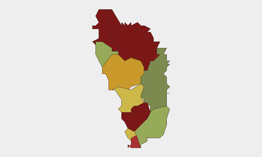
Saint Andrew Parish (risk 92), Saint John Parish (risk 88), and Saint George Parish (risk 81) rank highest in the sub-national composite assessment, together accounting for the bulk of tracked risk exposure. Saint Andrew's significantly elevated score suggests concentration of petty crime, informal-economy activity, or socioeconomic stress; similar drivers likely apply to Saint John and Saint George. Together, these three parishes warrant proportionately higher duty-of-care monitoring if assets or personnel are present. Remaining parishes (Saint Mark, Joseph, Paul, Luke, Peter, Patrick, David) display declining risk, with Saint David the lowest at 35—a pattern consistent with crime and opportunity concentration in larger urban or commercial nodes.
How GeoBit Would Assist
Security teams operating in Dominica should deploy AOI Monitoring & Early Warning on Saint Andrew, Saint John, and Saint George parishes to detect emerging crime clusters, unauthorized assembly, or infrastructure disruption in near-real-time. Intel Sweep (X/Twitter, Telegram, YouTube, multi-language OSINT) paired with sentiment & temporal analysis will validate or refute the unconfirmed curfew/State of Emergency rumor and detect any cascade of related signals. For duty-of-care planning, Routing & Network Analysis can identify alternative transport corridors in higher-risk parishes, and entity extraction & network analysis will map local actors and friction points relevant to asset or personnel safety.
7-Day Outlook
No indicators suggest acute escalation over the next 7 days. The unverified curfew claim will remain a low-confidence lead unless corroborated by official announcement or regional media; if confirmed, it would materially elevate risk and warrant immediate scenario planning. Baseline crime and road-safety risks will continue; corporate teams should maintain standard precautions and keep GeoBit monitoring active to catch any transition from baseline to elevated status.
Highest-Risk Areas — Ranked
| # | State / Region | Risk |
|---|---|---|
| 1 | Saint Andrew Parish | 92 |
| 2 | Saint John Parish | 88 |
| 3 | Saint George Parish | 81 |
| 4 | Saint Mark Parish | 78 |
| 5 | Saint Joseph Parish | 72 |
| 6 | Saint Paul Parish | 68 |
| 7 | Saint Luke Parish | 62 |
| 8 | Saint Peter Parish | 55 |
| 9 | Saint Patrick Parish | 48 |
| 10 | Saint David Parish | 35 |
Sources
Previous Daily Briefs
A new Dominica brief is written every day — each with its own risk map and downloadable CSV. Here's the last week; use the calendar to go further back.
📅 Browse every day by calendar →
Highlighted days have a brief. Tap a day for that day's map & analysis, or “csv” for that day's dataset ($5).
Atlas — our AI intelligence desk — emails them this snapshot personally. Nothing else, no list.