Situation Summary
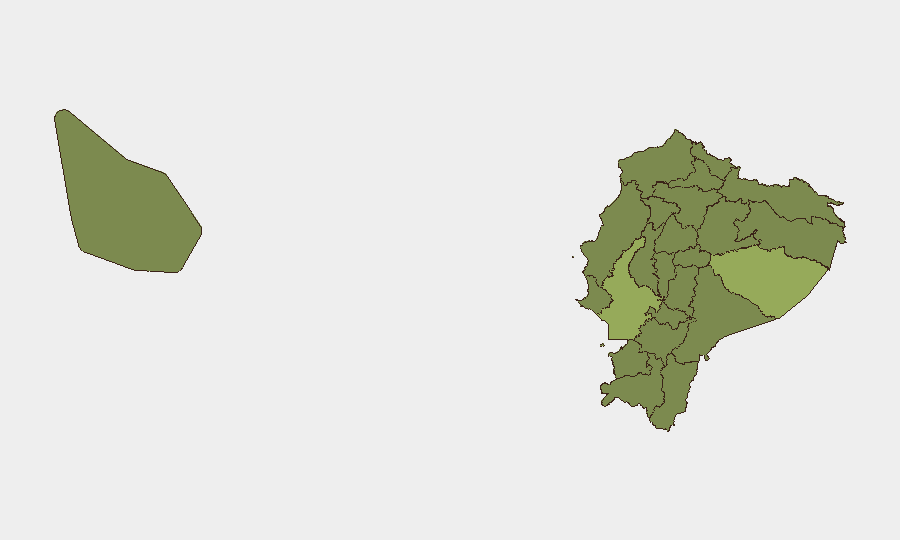
Ecuador remains at moderate composite threat level (#43 globally, score 38) with 63 tracked events, driven primarily by organized crime activity, prison violence, and localized civil unrest. Guayas Province (primarily the port city of Guayaquil and surrounding areas) remains the dominant risk driver, followed by Pastaza in the Amazonian interior. The security picture reflects ongoing competition between criminal organizations for control of trafficking routes and detention facilities, with secondary spillover affecting coastal and border provinces.
Key Developments
Incident-level reporting for the past 24–48 hours cannot be reliably confirmed from available sources. GeoBit's event signals show multiple activity markers flagged on 2026-06-15 and 2026-06-16 (small arms combat, military deployments, prosecution actions, and civil statements), but without independent corroboration from ECU911, Policía Nacional, or major local news outlets (El Universo, El Comercio, Primicias), precise location, timing, and nature of these incidents remain unverified.
Security teams requiring same-day incident confirmation should consult:
- ECU911 incident portal and Policía Nacional official channels for real-time reports
- US, UK, and EU travel advisory updates (often issued same-day for significant incidents)
- Major Ecuador news outlets in Spanish for localized incident confirmation
Highest-Risk Areas
Guayas Province (risk score 56.6) dominates the threat landscape, driven by its role as Ecuador's primary port and logistics hub—critical infrastructure regularly targeted by organized crime for drug trafficking, arms smuggling, and extortion. Pastaza Province (50.6), an Amazonian region with limited state presence and porous borders, faces persistent threats from illegal mining, drug production, and armed groups operating across the Peru–Ecuador frontier. Manabí Province (33.5), Ecuador's second-largest coastal region, experiences secondary spillover from maritime trafficking and criminal organization territorial disputes. Together, these three provinces account for the majority of violent incidents and represent the highest duty-of-care risk for corporate operations in Ecuador.
How GeoBit Would Assist
Area-of-Interest (AOI) Monitoring & Early Warning would enable real-time alerting on incidents, curfews, and roadblocks within defined corporate footprints (e.g., port facilities in Guayaquil, supply chains in Manabí, border operations in Pastaza). Conflict & Military mapping, plus Network & Actor Analysis, would identify armed group presence, territorial control, and criminal organization leadership to inform travel routing and facility security. Routing & Network Analysis would support alternative journey planning to avoid active conflict zones, roadblocks, and known extortion corridors—critical for personnel and asset movement in high-risk provinces.
7-Day Outlook
Expect continued operational activity by organized crime in Guayas and Pastaza, with potential for localized clashes between rival factions or law enforcement responses. Prison-related incidents and civil statements flagged in the event data suggest possible policy or institutional actions that may affect movement or local stability in mid-June. Security posture should remain elevated in coastal and border provinces; monitor official channels for any state-of-emergency declarations or curfew announcements that could disrupt supply chains or personnel operations.
Highest-Risk Areas — Ranked
| # | State / Region | Risk |
|---|---|---|
| 1 | Guayas Province | 56.6 |
| 2 | Pastaza Province | 50.6 |
| 3 | Manabí Province | 33.5 |
| 4 | Santa Elena Province | 26.9 |
| 5 | Sucumbíos Province | 26.6 |
| 6 | Orellana Province | 26.6 |
| 7 | Galápagos | 26.6 |
| 8 | Esmeraldas Province | 26.6 |
| 9 | Carchi Province | 26.6 |
| 10 | Imbabura Province | 26.6 |
| 11 | Santo Domingo de los Tsáchilas Province | 26.6 |
| 12 | Pichincha Province | 26.6 |
Sources
Previous Daily Briefs
A new Ecuador brief is written every day — each with its own risk map and downloadable CSV. Here's the last week; use the calendar to go further back.
📅 Browse every day by calendar →
Highlighted days have a brief. Tap a day for that day's map & analysis, or “csv” for that day's dataset ($5).