Situation Summary
Equatorial Guinea remains a composite Tier-4 global security risk (rank #166), with no discrete security incidents reported in the last 24–48 hours. Structural vulnerabilities—elevated street crime in urban centers (Malabo, Bata), armed piracy in territorial waters, and ad-hoc border closures on the mainland—persist as ongoing hazards rather than acute developments. The security environment is characterized by chronic rather than acute deterioration, though corporate and diplomatic presence should maintain elevated vigilance, particularly in Bioko Norte and Litoral Province.
Key Developments
- No time-stamped security incidents recorded in Equatorial Guinea in the last 24–48 hours. Available diplomatic advisories (Spanish Foreign Ministry, regional OSINT feeds) describe *ongoing* elevated-crime and piracy risk but do not cite specific dated events in the requested window.
- Ebola quarantine framework remains in force (dated 18 June 2026). All arrivals from Uganda and DRC-endemic regions are subject to mandatory 21-day quarantine; this is background control policy, not a new incident, but affects duty-of-care planning for personnel movement.
- Armed piracy in Bioko Island waters characterized as recurring threat. Spanish diplomatic sources confirm multiple vessel types (including passenger craft) have been targeted; recreational navigation off Bioko is prohibited. No individual attack with a current-window date is recorded, but the pattern indicates sustained maritime risk.
- Border control and checkpoint variation reported as ongoing. Land borders on the mainland (Litoral, Wele-Nzas, Kié-Ntem provinces) experience ad-hoc closures and heightened inspection; this is contextual friction, not a discrete closure event in the last 48 hours, but affects overland logistics planning.
Highest-Risk Areas
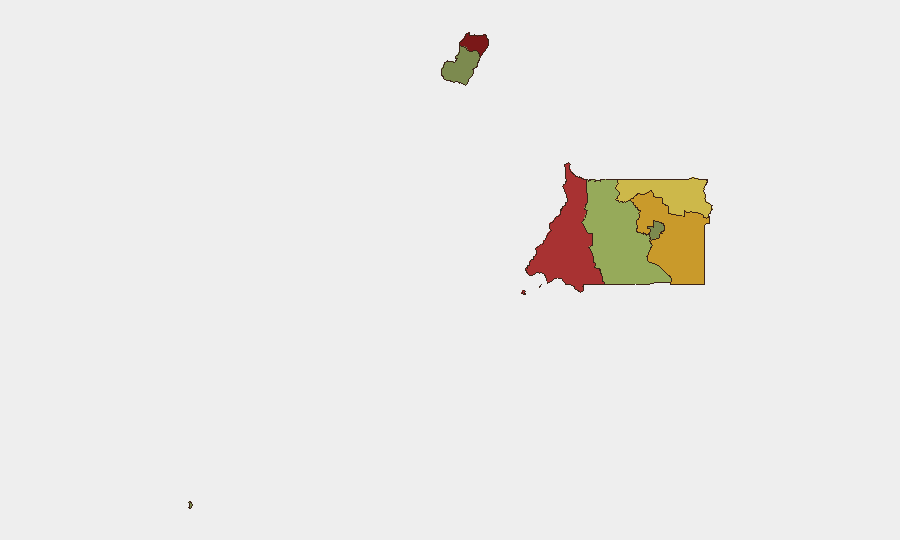
Bioko Norte (risk 85) and Litoral Province (risk 78) drive the national risk profile, both anchored in street crime (robbery, assault, nighttime targeting of foreigners) concentrated in Malabo and Bata. Wele-Nzas (72) and Kié-Ntem (68) provinces, both on the mainland border with Cameroon, reflect cross-border trafficking, contraband movement, and weaker state control. Centro Sur (45) shows moderate structural fragility. The interior and southern islands (Djibloho 15, Annobón 8) present minimal reporting and lower comparative risk but remain data-sparse environments.
How GeoBit Would Assist
Security teams managing Equatorial Guinea operations should deploy AOI Monitoring & Early Warning (persistent watch on Malabo, Bata, and Bioko coastal zones with automated incident alerting), multi-language OSINT fusion (Spanish-language diplomatic, NGO, and local news synthesis), and alternative route/network analysis (for overland and maritime transit around piracy and checkpoint zones). Satellite & imagery analysis and maritime tracking provide forward situational awareness for asset movement and port risk, while entity extraction and sentiment analysis (applied to Spanish-language social media and regional news) offer early signals of deterioration in specific neighborhoods or sectors.
7-Day Outlook
No material escalation in discrete incidents is forecast for the next 7 days; the security environment is expected to remain in its current steady state of chronic street crime and maritime piracy with limited acute shocks. Personnel rotation, logistics movement, and maritime operations should continue to assume persistent baseline risks in Bioko Norte and Litoral Province rather than preparing for emergency evacuation. Routine duty-of-care protocols (curfew observance, avoided nighttime transit in Malabo/Bata, maritime escort for vessel movement) remain the appropriate operational posture.
Highest-Risk Areas — Ranked
| # | State / Region | Risk |
|---|---|---|
| 1 | Bioko Norte | 85 |
| 2 | Litoral Province | 78 |
| 3 | Wele-Nzas Province | 72 |
| 4 | Kié-Ntem Province | 68 |
| 5 | Centro Sur Province | 45 |
| 6 | Bioko Sur | 38 |
| 7 | Djibloho | 15 |
| 8 | Annobón Province | 8 |
Sources
Previous Daily Briefs
A new Equatorial Guinea brief is written every day — each with its own risk map and downloadable CSV. Here's the last week; use the calendar to go further back.
📅 Browse every day by calendar →
Highlighted days have a brief. Tap a day for that day's map & analysis, or “csv” for that day's dataset ($5).
Atlas — our AI intelligence desk — emails them this snapshot personally. Nothing else, no list.