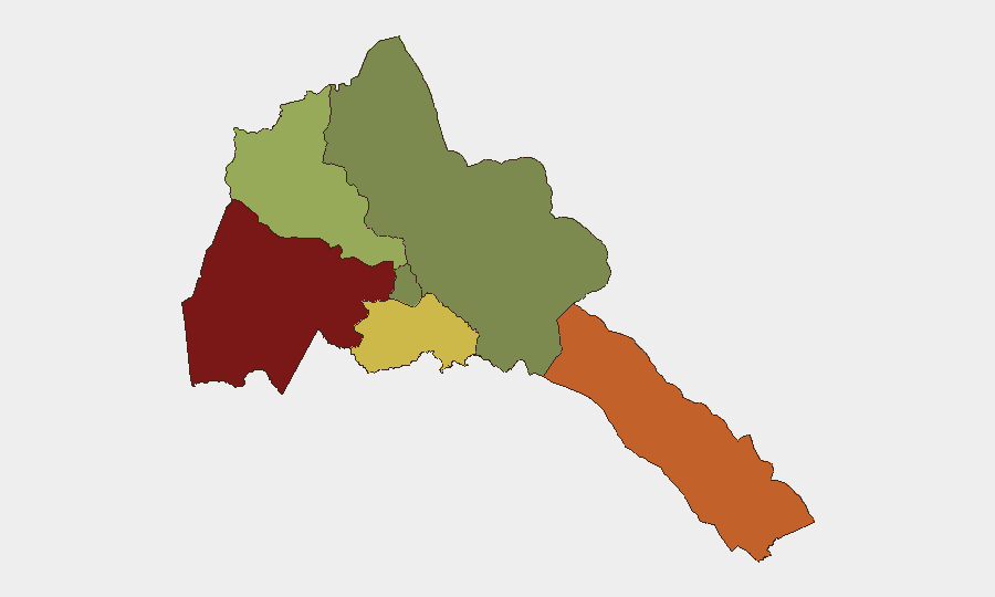
Situation Summary
Eritrea remains a high-opacity, structurally volatile environment with composite threat score 2.6 globally, reflecting persistent internal repression, limited independent reporting, and exposure to regional geopolitical instability in the Horn of Africa and Red Sea corridor. No specific security incidents with verified time and location have been reported in open sources over the last 24–48 hours; current risk instead derives from ongoing regional military positioning (particularly Egyptian naval agreements at Eritrean ports), unresolved border and sovereignty tensions with neighbours, and endemic government restrictions on movement, expression, and scrutiny. Travel risk advisories remain elevated due to potential for interstate conflict escalation, not from discrete new events. The country's security posture is best understood as a slow-burn structural risk rather than an active, acute crisis at this moment.
Key Developments
- Journalist statement vs. Eritrea (2026-07-16) — A public statement by a journalist regarding Eritrea was logged as a tracked event on 16 July; open-source detail remains limited. No incident location or specific claim is yet corroborated in independent media feeds.
- Regional naval positioning — Red Sea / Gulf of Aden (mid-July 2026) — Reporting indicates Egypt is securing port access and supply agreements at Eritrean facilities as part of broader strategic pressure in the Nile/GERD dispute with Ethiopia. This reflects Eritrea's continued role in Red Sea militarization, though no new combat or major clash is documented.
- Ongoing diplomatic rebuttal — Eritrea (July 2026) — Regional media notes Eritrea is actively contesting accusations of hostile regional alignments and engaging in sovereignty/access disputes. This is diplomatic/narrative activity rather than a ground-level security incident.
- Persistent internal restrictions (structural, ongoing) — Human rights sources document continued forced conscription, labor practices, severe limits on expression and movement, and absence of independent oversight. These form the baseline risk environment for any personnel or operations in-country.
Note: The absence of reliable, timestamped incident reporting for 15–16 July reflects Eritrea's limited independent media access, not necessarily absence of security events. Local incidents, detentions, or clashes may occur but remain unreported in open channels.
Highest-Risk Areas
Gash-Barka (risk 92) and Southern Red Sea Region (risk 75) drive the country's threat profile, likely due to border proximity, port militarization, and cross-border militia or trafficking activity. Debub Region (risk 68) presents secondary concern, while Maekel Region (Asmara, risk 18) is relatively lower but remains subject to state surveillance and restricted movement. The disparity underscores that risk in Eritrea is geographically uneven; peripheral and border zones face higher exposure to regional conflict spillover and military activity, while the capital is subject primarily to political/surveillance risk rather than active conflict.
How GeoBit Would Assist
Security teams with Eritrea exposure should deploy AOI (Area-of-Interest) Monitoring & Early Warning on Gash-Barka and Southern Red Sea Region to detect military movements, port activity, or cross-border incidents before they escalate. Intel Sweep and regional OSINT fusion (monitoring Ethiopia, Sudan, and Red Sea actors as proxy indicators) compensate for Eritrea's media opacity. Closed-loop Travel Risk Assessment and alternative route planning help duty-of-care teams maintain situational awareness and contingency options for personnel movement in a high-restriction environment.
7-Day Outlook
No acute escalation is signaled for the immediate week; however, regional geopolitical momentum (Egyptian-Eritrean naval coordination, GERD tensions, Red Sea militarization) creates latent risk of rapid change. Travel restrictions and internal repression will remain steady-state. Monitor regional actor statements and port activity as leading indicators of any shift in Eritrea's security posture.
Highest-Risk Areas — Ranked
| # | State / Region | Risk |
|---|---|---|
| 1 | Gash-Barka | 92 |
| 2 | Southern Red Sea Region | 75 |
| 3 | Debub Region | 68 |
| 4 | Anseba | 55 |
| 5 | Maekel Region | 18 |
| 6 | Northen Red Sea Region | 0 |
Sources
Previous Daily Briefs
A new Eritrea brief is written every day — each with its own risk map and downloadable CSV. Here's the last week; use the calendar to go further back.
📅 Browse every day by calendar →
Highlighted days have a brief. Tap a day for that day's map & analysis, or “csv” for that day's dataset ($5).
Atlas — our AI intelligence desk — emails them this snapshot personally. Nothing else, no list.