Situation Summary
Guyana remains a medium-to-high risk environment with structural crime and organized activity concentrated in urban centers and border regions, rather than acute national instability or political upheaval as of 1 August 2026. The Guyana Defence Force maintains heightened alert posture along the Venezuela, Suriname, and Brazil borders following late-July developments in the region, though the Prime Minister has reported no hostile incidents to date. No discrete security events have been documented in the past 24–48 hours; the current threat picture reflects persistent baseline conditions in Georgetown and the mining/maritime sectors rather than a deteriorating or rapidly evolving crisis.
Key Developments
Border security posture – Venezuela frontier (late July 2026, ongoing)
The GDF has reinforced monitoring and alert status along Guyana's borders with Venezuela, Suriname, and Brazil in response to regional developments; no hostile activity has been reported, but cross-border traffic remains under close observation.
Chronic crime environment – Georgetown and urban centers (current advisory status)
U.S. and Canadian travel advisories remain in effect, citing armed robbery, aggravated theft, and homicide as persistent concerns in Georgetown and major towns; no specific incident spike in the past 48 hours, but operational security protocols for movement, banking, and night travel remain standard for corporate personnel.
Mining and maritime sector activity (baseline assessment)
Illegal mining, maritime trafficking, and labor-related incidents have historically characterized the interior and coastal zones; no new event reported in the last 24–48 hours, but these sectors remain inherently higher-risk for supply-chain disruption and personnel safety.
*Note: Open-source reporting for the 24–48 hour window yields no additional discrete incidents. Most recent crime reports in accessible sources are dated late June 2026 and are therefore excluded per analytical protocol.*
Highest-Risk Areas
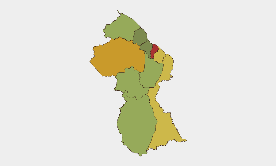
Demerara-Mahaica (risk 78) and Cuyuni-Mazaruni (risk 72) account for the largest share of composite risk, driven by Georgetown's concentration of armed crime, robbery targeting businesses and expatriates, and organized activity in the mining sector. Mahaica-Berbice (65) and East Berbice-Corentyne (62) extend this pattern eastward into the sugar belt and coastal zones, where labor disputes, trafficking, and smuggling remain endemic. Interior and border regions (Upper Demerara-Berbice, Potaro-Siparuni, Barima-Waini) carry secondary but significant risk from illegal mining operations, limited law-enforcement reach, and unregulated border crossing. The risk gradient reflects geography: populated urban and agricultural zones near the coast present higher absolute incident rates; remote interior and island zones present lower frequency but higher impact when incidents occur (medical evacuation delays, limited security response).
How GeoBit Would Assist
Intel Sweep and multi-language OSINT would maintain continuous awareness of crime trends, GDF posture, and Venezuelan/Surinamese border activity—critical given the lag in open-source reporting. AOI Monitoring & Early Warning applied to Georgetown, mining concessions, and border checkpoints would enable real-time alerting if crime clusters, GDF deployments, or cross-border incidents emerge. Routing & Network Analysis supports safe-passage planning for personnel and supply movements, while Satellite & Imagery Analysis can track activity patterns at high-risk sites (ports, mining areas, border posts) to inform duty-of-care decisions.
7-Day Outlook
Border alert posture is likely to remain elevated through early August unless regional Venezuela developments stabilize or de-escalate; no imminent trigger for domestic unrest is evident. Crime in urban centers will persist at current baseline; no catalyst for a significant spike is apparent. Corporate security teams should maintain standard protective protocols and monitor GDF/government statements for any shift in threat posture.
Highest-Risk Areas — Ranked
| # | State / Region | Risk |
|---|---|---|
| 1 | Demerara-Mahaica | 78 |
| 2 | Cuyuni-Mazaruni | 72 |
| 3 | Mahaica-Berbice | 65 |
| 4 | East Berbice-Corentyne | 62 |
| 5 | Upper Demerara-Berbice | 58 |
| 6 | Potaro-Siparuni | 48 |
| 7 | Barima-Waini | 45 |
| 8 | Upper Takutu-Upper Essequibo | 42 |
| 9 | Pomeroon-Supenaam | 38 |
| 10 | Essequibo Islands | 35 |
Sources
Previous Daily Briefs
A new Guyana brief is written every day — each with its own risk map and downloadable CSV. Here's the last week; use the calendar to go further back.
📅 Browse every day by calendar →
Highlighted days have a brief. Tap a day for that day's map & analysis, or “csv” for that day's dataset ($5).
Atlas — our AI intelligence desk — emails them this snapshot personally. Nothing else, no list.