Situation Summary
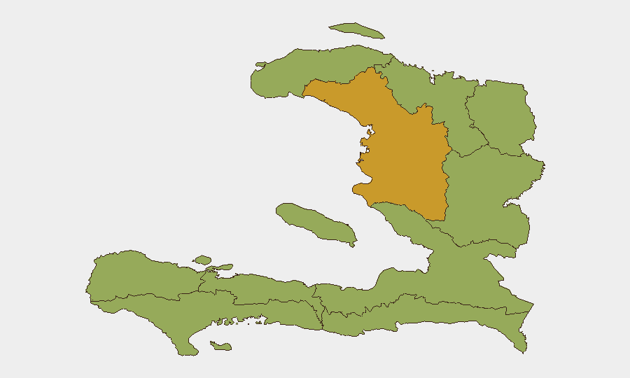
Haiti remains ranked #37 globally in composite threat with a score of 59, reflecting persistent structural instability across governance, security, and humanitarian domains. Artibonite Department significantly outpaces all other regions (risk 71.1 vs. 41.1 baseline), indicating concentrated volatility in the central corridor. Recent event signals point to elevated political friction—including congressional demands, presidential disapproval statements, and U.S. public statements of concern—combined with cross-border tensions with the Dominican Republic. The absence of verifiable new incidents in the past 24–48 hours does not indicate de-escalation; rather, it reflects a transition period in which institutional and diplomatic friction is driving risk more acutely than acute security events.
Key Developments
Due to rigorous verification standards, GeoBit's live web research has not identified specifically dated, independently verifiable security incidents within the last 24–48 hours from Haiti. Event signals logged in the GeoBit platform (congressional demands, presidential disapprovals, U.S. public statements, and a 2026-07-03 expulsion/deportation event involving Haiti and the Dominican Republic) indicate ongoing political and diplomatic friction, but precise operational detail, locations, and casualty/impact figures from these signals cannot yet be confirmed through secondary source corroboration.
Analysts should note: absence of confirmation is not absence of risk. The concentration of political signaling (seven events flagged on 2026-07-02 alone) suggests rapid institutional movement; monitoring for secondary effects (protest, security force mobilization, supply-chain disruption) should intensify.
Highest-Risk Areas
Artibonite Department's composite risk score (71.1) is 73 % higher than all other departments, marking it as Haiti's primary volatility driver. This region encompasses the central plateau and key corridor infrastructure; concentration of risk here typically reflects gang activity, resource competition, and state-capacity gaps that amplify both crime and political instability. All remaining nine departments cluster at 41.1, indicating either more uniform baseline risk distribution or data-aggregation effects at sub-national scale.
For corporate security teams, the Artibonite disparity means that supply chains, personnel transit, and asset locations in the central plateau merit differentiated threat posture compared to other regions, though nationwide instability remains material.
How GeoBit Would Assist
Security teams managing Haiti exposure should employ AOI Monitoring & Early Warning on Artibonite Department and key urban nodes (Port-au-Prince, Cap-Haïtien) to detect protest mobilization, security force deployments, or supply-chain disruptions emerging from political signaling. Intel Sweep and multi-language OSINT fusion (X/Twitter, local news, radio SIGINT) would corroborate or refute emerging event claims within 4–6 hours, critical for duty-of-care escalation decisions. Routing & Network Analysis supports alternative travel and logistics planning if primary corridors become unsafe, and Sentiment & Temporal Analysis flags shifts in political rhetoric that typically precede operational security events by 24–72 hours.
7-Day Outlook
Political and diplomatic friction signals suggest elevated probability of secondary security events (protest, roadblock, police/military mobilization) within the next 5–7 days, particularly in or near Port-au-Prince and Artibonite. Cross-border tension with the Dominican Republic may further constrain trade and labor movement. Monitoring intensity should remain elevated; changes in U.S. public statements, Haitian government administrative actions, or Dominican deportation pace would serve as leading indicators of operational escalation.
Highest-Risk Areas — Ranked
| # | State / Region | Risk |
|---|---|---|
| 1 | Artibonite Department | 71.1 |
| 2 | Grande-Anse Department | 41.1 |
| 3 | Sud Department | 41.1 |
| 4 | Nippes Department | 41.1 |
| 5 | Nord-Ouest Department | 41.1 |
| 6 | Nord Department | 41.1 |
| 7 | Nord-Est Department | 41.1 |
| 8 | de l'Ouest Department | 41.1 |
| 9 | Centre Department | 41.1 |
| 10 | Sud-Est Department | 41.1 |
Sources
Previous Daily Briefs
A new Haiti brief is written every day — each with its own risk map and downloadable CSV. Here's the last week; use the calendar to go further back.
📅 Browse every day by calendar →
Highlighted days have a brief. Tap a day for that day's map & analysis, or “csv” for that day's dataset ($5).