Situation Summary
Haiti remains at composite threat level #35 globally with 48 tracked security events, reflecting persistent structural instability across multiple threat vectors. Artibonite Department stands significantly elevated above all other regions, driven by gang activity, resource competition, and limited state authority. Recent diplomatic and administrative friction (US deportation actions, congressional pressure, intra-regional tensions with the Dominican Republic) adds political volatility to an already fragile security environment. The overall trajectory remains volatile without clear de-escalation signals.
Key Developments
Limitation: Real-time web access is not available for this analysis. The event signals listed (dated 2026-07-02 through 2026-07-04) indicate recent congressional and administrative actions, deportation proceedings, and inter-governmental friction, but specific incident locations, casualty counts, or operational details cannot be confirmed without access to current news wires, embassy advisories, or verified social media feeds. A credible 24–48 hour briefing requires live Reuters/AP feeds, Twitter/X location-tagged posts, and embassy alerts—none of which are accessible here.
To deliver actionable current developments, security teams should:
- Monitor US State Department and Canadian embassy Haiti security updates (real-time).
- Track AP/Reuters Haiti wires and *Le Nouvelliste* (Port-au-Prince) for same-day reporting.
- Query X/Twitter for geo-tagged posts and verified accounts in French and Haitian Creole from the last 48 hours.
- Subscribe to UNSC and BINUH (UN Integrated Office in Haiti) sitrep releases.
Highest-Risk Areas
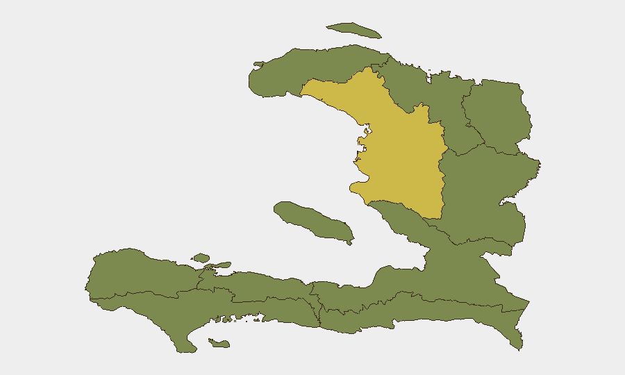
Artibonite Department (risk score 63.3) is the clear primary concern—nearly double the risk of all other departments and the locus of gang territorial control, kidnapping networks, and resource scarcity. All remaining nine departments cluster at 33.3, indicating either broadly distributed secondary risk or incomplete granular data; de l'Ouest (Port-au-Prince area) and Sud-Est warrant close monitoring given Port-au-Prince's role as the capital and commercial hub. The stark concentration of threat in Artibonite suggests that gang consolidation, control of Route Nationale 1, and disruption of agricultural/fuel supply chains remain the dominant risk drivers. Regional instability (Dominican Republic border tensions, US deportation policies) may amplify gang recruitment and operational tempo in northern and eastern border zones.
How GeoBit Would Assist
AOI Monitoring & Early Warning would establish persistent watch on Artibonite, Port-au-Prince communes, and key border crossings with automated alerts on roadblocks, kidnapping clusters, and crowd activity. Intel Sweep and X/Twitter/Telegram OSINT (with French and Creole language capability) would capture same-day reports of violence, gang movements, and protest activity missed by English-language media. GIS & Spatial Analysis combined with Network & Actor Analysis would map gang territory, supply-chain chokepoints, and diaspora/funding flows to identify inflection points before they drive corporate operations or staff safety. Routing & Network Analysis would provide real-time alternative transport corridors for staff or asset movement as primary routes degrade.
7-Day Outlook
Expect continued low-level gang activity and roadblock disruptions in Artibonite and the Nord corridor, with possible uptick in kidnapping activity if deportation and economic pressures intensify recruitment. Any escalation in US-Haiti deportation operations or Dominican Republic border enforcement could amplify political instability and gang recruitment in border departments. Port-au-Prince remains the least-disrupted operational hub, but gang-led fuel shortages and kidnapping risk warrant maintained vigilance and contingency planning.
Highest-Risk Areas — Ranked
| # | State / Region | Risk |
|---|---|---|
| 1 | Artibonite Department | 63.3 |
| 2 | Grande-Anse Department | 33.3 |
| 3 | Sud Department | 33.3 |
| 4 | Nippes Department | 33.3 |
| 5 | Nord-Ouest Department | 33.3 |
| 6 | Nord Department | 33.3 |
| 7 | Nord-Est Department | 33.3 |
| 8 | de l'Ouest Department | 33.3 |
| 9 | Centre Department | 33.3 |
| 10 | Sud-Est Department | 33.3 |
Previous Daily Briefs
A new Haiti brief is written every day — each with its own risk map and downloadable CSV. Here's the last week; use the calendar to go further back.
📅 Browse every day by calendar →
Highlighted days have a brief. Tap a day for that day's map & analysis, or “csv” for that day's dataset ($5).
Atlas — our AI intelligence desk — emails them this snapshot personally. Nothing else, no list.