Situation Summary
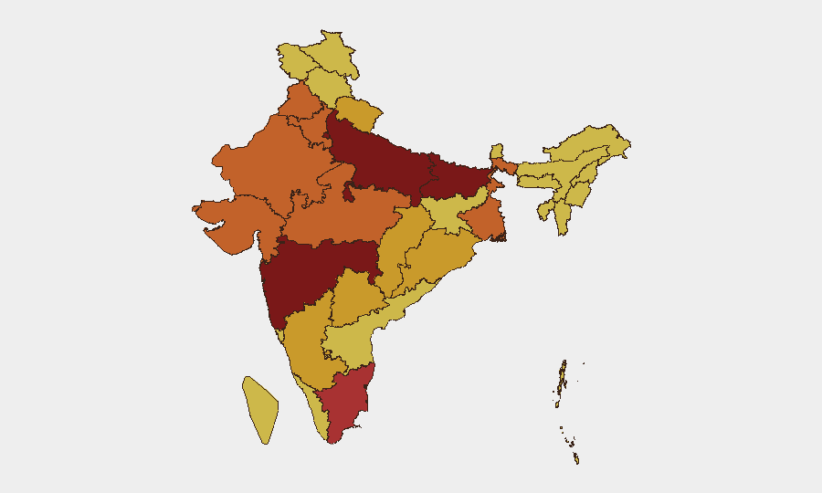
India remains the highest-ranked threat environment globally (composite score 100; 1,796 tracked events), driven by persistent cyber-crime, civil unrest, environmental hazards, and isolated militant activity across multiple states. Maharashtra, Delhi, and Uttar Pradesh constitute the primary risk concentration, accounting for sustained criminal, cyber, and civil-order incidents. Near-term trajectory is volatile but not acutely destabilizing; however, monsoon-driven environmental hazards now compound transport and operational risk across the Northeast, while cyber-attacks on critical infrastructure and supply chains (notably Bajaj Auto) signal rising digital-threat vectors for corporates nationwide.
Key Developments
- Barpeta district, Assam (June 23): Two teenage boys killed after being struck by a train, prompting renewed safety concerns on regional rail networks during onset of monsoon season.
- Kachua, Nagaon district, Assam (June 23): Drowning of two young children reported; water-safety risks are elevated across the region during heavy rains.
- Keyi Panyor district, Arunachal Pradesh (June 24): Flash floods triggered by heavy morning rainfall inundated Possa Village and NEFCO Colony, damaging 15+ residential structures and severing transport connectivity; secondary threat to downstream communities through June 25.
- Lower Subansiri–Assam corridor (June 24–25): Intense rainfall and flash floods in Arunachal Pradesh's Lower Subansiri area have prompted multi-district flood alerts in Assam; authorities warn of adverse conditions over next 24–48 hours, affecting road/rail transit and critical supply routes.
- Delhi, National Capital Territory (June 24): Delhi Police arrested a foreign national (Ivory Coast) and local partner for operating a cyber-fraud scheme targeting women via matrimonial websites, underscoring persistent cyber-crime risk in the capital and national digital infrastructure.
- Pune/Maharashtra (June 24): Bajaj Auto, a major automotive manufacturer, disclosed a ransomware attack affecting operations and technology functions; indicates elevated cyber-security risk across the automotive supply chain and broader industrial base.
- Tripura (June 24): Two militant-affiliated organizations withdrew an announced indefinite rail and road blockade after government assurances, reducing near-term transport disruption risk across the state's networks.
Highest-Risk Areas
Maharashtra (100), Delhi (87.6), and Uttar Pradesh (84.4) drive composite threat risk due to concentration of cyber-crime infrastructure, high-volume civil unrest, and organized criminal activity. Bihar (80.6) and Tamil Nadu (76.3) follow, reflecting communal tensions, student-led agitation, and maritime/border-adjacent vulnerabilities. The Northeast corridor (Assam, Arunachal Pradesh, Tripura) has emerged as an acute secondary-risk zone due to monsoon-driven environmental hazards, militant-group activity signaling, and transport network fragility. Corporate and expatriate populations should prioritize risk monitoring in Maharashtra and Delhi; supply-chain and logistics operations require heightened cyber-resilience protocols across all major metros.
How GeoBit Would Assist
Security teams should deploy AOI Monitoring & Early Warning on Maharashtra, Delhi, and key Northeast transport corridors to detect emerging civil unrest, environmental incidents, and supply-chain disruptions in real time. Intel Sweep and multi-language OSINT fusion (including X/Telegram monitoring) enable early detection of cyber-threat actor activity targeting Indian corporates and operational networks. Routing & Network Analysis capabilities allow duty-of-care teams to identify alternative transport routes and contingency supply chains around high-risk zones and monsoon-affected infrastructure.
7-Day Outlook
Monsoon intensity will likely sustain elevated environmental and transport risk across the Northeast through late June; flash-flood and rail-safety incidents should be expected. Cyber-attack frequency against Indian corporates and financial institutions may increase as threat actors exploit operational disruption caused by weather and logistical delays. Civil-order incidents and community demands (per recent event signals) will persist in Maharashtra, Delhi, and Uttar Pradesh, but do not signal imminent large-scale unrest.
Highest-Risk Areas — Ranked
| # | State / Region | Risk |
|---|---|---|
| 1 | Maharashtra | 100 |
| 2 | Delhi | 87.6 |
| 3 | Uttar Pradesh | 84.4 |
| 4 | Bihar | 80.6 |
| 5 | Tamil Nadu | 76.3 |
| 6 | Gujarat | 75.8 |
| 7 | Madhya Pradesh | 74.8 |
| 8 | Punjab | 74.7 |
| 9 | West Bengal | 74.5 |
| 10 | Haryana | 73.3 |
| 11 | Rajasthan | 73.1 |
| 12 | Karnataka | 72.3 |
Sources
Previous Daily Briefs
A new India brief is written every day — each with its own risk map and downloadable CSV. Here's the last week; use the calendar to go further back.
📅 Browse every day by calendar →
Highlighted days have a brief. Tap a day for that day's map & analysis, or “csv” for that day's dataset ($5).