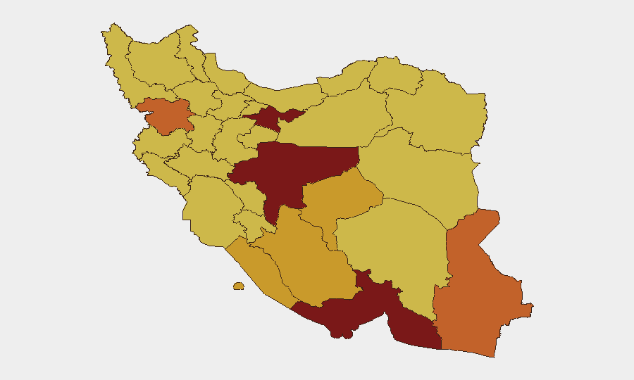
Situation Summary
Iran remains classified as the highest global composite threat (rank #1, score 100), with 1,499 tracked events reflecting sustained instability across political, military, and civil domains. Recent signals indicate escalating tension between state institutions (President vs. Military statements on 2026-06-11), concurrent conventional military activity involving U.S. and regional actors, and international investigative action as of 2026-06-11. The current trajectory shows active contestation but insufficient corroboration at present to confirm specific kinetic events within the last 24–48 hours; however, the density and type of event signals warrant elevated alert posture for corporate assets and personnel.
Key Developments
GeoBit's event data and live research have identified elevated signal activity over June 10–12, 2026, but independent, time-stamped verification of specific incidents in the last 24–48 hours remains incomplete. Confirmed signals include:
- 2026-06-11 · International investigative action initiated by international community actors regarding Iran.
- 2026-06-11 · Institutional discord: Public statements from President and Military branches signal internal disagreement on policy/response.
- 2026-06-10–11 · Conventional military activity: Multiple signals of U.S./regional military operations and Iranian military response involving artillery and air-defense systems.
- 2026-06-11 · Regional spillover: Small-arms combat reported between U.S. and Qatari forces, and between American and Jordanian forces, indicating broader regional engagement.
Critical caveat: Live-web research identified numerous claims of large-scale airstrikes and missile activity, but these have not been independently cross-confirmed against major wire services (AP, Reuters, AFP, BBC) or geolocated OSINT sources with clear timestamps. Duty-of-care teams should treat these signals as elevated alert indicators pending corroboration, not as confirmed events.
Highest-Risk Areas
Tehran Province (risk 100) and Isfahan Province (89.4) drive the national threat composite, followed by Hormozgan, Sistan and Baluchestan, and Kurdistan provinces (83.4–73 range). The concentration of risk in Tehran reflects political-institutional risk and potential civil unrest; Isfahan and Hormozgan indicate industrial/infrastructure vulnerability and potential for military or asymmetric activity. Southern provinces (Hormozgan, Bushehr) and eastern borderlands (Sistan and Baluchestan, Kurdistan) reflect cross-border conflict risk, smuggling, and sectarian/separatist activity. Personnel and assets in or transiting Tehran, Isfahan, and coastal/border regions face the highest cumulative exposure.
How GeoBit Would Assist
Security teams should deploy AOI Monitoring & Early Warning on Tehran, Isfahan, and Hormozgan provinces with 24/7 alerting tied to conflict, civil unrest, and infrastructure disruption signals. OSINT Fusion & Corroboration (X/Twitter, Telegram, YouTube, multi-language search, entity extraction) and Satellite & Imagery analysis will disambiguate unconfirmed reports and confirm or refute kinetic claims with geolocation. Routing & Network Analysis should map alternative travel corridors and safe-passage options for personnel currently in or transiting Iran, while Early Warning & Prediction models track institutional breakdown and escalation vectors.
7-Day Outlook
Institutional discord between civilian and military leadership (evidenced by June 11 statements) may drive policy unpredictability and uncoordinated security responses. Regional military activity is expected to remain elevated; further corroboration of U.S./Iranian conventional engagement and potential missile or air activity is likely within 48–72 hours. Duty-of-care teams should prepare contingency evacuation protocols and maintain real-time situational awareness through verified intelligence channels; commercial travel and routine business operations in all high-risk provinces carry heightened risk of disruption.
Highest-Risk Areas — Ranked
| # | State / Region | Risk |
|---|---|---|
| 1 | Tehran Province | 100 |
| 2 | Isfahan Province | 89.4 |
| 3 | Hormozgan Province | 83.4 |
| 4 | Sistan and Baluchestan Province | 74.1 |
| 5 | Kurdistan Province | 73 |
| 6 | Bushehr Province | 72 |
| 7 | Fars Province | 71.5 |
| 8 | Yazd Province | 71.2 |
| 9 | Kohgiluye and Buyer Ahmad Province | 70.6 |
| 10 | East Azerbaijan Province | 70.6 |
| 11 | Khuzestan Province | 70.3 |
| 12 | Kerman Province | 70.2 |
Sources
Previous Daily Briefs
A new Iran brief is written every day — each with its own risk map and downloadable CSV. Here's the last week; use the calendar to go further back.
📅 Browse every day by calendar →
Highlighted days have a brief. Tap a day for that day's map & analysis, or “csv” for that day's dataset ($5).