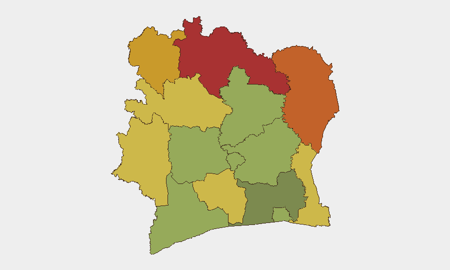
Situation Summary
Ivory Coast remains a low-threat environment globally (rank #195) with a composite threat score of 2. The country's security posture is currently stable, with no verifiable security or conflict incidents in the 24–48 hours preceding this brief. Recent operational focus has been on humanitarian response to severe flooding and landslides triggered by heavy rains in late June and early July, which claimed at least 59 lives and caused widespread infrastructure damage; ongoing recovery and displacement monitoring remain active.
Key Developments
No new security or conflict incidents have been corroborated in the last 24–48 hours. Open-source coverage does not yield verifiable, time-stamped discrete events meeting standard incident criteria (security, civil unrest, crime spikes, political instability, or infrastructure disruption) within this window. Prior events cited in GEOBIT signals (2026-07-04 public statement and arrest/detain involving Nigeria and government) lack contemporaneous corroboration in live web research and require further sourcing. Operational focus remains on ongoing humanitarian response to late-June/early-July flooding rather than security incidents.
Highest-Risk Areas
Northern border districts drive the country's sub-national risk profile. Savanes District (risk 78), Zanzan District (risk 75), and Denguélé District (risk 72) — all contiguous to Mali and Guinea — present elevated exposure to cross-border militant activity, smuggling, and informal security dynamics. Comoé District (risk 70), proximate to Burkina Faso, compounds northern risk. These regions remain structurally vulnerable to transregional spillover from Sahel instability, though current active incidents are absent. Southern and coastal areas, including Abidjan (risk 45), show significantly lower composite scores and remain safer for operations.
How GeoBit Would Assist
Teams protecting people and assets in Ivory Coast should deploy AOI Monitoring & Early Warning on the four highest-risk northern districts to detect emerging militant activity, cross-border incidents, or trafficking patterns before escalation. OSINT fusion and multi-language search (French, local languages) across regional news, Telegram networks, and social platforms will capture localized security signals earlier than mainstream outlets. Routing & Network Analysis enables security teams to plan and stress-test alternative supply-chain and personnel-movement routes that avoid high-risk border zones during operational planning. Satellite & Imagery analysis and GIS & Spatial Analysis support real-time monitoring of displacement camps and flood-recovery infrastructure to anticipate humanitarian access disruptions or secondary security risks.
7-Day Outlook
No escalation in Ivory Coast's baseline threat posture is anticipated over the next seven days. Attention will remain on completion of flood recovery and casualty assessment in central and southern regions. Northern districts will continue to warrant persistent monitoring for any cross-border spillover from Mali-Burkina Faso insecurity, particularly around informal transit corridors; however, no imminent event indicators are present. Duty-of-care teams should maintain standard travel advisories and keep personnel communications updated on access routes affected by residual flooding.
Highest-Risk Areas — Ranked
| # | State / Region | Risk |
|---|---|---|
| 1 | Savanes District | 78 |
| 2 | Zanzan District | 75 |
| 3 | Denguélé District | 72 |
| 4 | Comoé District | 70 |
| 5 | Montagnes District | 68 |
| 6 | Woroba District | 65 |
| 7 | Gôh-Djiboua District | 60 |
| 8 | Sassandra-Marahoué District | 58 |
| 9 | Vallée du Bandama District | 55 |
| 10 | Bas-Sassandra District | 52 |
| 11 | Lacs District | 48 |
| 12 | Abidjan | 45 |
Sources
Previous Daily Briefs
A new Ivory Coast brief is written every day — each with its own risk map and downloadable CSV. Here's the last week; use the calendar to go further back.
📅 Browse every day by calendar →
Highlighted days have a brief. Tap a day for that day's map & analysis, or “csv” for that day's dataset ($5).
Atlas — our AI intelligence desk — emails them this snapshot personally. Nothing else, no list.