Situation Summary
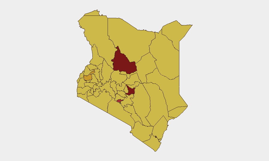
Kenya's composite threat score of 96 (rank #17 globally) reflects a volatile security environment driven by political instability, localized armed conflict, and emerging cyber threats. The last 48 hours have seen a high-profile cyberattack on the presidency, politically motivated violence disrupting electoral processes, and ongoing militant pressure in northeastern border regions. The threat trajectory remains elevated and unpredictable across multiple domains—cyber, civil unrest, and terrorism—with geographic concentration in pastoral and opposition-stronghold counties.
Key Developments
- Nairobi (President's official website), 18 July 2026 – Cyberattack and defacement of president.go.ke, including ransom demand (5 BTC); ICT Authority and NC4 launched forensic investigation; no confirmed data breach reported.
- Ol Kalou, Nyandarua County (AC Primary polling station), 18 July 2026 – Armed, masked assailants in SUVs deployed teargas and physically assaulted Nation Media Group journalists during by-election polling; camera seized, staff tasered; indicators of political coordination.
- Mandera Central Sub-County (Irresuki security camp), 22 June 2026 – Kenya Defence Forces repulsed coordinated Al-Shabaab assault; no KDF casualties reported; attackers withdrew with probable injuries (blood trails observed).
Highest-Risk Areas
Samburu County (risk 97.5) leads the sub-national ranking, driven by pastoral resource conflicts and cross-border militant activity; Embu (83.6) and Nairobi County (78.9) reflect a mix of inter-communal violence, organized crime, and political volatility. The northern pastoral belt (Samburu, Laikipia, Isiolo) faces sustained Al-Shabaab and raider pressure; Nairobi's ranking reflects both terrorism risk and acute political instability, as evidenced by the cyberattack on state institutions and election-day disruptions. Western counties (Kakamega, Busia, Vihiga, Nandi) score elevated risk tied to historical political tensions and organized criminal networks. Corporate assets and personnel should prioritize Nairobi situational awareness and avoid Samburu/Isiolo travel without hardened security protocols.
How GeoBit Would Assist
Security teams should deploy AOI Monitoring & Early Warning on Nairobi political and critical-infrastructure nodes (government buildings, media offices, telecoms) to detect pre-incident anomalies and protest mobilization; couple with X/Twitter & Telegram OSINT and sentiment analysis to track political narratives and incitement in real time. Cyber threat intelligence and Shodan scanning of Kenya's government and corporate digital perimeter would identify vulnerable endpoints and persistent-threat activity. Election monitoring capability and conflict mapping of Nyandarua and western counties enable advance routing and staff safety protocols around electoral flashpoints.
7-Day Outlook
Political tensions are likely to remain elevated through any ongoing electoral cycles, with repeated instances of poll-day violence and cyber harassment of state targets. Al-Shabaab pressure on northeastern security forces is expected to persist; localized pastoral conflicts will likely spike in Samburu and Laikipia as dry-season resource scarcity peaks. Corporate entities should expect continued targeting of digital infrastructure and media operations; alternative comms and offline protocols recommended for high-risk locations.
Highest-Risk Areas — Ranked
| # | State / Region | Risk |
|---|---|---|
| 1 | Samburu | 97.5 |
| 2 | Embu | 83.6 |
| 3 | Nairobi County | 78.9 |
| 4 | Kakamega County | 71.4 |
| 5 | Nakuru | 70.3 |
| 6 | Kiambu | 69.1 |
| 7 | Laikipia County | 68.6 |
| 8 | Nyeri | 68.6 |
| 9 | Isiolo | 68 |
| 10 | Busia County | 67.5 |
| 11 | Vihiga County | 67.5 |
| 12 | Nandi County | 67.5 |
Sources
Previous Daily Briefs
A new Kenya brief is written every day — each with its own risk map and downloadable CSV. Here's the last week; use the calendar to go further back.
📅 Browse every day by calendar →
Highlighted days have a brief. Tap a day for that day's map & analysis, or “csv” for that day's dataset ($5).
Atlas — our AI intelligence desk — emails them this snapshot personally. Nothing else, no list.