Situation Summary
Kenya is experiencing a critical convergence of labour unrest, public-order disruption, and cyber-security incidents that have fractured essential services and mobility across multiple counties. A nationwide matatu strike (now in its second day) and healthcare worker strike have immobilized transport and medical care, while fuel-related protests have triggered violent clashes with police resulting in multiple fatalities and hundreds of arrests. Concurrent political tensions, localized violent crime, and a confirmed breach of the President's official website signal widening systemic vulnerability across security, governance, and critical infrastructure domains.
Key Developments
- Nairobi CBD & transport hubs (Roysambu, Githurai, Outer Ring Road, Thika Road junctions) – 22 July
Day-two nationwide matatu strike caused severe commuter disruption; heavy police presence maintained after fuel-protest clashes on 21 July that killed four persons and resulted in hundreds of arrests.
- Ruiru Bypass, near Kihunguro, Kiambu County – 22 July
Fresh youth-police clashes occurred with protesters erecting stone and tyre barricades amid ongoing transport and fuel strikes; police deployed anti-riot units.
- Multi-county impact (Kiambu, Machakos, Kajiado, Murang'a, Mombasa, Kisumu) – 22 July
Matatu strike and transport disruption spread beyond Nairobi, affecting public transport, taxis, boda-bodas, and cargo movement; Kenya Red Cross coordinating response.
- Nationwide health facilities – Night of 21–22 July
Healthcare services paralyzed by nationwide medical practitioners' strike over government failure to absorb Universal Health Coverage staff into permanent positions; hospital operational capacity degraded.
- Nyando Sub-county, Kisumu County – 22 July
Violent clash at relief food distribution site resulted in one fatality (32-year-old male stabbed) and multiple injuries; police responded.
- Ol Kalou Constituency, Nyandarua County – Investigations ongoing, 22 July
Directorate of Criminal Investigations and Interior CS opened probe into alleged political violence during 20 July by-election, including reports of armed, hooded individuals and hired goons; ongoing political-security concern.
- President William Ruto's official website (president.go.ke) – Incident revealed 18–22 July
Cyberattack confirmed; website defaced and access restricted; national cybersecurity protocols activated; forensic investigation underway with no evidence of sensitive data exfiltration reported to date.
- Spring Valley, Nairobi County – 22 July
Three additional suspects arrested in connection with armed robbery at Chaiiwali Restaurant; heightened law-enforcement response to organized crime in CBD vicinity.
Highest-Risk Areas
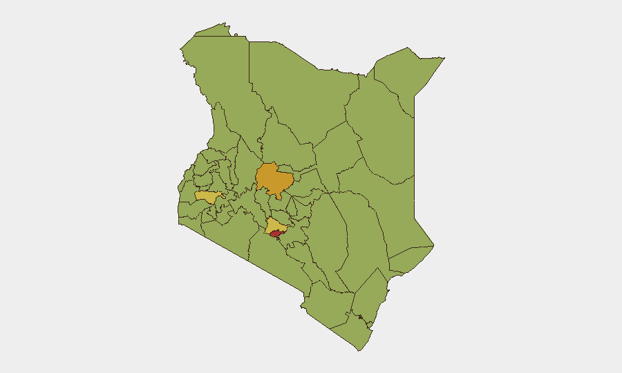
Nairobi County (79.8) and Laikipia County (72.3) dominate the risk profile, driven by the capital's dense convergence of transport disruption, violent protest activity, and organized crime, while Laikipia faces elevated herding-related conflict and cattle rustling pressures. Secondary concern areas—Kisumu (64.8), Kiambu (64.8), and Isiolo (59.8)—show heightened risk from labour unrest spillover, localized political violence, and resource-competition dynamics. Northern pastoral counties (Garissa, Isiolo) remain vulnerable to intercommunal tension and banditry; western counties (Kisumu, Busia, Bungoma) show activism and service-delivery protests typical of opposition strongholds.
How GeoBit Would Assist
Security teams should activate AOI Monitoring & Early Warning on Nairobi CBD, Kiambu transport corridors, and health-facility clusters to detect escalation signals in real time. OSINT fusion (X/Twitter, Telegram, local news feeds, YouTube) combined with sentiment & temporal analysis will track protest coordination, labour union messaging, and incitement narratives. Routing & Network Analysis can supply real-time alternative journey planning as transport corridors remain disrupted.
7-Day Outlook
The matatu and healthcare strikes are likely to persist through mid-week absent negotiated settlement, prolonging supply-chain fragmentation and raising accident/medical-emergency response risks. Political tensions from the Ol Kalou by-election and localized goon deployment allegations may sustain localized violence in Nyandarua and Kiambu; monitor for copycat violence in other opposition zones. Cyber-incident containment and remediation of the presidential website will take days; similar critical-infrastructure probing should be anticipated.
Highest-Risk Areas — Ranked
| # | State / Region | Risk |
|---|---|---|
| 1 | Nairobi County | 79.8 |
| 2 | Laikipia County | 72.3 |
| 3 | Kisumu County | 64.8 |
| 4 | Kiambu | 64.8 |
| 5 | Busia County | 59.8 |
| 6 | Isiolo | 59.8 |
| 7 | Uasin Gishu County | 54.8 |
| 8 | Kisii County | 54.8 |
| 9 | Murang'a County | 54.8 |
| 10 | Garissa | 54.8 |
| 11 | Bungoma County | 54.8 |
| 12 | Kakamega County | 49.8 |
Sources
Previous Daily Briefs
A new Kenya brief is written every day — each with its own risk map and downloadable CSV. Here's the last week; use the calendar to go further back.
📅 Browse every day by calendar →
Highlighted days have a brief. Tap a day for that day's map & analysis, or “csv” for that day's dataset ($5).
Atlas — our AI intelligence desk — emails them this snapshot personally. Nothing else, no list.