Situation Summary
Lebanon remains in active conflict with Israel, driven by intensive cross-border military operations, airstrikes, and ground combat concentrated in the south and Beqaa Valley. The past 48 hours have seen confirmed airstrikes on civilian areas (Tyre), UNIFIL reporting direct engagement near peacekeeping positions, Israeli displacement orders affecting ~1,900 civilians, and unconfirmed claims of 150+ Hezbollah site strikes. Risk trajectory is escalating, with military strikes dominating the threat signal and territorial occupation/control dynamics intensifying.
Key Developments
- Tyre, South Governorate — 13 June: Airstrikes killed at least 11 people and injured 44 in the city; UN sources attributed strikes to Israeli air operations in intensive southern Lebanon campaign.
- West of Kleyaa, Sector East — 13 June: UNIFIL reported intense ground combat near a checkpoint, with armed personnel firing from residential buildings, artillery, drone detonations, and airstrikes forcing peacekeepers to shelter; checkpoint sustained damage but no UNIFIL casualties.
- Marjayoun area, Sector East — 13 June: UNIFIL EOD teams discovered and safely neutralized a grenade and drone near a position's main gate.
- Tyre area displacement — 13 June: Israeli military issued displacement orders affecting Tyre and surrounding localities; UNIFIL cancelled six planned humanitarian missions as a result.
- Nabatieh and South Governorate — 13 June: Israeli army displacement orders issued for three localities, affecting approximately 1,900 civilians.
- Southern Lebanon airstrike claims — 13 June: Israeli military claimed ~150 Hezbollah site strikes across southern Lebanon in the preceding 48 hours (single-source; requires cross-verification).
Highest-Risk Areas
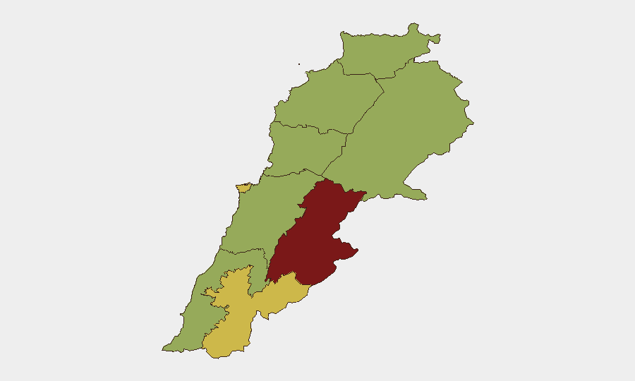
Beqaa Governorate (85.8) and Beirut Governorate (66.7) drive the highest composite risk, followed closely by Nabatieh and South Governorate (both 62–58.6). The Beqaa concentration reflects ongoing military strike activity and unconventional violence, while Beirut's elevation reflects proximity to command-and-control nodes and secondary effects of broader conflict. South and Nabatieh governorates remain hotspots for ground combat, airstrikes, and displacement orders. Personnel and assets in Beqaa should be regarded as highest-priority for relocation or hardening; southern operations face acute tactical risk from ongoing air operations and IDF ground presence.
How GeoBit Would Assist
Security teams should leverage AOI Monitoring & Early Warning to establish persistent watch on Beqaa, Tyre, and Marjayoun zones with automated alerting on military activity, displacement orders, and airstrike patterns. Battle mapping, force structure, and weapons-capability tracking would enable real-time assessment of Israeli and Lebanese military positions, airspace control, and strike radius. OSINT fusion across X/Telegram, news feeds, and UNIFIL statements provides corroboration of incident claims and distinguishes confirmed events from single-source assertions—critical for duty-of-care decisions on staff movement and asset protection.
7-Day Outlook
Intensity is likely to remain elevated or increase over the next seven days, with military strike frequency and territorial control dynamics as the primary escalation drivers. Displacement orders may expand geographically, compounding civilian harm and further constraining humanitarian access. Organizations with personnel in Beqaa, South, and Nabatieh should expect sustained constraints on movement and heightened risk of indirect effects (secondary strikes, collateral damage); contingency evacuation and supply-chain diversification are operationally warranted.
Highest-Risk Areas — Ranked
| # | State / Region | Risk |
|---|---|---|
| 1 | Beqaa Governorate | 85.8 |
| 2 | Beirut Governorate | 66.7 |
| 3 | Nabatieh Governorate | 62 |
| 4 | South Governorate | 58.6 |
| 5 | North Governorate | 55.8 |
| 6 | Akkar Governorate | 55.8 |
| 7 | Keserwan-Jbeil Governorate | 55.8 |
| 8 | Mount Lebanon Governorate | 55.8 |
| 9 | Baalbek-Hermel Governorate | 55.8 |
Sources
Previous Daily Briefs
A new Lebanon brief is written every day — each with its own risk map and downloadable CSV. Here's the last week; use the calendar to go further back.
📅 Browse every day by calendar →
Highlighted days have a brief. Tap a day for that day's map & analysis, or “csv” for that day's dataset ($5).