Situation Summary
Lesotho presents a low acute security profile with no verified incidents reported within its borders in the last 24–48 hours. However, sub-national risk concentration in Maseru District (78) and surrounding urban/peri-urban zones reflects chronic vulnerabilities in policing capacity, organized crime, and cross-border criminal networks. Regional dynamics—particularly heavy Lesotho national involvement in South African illegal mining and ATM-bombing operations—indicate sustained transnational criminal activity affecting nationals and potentially destabilizing remittance-dependent border communities. The overall threat environment remains stable but fragmented by localized governance and socioeconomic friction.
Key Developments
- No discrete security, conflict, civil-unrest, or crime incidents confirmed within Lesotho territory in the last 24–48 hours across open-source, X/Twitter, and regional security feeds.
- South Africa (regional context): A 52-year-old Lesotho national was arrested near Rustenburg, North West Province (20 July 2026) with dye-stained banknotes linked to ATM bombings in the Bojanala Platinum District; implications for cross-border criminal networks and Lesotho-origin organized crime supply chains are noted, though the incident occurred outside Lesotho.
- South Africa (regional context): Illegal mining operations west of Johannesburg (mid-July 2026) arrested over 100 Lesotho nationals among 200+ apprehended; two South African soldiers died during enforcement operations. This reflects sustained labor trafficking and criminal recruitment flows from Lesotho into South African illicit extraction networks.
- No infrastructure, political instability, or civil unrest reported in-country for the current 24–48-hour window.
Highest-Risk Areas
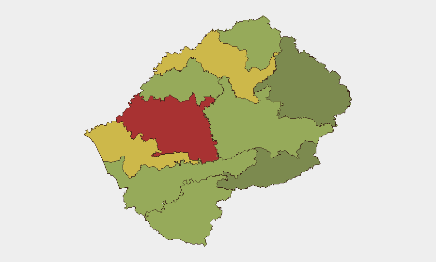
Maseru District dominates the risk landscape (78), reflecting the capital's concentration of formal economy, transactional crime, and organized criminal presence. Mafeteng (65) and Leribe (62) districts follow, driven by border proximity to South Africa, informal cross-border trade, and limited police presence. These three districts collectively account for the majority of domestic crime, narcotics transit, and financial crime. Southern and eastern highland districts (Qacha's Nek, Mokhotlong) show substantially lower scores (28–38), reflecting geographic remoteness and lower criminal infrastructure density, though cattle rustling and subsistence-level crime remain endemic.
How GeoBit Would Assist
Teams with Lesotho exposure should deploy AOI Monitoring & Early Warning on Maseru and Mafeteng districts to detect civil unrest, political signaling, or security-force mobilization; Network & Actor Analysis to map Lesotho nationals and criminal cells engaged in regional illegal mining and ATM operations, enabling duty-of-care assessments for staff; and Routing & Network Analysis to identify safe transit corridors and alternative journeys during periods of border or cross-district instability. Intel Sweep and X/Twitter OSINT remain the primary early-warning tools for detecting rapid deterioration signals.
7-Day Outlook
No significant change in the current low-acute-incident trajectory is anticipated over the next 7 days. Chronic risks—cross-border crime, police capacity constraints, and informal-economy instability—will persist. Teams should maintain standard duty-of-care protocols and monitor for any abrupt political signaling, police strikes, or South African security operations that might trigger secondary Lesotho-side disruption.
Highest-Risk Areas — Ranked
| # | State / Region | Risk |
|---|---|---|
| 1 | Maseru District | 78 |
| 2 | Mafeteng District | 65 |
| 3 | Leribe District | 62 |
| 4 | Berea District | 58 |
| 5 | Mohale's Hoek District | 52 |
| 6 | Butha-Buthe District | 48 |
| 7 | Thaba-Tseka District | 45 |
| 8 | Quthing District | 42 |
| 9 | Mokhotlong District | 38 |
| 10 | Qacha's Nek District | 28 |
Sources
Previous Daily Briefs
A new Lesotho brief is written every day — each with its own risk map and downloadable CSV. Here's the last week; use the calendar to go further back.
📅 Browse every day by calendar →
Highlighted days have a brief. Tap a day for that day's map & analysis, or “csv” for that day's dataset ($5).
Atlas — our AI intelligence desk — emails them this snapshot personally. Nothing else, no list.