Situation Summary
Lithuania faces elevated but stable critical-infrastructure risk following coordinated intelligence warnings and military deployments on 6–7 August. Russian threat actors are assessed to be considering false-flag drone operations using captured Ukrainian systems against NATO eastern-flank targets; Lithuanian officials have confirmed the intelligence credibility but stated no imminent attack indicators are present. The threat environment remains operationally unchanged from prior weeks, though defensive posture has visibly hardened across energy, aviation, and port sectors.
Key Developments
- Vilnius International Airport | 2026-08-06 — Overnight operational halt following airspace incursion by suspected smuggler balloons originating from Belarus; infrastructure was restored but incident underscores perimeter vulnerability.
- Klaipėda LNG Terminal | 2026-08-06 — Armed forces deployed and security perimeter tightened in response to intelligence warning of potential hostile activity; status remains under heightened protection.
- Alytus District (LitPol Link/Transformer Substation) | 2026-08-06 — Military asset protection reinforced following credible threat assessment; critical energy corridor now under active armed guard.
- Kruonis Power Plant | 2026-08-06 — Armed personnel positioned and security envelope expanded in line with regional critical-infrastructure alert; no incident reported.
- Vilnius | 2026-08-07 — Lithuanian Defence Minister Robertas Kaunas publicly stated intelligence assessment that Russia may employ captured Ukrainian drones in false-flag strikes against Baltic critical infrastructure; Prime Minister Sinkevičius clarified threat level has not materially escalated and no imminent attack is indicated.
- Vilnius | 2026-08-06 — Authorities charged 13 individuals in connection with alleged GRU-linked attempted-murder cases; investigation predates recent warning activity but reflects ongoing Russian clandestine-operation footprint in capital.
- Southern Lithuania | 2026-08-07 — Severe storms caused structural damage and tree falls; no casualties reported in available summary but secondary effects on road/power infrastructure possible.
Highest-Risk Areas
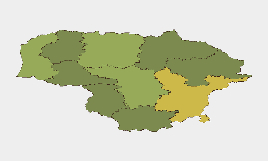
Vilnius County (risk 68) and Kaunas County (risk 58) drive national risk, with Vilnius's capital status attracting both state-level clandestine activity (GRU networks, drone staging) and critical infrastructure (airport, government, energy substations). Klaipėda County (risk 52) ranks third due to its role as NATO's primary LNG import hub and deep-water port—assets of direct Russian targeting interest. Siauliai, Panevėžys, and Tauragė counties show moderate risk scores (42, 38, 35) reflecting secondary energy and logistics nodes; lower-ranked counties pose minimal organizational security concern absent localized incidents.
How GeoBit Would Assist
Security teams should deploy AOI Monitoring & Early Warning on Vilnius airport, LNG terminal, Kruonis plant, and Alytus substations to detect perimeter breaches, vehicle/drone approach, or infrastructure anomalies in near-real time. Maritime & Aviation Tracking combined with Satellite & Imagery Analysis would establish baseline detection of balloon/drone incursions and vessel activity in Klaipėda approaches. Intel Sweep and X/Telegram OSINT would surface GRU operational chatter, false-flag narrative seeding, and coordination signals 72–96 hours ahead of execution, enabling duty-of-care escalation before attack.
7-Day Outlook
Russian threat signaling is likely to persist through mid-August, with incremental defensive measures (air-defense posturing, perimeter hardening) expected to remain in place across energy and maritime assets. Absent kinetic escalation or NATO Article 5 activation, corporate operations will continue under yellow-alert protocols; drone or sabotage incidents remain credible but not imminent based on current intelligence consensus.
Highest-Risk Areas — Ranked
| # | State / Region | Risk |
|---|---|---|
| 1 | Vilnius County | 68 |
| 2 | Kaunas County | 58 |
| 3 | Klaipeda County | 52 |
| 4 | Siauliai County | 42 |
| 5 | Panevezys County | 38 |
| 6 | Taurage County | 35 |
| 7 | Utena County | 33 |
| 8 | Alytus County | 32 |
| 9 | Telsiai County | 28 |
| 10 | Marijampole County | 25 |
Sources
Previous Daily Briefs
A new Lithuania brief is written every day — each with its own risk map and downloadable CSV. Here's the last week; use the calendar to go further back.
📅 Browse every day by calendar →
Highlighted days have a brief. Tap a day for that day's map & analysis, or “csv” for that day's dataset ($5).
Atlas — our AI intelligence desk — emails them this snapshot personally. Nothing else, no list.