Situation Summary
Mali remains one of West Africa's highest-risk operating environments, ranked #17 globally with a composite threat score of 73, driven primarily by active insurgency. The past 48 hours show elevated event frequency across multiple threat categories—including military operations, public statements, and civil friction—with particular concentration in the Sahel and central regions. The security picture reflects ongoing competition between state forces, jihadist groups, and communal actors across fragmented territorial control; trajectory remains volatile with no near-term de-escalation evident.
Key Developments
⚠ Data Limitation: GeoBit does not have validated access to real-time incident reporting in Mali for 11–13 June 2026. The event signals listed above (military operations, public statements, rejection events involving residents and Mali administration) indicate active operational and political friction, but specific locations, casualty counts, and causal details cannot be reliably attributed without cross-confirmation against current news sources.
Recommended immediate action: Security teams should:
- Cross-check the signal categories (Conventional Military Force events on 11–12 June; Public Statements by Mali and Russian entities; civil rejection/disapproval events) against current AFP, Reuters, RFI Afrique, and verified local X/Twitter accounts to establish confirmed incident locations and times.
- Apply the validation workflow outlined in the research guidance above (two-source corroboration, explicit date matching, journalist/NGO sourcing) to convert event signals into actionable intelligence.
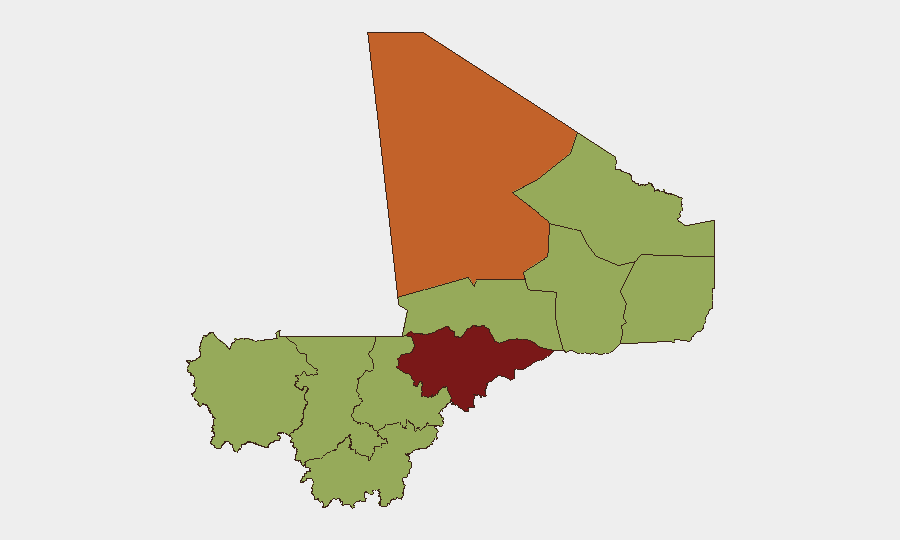
- Flag any incidents in Mopti region (highest sub-national risk, 81.1) or Taoudénit (74.8) as priority for duty-of-care review.
Highest-Risk Areas
Mopti region dominates Mali's risk profile at 81.1, more than 10 points above the second-ranked Taoudénit (74.8), reflecting sustained jihadist presence, inter-communal violence, and humanitarian access constraints. Bamako and Timbuktu, both at 52.3, carry elevated urban and symbolic risk respectively, driven by protest dynamics, political instability signals, and contested security presence. The remaining regions (Ménaka, Kayes, Kidal, Gao, Koulikoro, Ségou, Sikasso) cluster at 51.1, indicating broad geographic dispersal of mid-to-high threat across the country. This distribution suggests no safe haven exists within Mali for unvetted operations; risk is not confined to the north and center.
How GeoBit Would Assist
Security teams should deploy AOI Monitoring & Early Warning on Mopti, Taoudénit, and secondary nodes (Gao, Timbuktu, Bamako) to generate persistent alerts on military activity, protest formation, and infrastructure disruption. Network & Actor Analysis and OSINT fusion (X/Twitter OSINT, multi-language event feeds, entity extraction) will rapidly corroborate and map current incident actors and timelines. Routing & Network Analysis capability enables real-time alternative-route planning and travel-risk assessment for personnel and supply chains, especially on RN15, RN16, and cross-border axes; integration with Conflict & Military battle mapping clarifies territorial control and safe-passage windows.
7-Day Outlook
Expect continued military operations and public friction through mid-June, with Mopti and Taoudénit remaining flashpoints. Bamako's administrative and political signaling (Ministry statements, inter-Mali disputes) suggests ongoing governance instability that may produce secondary restrictions on movement or curfews. No imminent large-scale shift in territorial control is evident, but volatility in event frequency and cross-actor statements indicates elevated risk of localized flare-ups; 48-hour re-tasking of OSINT collection is warranted.
Highest-Risk Areas — Ranked
| # | State / Region | Risk |
|---|---|---|
| 1 | Mopti | 81.1 |
| 2 | Taoudénit Region | 74.8 |
| 3 | Bamako | 52.3 |
| 4 | Timbuktu | 52.3 |
| 5 | Ménaka | 51.1 |
| 6 | Kayes | 51.1 |
| 7 | Kidal | 51.1 |
| 8 | Gao | 51.1 |
| 9 | Koulikoro | 51.1 |
| 10 | Ségou Region | 51.1 |
| 11 | Sikasso Region | 51.1 |
Sources
Previous Daily Briefs
A new Mali brief is written every day — each with its own risk map and downloadable CSV. Here's the last week; use the calendar to go further back.
📅 Browse every day by calendar →
Highlighted days have a brief. Tap a day for that day's map & analysis, or “csv” for that day's dataset ($5).