Situation Summary
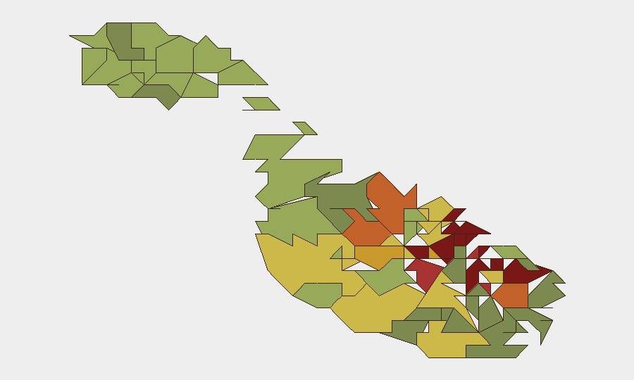
Malta's security environment remains stable overall, with a composite threat score of 4 and no tracked discrete security events in the current analysis window. However, recent incidents—including a fireworks factory explosion, an abandoned building fire, and ongoing high-profile legal proceedings involving political threats—reflect persistent underlying vulnerabilities in industrial safety, emergency response, and politically motivated risk. The concentration of risk in the capital region (Valletta, Sliema, Saint Julian's) and surrounding urban areas suggests exposure is primarily localized to population centers and commercial zones rather than systemic national instability.
Key Developments
- Salini–Magħtab fireworks factory explosion (August 3, 2026). A major blast at a fireworks manufacturing facility produced a visible smoke plume over Magħtab; authorities assessed the aftermath and damage. Industrial accident severity and response coordination remain under review.
- Gżira abandoned building fire (August 3, 2026). Fire crews from three stations and Malta Police responded to a blaze in an unoccupied structure; temporary road closures were implemented. No injuries reported; incident reflects ongoing management of derelict properties in urban areas.
- Pietà bail ruling in political threat case (August 3, 2026). Abdullah Buttigieg, charged with threatening to shoot Prime Minister Robert Abela, PN MP Alex Borg, and former PM Joseph Muscat, was granted bail by court. This development reopens questions about threat management and judicial handling of politically motivated violence risk.
- Naxxar cocaine trafficking under curfew (late July–early August 2026). A 60-year-old was arrested for distributing cocaine while breaching court-ordered curfew conditions, indicating enforcement gaps in supervised bail and local drug-distribution networks.
- Maritime SAR zone migrant interception (reported within 48 hours). Forty-two migrants were intercepted by Libyan vessels within Malta's search-and-rescue zone and returned to Libya, raising maritime compliance and diplomatic friction concerns.
- Ongoing high-profile court activity (late July–early August 2026). Multiple sessions in corruption and political-violence cases, including the Daphne Caruana Galizia murder proceedings, sustain a backdrop of political sensitivity and reputational exposure for international business and resident populations.
Highest-Risk Areas
Valletta (95), Sliema (92), and Saint Julian's (90) lead the sub-national risk ranking, reflecting density of financial services, tourism, diplomatic presence, and political institutions. Gżira (88) and Hamrun (87) also score elevated risk, correlating with the location of recent industrial and structural incidents and proximity to commercial hubs. The consistent clustering of risk in the central-northern urban belt reflects concentration of national governance, international business activity, and infrastructure density rather than isolated localized instability.
How GeoBit Would Assist
Teams operating in Malta would leverage AOI Monitoring & Early Warning on Valletta, Sliema, and Saint Julian's to detect emerging political, protest, or security-related activity; Intel Sweep and OSINT fusion (X/Twitter, news feeds, multi-language search) to track court proceedings, threat communications, and political-justice developments in real time; and GIS & Spatial Analysis to map incidents (fires, explosions, arrests) against employee or asset locations and model evacuation or alternative routing during emergencies.
7-Day Outlook
Near-term risk is expected to remain stable, with no indicators of systemic escalation. Continued judicial activity in high-profile cases and ongoing industrial-safety concerns will sustain baseline political sensitivity and localized incident frequency, particularly in urban core zones. Monitoring of bail conditions, court outcomes, and any repeat threat activity should remain active.
Highest-Risk Areas — Ranked
| # | State / Region | Risk |
|---|---|---|
| 1 | Valletta | 95 |
| 2 | Sliema | 92 |
| 3 | Saint Julian's | 90 |
| 4 | Gżira | 88 |
| 5 | Hamrun | 87 |
| 6 | Paola | 86 |
| 7 | Msida | 85 |
| 8 | Birkirkara | 84 |
| 9 | Birgu | 83 |
| 10 | Senglea | 82 |
| 11 | Cospicua | 81 |
| 12 | Żabbar | 80 |
Sources
Previous Daily Briefs
A new Malta brief is written every day — each with its own risk map and downloadable CSV. Here's the last week; use the calendar to go further back.
📅 Browse every day by calendar →
Highlighted days have a brief. Tap a day for that day's map & analysis, or “csv” for that day's dataset ($5).
Atlas — our AI intelligence desk — emails them this snapshot personally. Nothing else, no list.