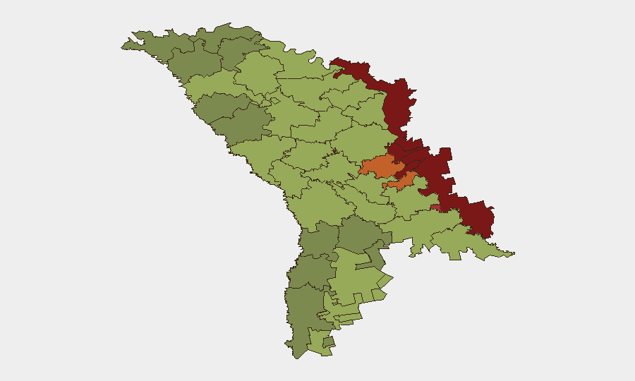
Situation Summary
Moldova faces a composite mid-range security environment shaped by three overlapping pressures: active Russian military spillover (15 airspace violations in 2026, debris on territory in 28 incidents since the war began), heightened governance and procedural vulnerabilities exposed by recent visa/screening lapses, and extreme weather (Code Red heat alert on 4 August) amplifying infrastructure and health strain. The capital and central regions remain functional but under persistent low-intensity stress; transnistrian and border zones carry substantially elevated risk. Overall trajectory is stable but brittle, dependent on Ukraine conflict containment and internal security procedure tightening.
Key Developments
- Strășeni District Court (central Moldova) – 4 Aug 2026: A 23-year-old detainee was fatally shot by a police officer during an escape attempt; authorities initiated a lethal-force investigation, signaling governance scrutiny and procedural review in law enforcement.
- Chișinău, Buiucani sector – 4 Aug 2026: Firefighters extinguished a residential attic fire; two residents treated for smoke/heat exposure and evacuated, consistent with broader infrastructure vulnerability under extreme conditions.
- Nationwide – 4 Aug 2026: General Inspectorate for Emergency Situations and meteorology services activated a "Code Red" extreme heat alert with emergency response measures, indicating health, fire, and infrastructure strain across the country.
- Chișinău (Foreign Ministry) – announced 3 Aug, ongoing: Moldova's Foreign Ministry issued a travel advisory warning of intensified Russian border checks, extended interrogations, and pressure on Moldovan male citizens (18–60) to sign Russian Defense Ministry contracts upon entry to Russia—elevated personal security and detention risk.
- Chișinău (government) – 4 Aug 2026: Prime Minister Vasile Tofan publicly condemned the entry of a Taliban Agriculture Ministry delegation as "embarrassing and unacceptable"; the government launched an internal review of visa and security procedures after the Foreign Ministry acknowledged visas were issued without intelligence service consultation.
- Nationwide – SIS/PCCOCS operations (reported last 48h): Security Intelligence Service and prosecutors' office PCCOCS blocked exports worth 21 million lei destined for the Russian military-industrial complex, disrupting sanctions-busting and illicit defense-trade schemes.
- Chișinău International Airport – 4 Aug 2026: FLYONE airline launched a new direct Chișinău–Geneva flight, altering international transit patterns and entry/exit screening flows.
Highest-Risk Areas
The Left Bank of the Dniester (risk 85), Dubăsari (82), and Bender (79) dominate the risk ranking and reflect transnistrian territorial separation, Russian military presence, and limited state control. Criuleni, Rezina, Taraclia, and Gagauzia (75, 58, 55, 54 respectively) represent border and ethnically mixed zones vulnerable to spillover, economic disruption, and cross-border pressure. The capital Chișinău (49), while lowest on the sub-national list, remains an administrative and political nerve center; mid-range risk reflects governance exposure (visa lapses, procedural gaps) and infrastructure strain under heat stress rather than direct conflict.
How GeoBit Would Assist
Security teams operate best with AOI Monitoring & Early Warning on transnistrian borders and critical infrastructure (airports, power, water, courts) to detect spillover and procedural breakdowns in near-real time. Intel Sweep and Telegram/X OSINT capture emerging enforcement actions (sanctions-busting, visa anomalies, military incursions) and sentiment shifts within security services and government. Routing & Network Analysis supports duty-of-care teams in real-time alternative exit planning if border delays, interrogations, or heat-related disruptions intensify.
7-Day Outlook
Extreme heat is expected to persist, increasing fire, health, and infrastructure incidents; governance scrutiny of visa and law-enforcement procedures will likely tighten further. Russian airspace violations and cross-border pressure on male travelers should be monitored as steady-state risks. No discrete conflict escalation is signaled, but procedural vulnerabilities and weather strain remain principal near-term drivers.
Highest-Risk Areas — Ranked
| # | State / Region | Risk |
|---|---|---|
| 1 | Administrative-Territorial Units of the Left Bank of the Dniester | 85 |
| 2 | Dubăsari | 82 |
| 3 | Bender | 79 |
| 4 | Criuleni | 75 |
| 5 | Rezina | 58 |
| 6 | Taraclia | 55 |
| 7 | Gagauzia | 54 |
| 8 | Căușeni | 53 |
| 9 | Soroca | 52 |
| 10 | Ștefan Vodă | 51 |
| 11 | Orhei | 50 |
| 12 | Chișinău | 49 |
Sources
Previous Daily Briefs
A new Moldova brief is written every day — each with its own risk map and downloadable CSV. Here's the last week; use the calendar to go further back.
📅 Browse every day by calendar →
Highlighted days have a brief. Tap a day for that day's map & analysis, or “csv” for that day's dataset ($5).
Atlas — our AI intelligence desk — emails them this snapshot personally. Nothing else, no list.