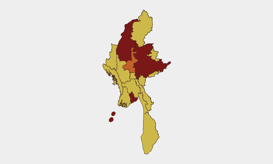
Situation Summary
Myanmar remains in active civil conflict with a composite threat score of 100 (rank #8 globally) driven by ongoing military operations, anti-government demonstrations, and cross-border friction. The past 48 hours have seen signals of anti-military protests, diplomatic tensions with regional neighbors, and small-arms combat along the India–Myanmar border, though precise incident locations and independent corroboration remain pending for most in-country events. The security environment continues to deteriorate across multiple sub-national zones, with Yangon and Shan State presenting the most acute risks to personnel and operations.
Key Developments
- Myanmar (countrywide), ~June 11, 2026 – Anti-military governance demonstrations reported across multiple locations; precise neighborhoods, attendance figures, and casualty data are not yet independently confirmed in open sources.
- Myanmar–Bangladesh border, ~June 11, 2026 – Deportation/expulsion of foreign nationals from Myanmar into Bangladesh recorded; identities and specific crossing points remain unconfirmed in dual-sourced reporting.
- Myanmar–Thailand border region, June 12, 2026 – Cross-border diplomatic friction involving Myanmar and Thai nationals escalated; operational context and locations not yet specified in public reporting.
- Manipur–Myanmar border, June 12, 2026 – Small-arms combat reported along the India–Myanmar frontier; geospatial precision and force composition are not available from current open-source corroboration.
- Countrywide (Myanmar), June 12, 2026 – Conventional military operations involving Myanmar armed forces and foreign military/diplomatic personnel signaled; specific theaters and rules of engagement remain unconfirmed.
- National media environment, June 12, 2026 – Military suppression of media activity, including public statements against outlets, recorded; specific outlets, charges, and locations are not independently verified.
- ASEAN–Myanmar, June 12, 2026 – Administrative sanctions imposed by ASEAN in response to Myanmar instability; scope and enforcement mechanisms not detailed in available reporting.
Highest-Risk Areas
Yangon (rank 1, risk score 100) and Shan State (rank 2, 90.1) are the primary drivers of national risk, followed by Sagaing Region (84.2) and Mandalay (74.7). Yangon's elevated risk reflects ongoing civil unrest, military presence, and disruption to civilian infrastructure; Shan State's risk profile is shaped by persistent armed-group activity, cross-border operations, and limited state control. Sagaing and Mandalay show sustained risk from military consolidation efforts and anti-government mobilization. All other tracked regions (Tanintharyi, Chin, Kachin, Wa, Magway, Rakhine, Naypyitaw) maintain a risk floor of 70, indicating pervasive underlying instability.
How GeoBit Would Assist
A corporate security team operating in Myanmar should leverage AOI Monitoring & Early Warning to establish persistent watch over high-risk zones (Yangon, Shan, Sagaing) with real-time alerting on military movement and civil unrest. Intel Sweep, multi-language OSINT, and social-media intelligence (X/Twitter, Telegram) can surface early signals of demonstrations, security-force activity, and border incidents 24–72 hours before mainstream confirmation. Battle mapping and force-structure tracking provide situational awareness of military deployments that may constrain personnel mobility or supply routes.
7-Day Outlook
The trajectory over the next week is likely toward sustained military operations in Shan, Sagaing, and Mandalay, coupled with intermittent anti-government protests in urban centers. Cross-border tensions with Thailand and Bangladesh may continue to create transit and diplomatic friction. Personnel and asset risk will remain elevated, particularly in Yangon and Shan State, with limited improvement expected absent a ceasefire signal or change in military posture.
Highest-Risk Areas — Ranked
| # | State / Region | Risk |
|---|---|---|
| 1 | Yangon | 100 |
| 2 | Shan State | 90.1 |
| 3 | Sagaing Region | 84.2 |
| 4 | Mandalay | 74.7 |
| 5 | Ayeyarwady | 70.4 |
| 6 | Tanintharyi Region | 70 |
| 7 | Chin | 70 |
| 8 | Kachin State | 70 |
| 9 | Wa State (Northern Region) | 70 |
| 10 | Magway | 70 |
| 11 | Rakhine | 70 |
| 12 | Naypyitaw Union Territory | 70 |
Sources
Previous Daily Briefs
A new Myanmar brief is written every day — each with its own risk map and downloadable CSV. Here's the last week; use the calendar to go further back.
📅 Browse every day by calendar →
Highlighted days have a brief. Tap a day for that day's map & analysis, or “csv” for that day's dataset ($5).