Situation Summary
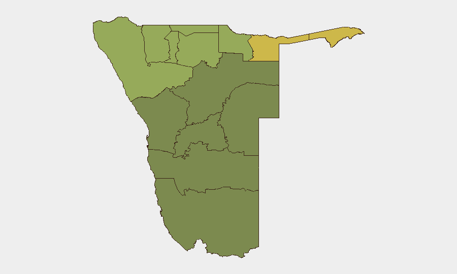
Namibia remains a low-threat environment globally (rank #127) with no discrete security incidents recorded in the current reporting window. The country's risk profile is concentrated in the north and northeast—particularly the Zambezi, Kavango, and Kunene regions—where resource scarcity, cross-border movement, and wildlife crime create persistent vulnerabilities. Current trajectory is stable; no acute instability indicators are present.
Key Developments
- Etosha National Park, Oshikoto region — 25 October 2026: Veld fires that burned approximately 16% of the park were contained following coordinated firefighting efforts by the Ministry of Environment, Namibian Defence Force, Ongava staff, conservancies, and local farm operators. All threatening fire fronts were suppressed by 19:00 on 24 October, reducing immediate risk to park infrastructure and surrounding communities.
- Etosha National Park (Okaukuejo/Opuwo area) — 25 October 2026: Authorities confirmed suppression of active fire lines, with standby teams remaining positioned pending final all-clear status. Fire extent and containment timelines suggest coordinated multi-agency response capability.
- Etosha National Park — 25 October 2026: An individual was arrested in connection with possession of poached oryx meat/biltong; reporting does not provide sufficient geographic precision or independent corroboration to assess broader poaching-network activity.
- Erongo region, Etango uranium project — 26 October 2026: Bannerman Energy and China National Nuclear Corporation Overseas jointly approved a US$353 million final investment decision for an open-pit uranium mine, targeting commissioning and first production in late 2028. This represents infrastructure development and strategic-resource expansion rather than an active security incident; however, it signals intensified international investment activity in northern mining zones.
Highest-Risk Areas
Northern and northeastern Namibia—Zambezi (risk 68), Kavango East (62), Kavango West (58), and Kunene (52)—drive the country's composite threat score. These regions share characteristics: proximity to Angola and Botswana borders, limited state presence, wildlife trafficking and poaching networks, and resource-scarcity pressures on mobile populations. The Etosha fire event this week, while successfully managed, underscores the vulnerability of critical infrastructure to environmental and human-induced disruption in the Oshikoto region (risk 48). Central and southern regions show substantially lower risk profiles.
How GeoBit Would Assist
Security teams operating in Namibia should leverage AOI Monitoring & Early Warning (persistent watch on high-risk zones such as Zambezi and Kavango East with automated alerting on environmental, crime, or movement signals) and Intel Sweep (continuous multi-language OSINT fusion across social media, local reporting, and event feeds to detect emerging poaching, trafficking, or cross-border incidents). GIS & Spatial Analysis and Satellite & Imagery Analysis capabilities support situational awareness of infrastructure (mining sites, parks, transport corridors) and early detection of fire, displacement, or unauthorized activity across remote northern regions where conventional reporting gaps are acute.
7-Day Outlook
No escalation indicators are present. Etosha fire containment and successful multi-agency coordination suggest operational resilience in response to environmental disruption. The uranium-project greenlight reflects stable investment climate in Erongo and may drive incremental security demand (workforce movement, equipment logistics) along transport corridors. Near-term focus should remain on routine wildlife-crime and border-movement monitoring in the north.
Highest-Risk Areas — Ranked
| # | State / Region | Risk |
|---|---|---|
| 1 | Zambezi | 68 |
| 2 | Kavango East | 62 |
| 3 | Kavango West | 58 |
| 4 | Kunene Region | 52 |
| 5 | Oshikoto | 48 |
| 6 | Ohangwena | 45 |
| 7 | Omusati | 42 |
| 8 | Oshana | 40 |
| 9 | Otjozondjupa | 35 |
| 10 | Erongo Region | 32 |
| 11 | Hardap | 28 |
| 12 | Omaheke | 25 |
Sources
Previous Weekly Briefs
A new Namibia brief is written every Monday, covering the week — each with its own risk map and downloadable CSV. Use the calendar to go further back.
- October 19, 2026
- October 12, 2026
- October 5, 2026
- September 28, 2026
- September 21, 2026
- September 14, 2026
- September 7, 2026
📅 Browse past briefs by calendar →
Highlighted days have a brief. Tap a day for that day's map & analysis, or “csv” for that day's dataset ($5).
Atlas — our AI intelligence desk — emails them this snapshot personally. Nothing else, no list.