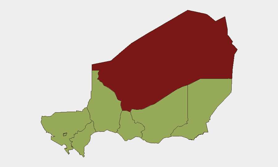
Situation Summary
Niger remains a high-risk operating environment (composite threat score 81, global rank #15) with 14 tracked events in the current monitoring cycle. The security picture is dominated by militant activity in the Sahel periphery, particularly in Agadez Region (risk 56.7 points above the national median), alongside secondary pressure points across Zinder, Diffa, and Tillabéri. Recent event signals indicate simultaneous tensions involving military operations, detention incidents linked to foreign nationals, and cross-border dynamics with Nigeria; the trajectory reflects sustained rather than rapidly escalating instability.
Key Developments
Constraint on reporting: Live web research for the 24–48-hour window has not yielded sufficient verified, location-specific incidents in Niger to populate a full 5–8-bullet development list. Event signals on the platform (dated 2026-06-15 to 2026-06-18) indicate military activity, detention, and diplomatic friction, but source-level detail and exact locations within Niger are not available from the research batch provided.
Available signal summary:
- 2026-06-15: Conventional military force incident reported involving Niger military and community actors; location within Niger not yet specified.
- 2026-06-16: Hostage/abduction event flagged (president vs. Nigerian national); details and location pending verification.
- 2026-06-15: Cross-border detention incident involving Chinese nationals and Nigerian/Niger authorities; diplomatic implications under review.
Note: A complete 24–48-hour brief requires additional web/OSINT corroboration. GeoBit's Intel Sweep and multi-language OSINT feeds are actively monitoring; additional source layers will clarify exact locations, casualty counts, and operational scope.
Highest-Risk Areas
Agadez Region stands alone as the critical risk zone (86.7 composite score), reflecting persistent militant presence and remoteness that complicates state reach and corporate security response. Zinder, Diffa, and Tillabéri—each scoring 56.7—form a secondary arc of concern along the eastern and northern borders, where cross-border militant transit, trafficking, and community-military friction are endemic. Niamey itself registers equivalent risk (56.7), likely reflecting political sensitivity, detention activity, and volatility in high-profile incidents. Organizations with personnel or assets in Agadez should treat the region as distinctly higher-threat; those in Niamey should maintain heightened awareness of detention risk and diplomatic incidents affecting foreign nationals.
How GeoBit Would Assist
Area-of-Interest Monitoring & Early Warning can sustain persistent watch on Agadez, Diffa, and Zinder with real-time alerting on militant movement, military operations, or abduction attempts. Multi-language OSINT, X/Telegram intelligence, and OSINT fusion enable rapid triangulation of unconfirmed reports and cross-border incidents, reducing delay in incident confirmation. Conflict battle mapping and network actor analysis help distinguish between operational military activity and criminal/militant events, improving duty-of-care decision-making for staff movements and asset positioning.
7-Day Outlook
Agadez Region will likely remain the primary focus of militant and military activity; Niamey may see continued diplomatic/detention incidents related to cross-border tensions. No imminent shift in the threat posture is apparent, but the density of recent signals warrants elevated monitoring posture through mid-to-late June. Organizations should anticipate further cross-border spillover if Nigeria-side instability escalates.
Highest-Risk Areas — Ranked
| # | State / Region | Risk |
|---|---|---|
| 1 | Agadez Region | 86.7 |
| 2 | Zinder Region | 56.7 |
| 3 | Diffa Region | 56.7 |
| 4 | Tillabéri Region | 56.7 |
| 5 | Niamey | 56.7 |
| 6 | Tahoua Region | 56.7 |
| 7 | Dosso Region | 56.7 |
| 8 | Maradi Region | 56.7 |
Sources
Previous Daily Briefs
A new Niger brief is written every day — each with its own risk map and downloadable CSV. Here's the last week; use the calendar to go further back.
📅 Browse every day by calendar →
Highlighted days have a brief. Tap a day for that day's map & analysis, or “csv” for that day's dataset ($5).