Situation Summary
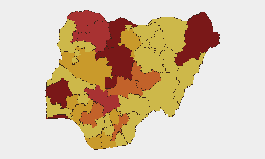
Nigeria remains at elevated threat level (#5 globally, composite score 100), with insurgency, banditry, and kidnapping as primary drivers across 662 tracked events. The security environment has deteriorated markedly over the past 48 hours, with coordinated attacks on security installations, university areas, and civilian populations coinciding with organized civil society calls for nationwide strikes and government accountability. Public confidence in federal security strategy is visibly eroding, creating compounding political and operational risk.
Key Developments
- Kuru, Plateau State (17 June, late evening): Armed gunmen attacked the National Institute for Policy and Strategic Studies (NIPSS) compound near Jos, killing two soldiers and one police officer in an hour-long gunfight before security forces contained the incident. The attack targeted a sensitive government research and training facility, indicating capability to strike hardened sites.
- Bokkos LGA, Plateau State (17 June): Gunmen suspected to be herdsmen launched coordinated attacks around Plateau State University; Nigerian Army, DSS, and NSCDC were deployed in response. The attacks heightened threat perception among student and staff populations and signal sustained pressure on educational infrastructure.
- Nationwide civil mobilization (17 June): The #EndBadGovernance movement and allied civil society groups called for a 48-hour nationwide strike and mass protests, demanding federal and state security-spending audits and citing rising kidnappings, terrorist attacks, and economic hardship. This represents organized political pressure on government and signals potential for disruption to commerce, transport, and service delivery.
- Media reporting surge (17 June): National broadcasters highlighted a recent spike in terrorist attacks, banditry, and abductions—including the reported kidnap and killing of a senior army officer—with analysts questioning the viability of current federal security doctrine. Negative sentiment and loss of confidence in institutional response are now prominent in public discourse.
- Regional commentary (17 June): Civil society analysts and media outlets emphasized that insecurity is now "widespread" across multiple regions rather than geographically contained, warning of escalating public anger and political instability if abductions and rural attacks continue unaddressed.
Highest-Risk Areas
Kaduna State (100), Oyo State (98.4), and Katsina State (96.1) are the composite-risk leaders, followed by Borno State (94.6) and the Federal Capital Territory (92.5)—a pattern reflecting both legacy insurgency zones (northeast) and emerging banditry/kidnapping pressure in the northwest and north-central regions. Notably, Oyo State's high ranking reflects spillover risk to southwest logistics and commercial hubs, while Kaduna's ranking reflects its position as a thoroughfare for both legitimate and illicit movement. The FCT's elevation reflects political sensitivity and the presence of government, diplomatic, and international-organization personnel.
How GeoBit Would Assist
Security and risk teams should employ AOI Monitoring & Early Warning to establish persistent surveillance of high-risk state capitals and transport corridors (especially Kaduna, Katsina, and Plateau routes); Intel Sweep and multi-language OSINT to track emerging bandit/herdsman faction communications and civil society messaging in real time; and Routing & Network Analysis to identify secure alternate routes and safe-haven facilities for personnel transits. Early Warning & Prediction capabilities would flag escalation signals—coordinated attacks, leadership statements, and protest organization—before operational impact.
7-Day Outlook
The 48-hour nationwide strike called for 17 June is likely to proceed and disrupt transport, fuel supply, and commerce, compounding security risks during mass gatherings and reducing police/military mobility. A second wave of attacks targeting security infrastructure or transport nodes is plausible within 7 days if bandits exploit civil unrest as cover. Federal government response and the narrative outcome of protests will be critical indicators of whether political pressure translates into operational security changes or further deterioration.
Highest-Risk Areas — Ranked
| # | State / Region | Risk |
|---|---|---|
| 1 | Kaduna State | 100 |
| 2 | Oyo State | 98.4 |
| 3 | Katsina State | 96.1 |
| 4 | Borno State | 94.6 |
| 5 | Federal Capital Territory | 92.5 |
| 6 | Lagos State | 90 |
| 7 | Zamfara State | 79.7 |
| 8 | Kogi State | 78.6 |
| 9 | Sokoto State | 76.1 |
| 10 | Nasarawa State | 75.4 |
| 11 | Ebonyi State | 75.4 |
| 12 | Edo State | 75 |
Sources
Previous Daily Briefs
A new Nigeria brief is written every day — each with its own risk map and downloadable CSV. Here's the last week; use the calendar to go further back.
📅 Browse every day by calendar →
Highlighted days have a brief. Tap a day for that day's map & analysis, or “csv” for that day's dataset ($5).