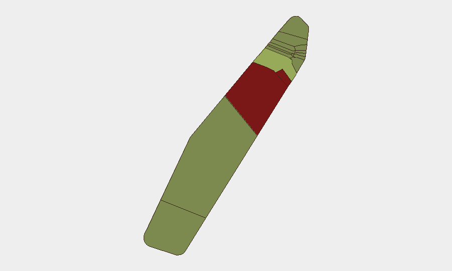
Situation Summary
Palau remains a low-threat environment with no verified security incidents, civil unrest, infrastructure disruption, or travel-risk events in the past 24–48 hours. The nation holds a composite threat score of 3 globally (rank #197) and continues to operate under stable conditions with no new advisory escalations from major government travel-warning systems. Current posture reflects routine low-level risk management across the archipelago, with no acute developments affecting corporate personnel or asset security.
Key Developments
- Nationwide, Palau – 16–18 July 2026: Multi-source open-source monitoring (news media, social platforms, government advisories, and regional security trackers) confirms no security incidents, civil unrest, serious crime, or infrastructure disruption within the past 24–48 hours.
- Koror (Koror State) – 16–18 July 2026: Social-media and OSINT monitoring identifies no protests, demonstrations, riots, or politically motivated violence in the capital or surrounding areas during the reporting window.
- Transport and utilities (nationwide) – 16–18 July 2026: Aviation, port, road, power, telecommunications, and water services show no disruptions affecting domestic or international access to Palau.
- Travel advisory posture (nationwide) – 16–18 July 2026: No new or escalated travel warnings have been issued by major government systems or multilateral bodies; Palau continues to be rated as low risk for international travel.
- Peleliu and Angaur states – 16–18 July 2026: Despite these states carrying the highest sub-national composite scores (92 and 88, respectively), routine monitoring detects no discrete incidents or new risk developments in the past 24–48 hours.
Highest-Risk Areas
Peleliu (risk 92) and Angaur (risk 88) are the primary drivers of elevated sub-national composite scores, though neither has reported acute security events in the current window. These rankings likely reflect historical conflict footprints (World War II sites and ongoing environmental/infrastructure challenges) and demographic or governance factors rather than active unrest. Koror (risk 45), the commercial and administrative hub, remains the third-highest-risk state but maintains significantly lower score than the outer states. Risk concentration in the outer states should not obscure the fact that no verified incidents are occurring; monitoring should remain calibrated to baseline conditions and trigger-event indicators rather than assume imminent escalation.
How GeoBit Would Assist
Security teams with personnel or assets in Palau can leverage GeoBit's AOI Monitoring & Early Warning capability to establish persistent watch on high-risk states (Peleliu, Angaur, Koror) with automated alerting for discrete incidents, civil unrest, or infrastructure disruption. Intel Sweep and OSINT fusion (multi-language search, social-media analysis, sentiment tracking, and multi-source corroboration) provide continuous baseline monitoring and rapid verification of emerging threats. Risk & Threat Assessment and conflict/maritime tracking enable duty-of-care teams to validate travel advisories, plan alternative routes via Routing & Network Analysis, and maintain situational awareness of regional developments (e.g., Indo-Pacific military activity) that could indirectly affect Palau's stability.
7-Day Outlook
No acute security developments are forecast for the next 7 days. Palau's stable political and security environment is expected to persist, with routine monitoring sufficient for corporate risk management. Seasonal weather patterns and regional geopolitical activity should remain the primary monitoring focus; no internal conflict, civil unrest, or infrastructure collapse indicators are evident in current threat reporting.
Highest-Risk Areas — Ranked
| # | State / Region | Risk |
|---|---|---|
| 1 | Peleliu | 92 |
| 2 | Angaur | 88 |
| 3 | Koror | 45 |
| 4 | Melekeok | 35 |
| 5 | Airai | 32 |
| 6 | Ngatpang | 28 |
| 7 | Ngeremlengui | 26 |
| 8 | Ngaraard | 25 |
| 9 | Ngardmau | 24 |
| 10 | Aimeliik | 23 |
| 11 | Ngiwal | 22 |
| 12 | Ngchesar | 21 |
Sources
Previous Daily Briefs
A new Palau brief is written every day — each with its own risk map and downloadable CSV. Here's the last week; use the calendar to go further back.
📅 Browse every day by calendar →
Highlighted days have a brief. Tap a day for that day's map & analysis, or “csv” for that day's dataset ($5).
Atlas — our AI intelligence desk — emails them this snapshot personally. Nothing else, no list.