Situation Summary
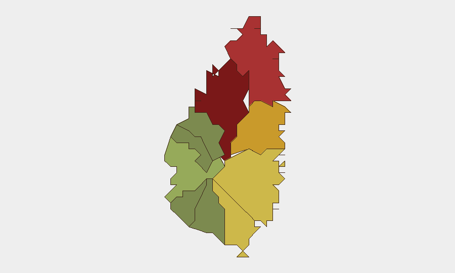
Saint Lucia remains classified as a Level 2 "Exercise Increased Caution" destination under the active U.S. Department of State travel advisory (updated 10 July 2026), driven by persistent violent crime including armed robbery, assault, burglary, and rape affecting both residents and tourist areas. No discrete security incidents have been verified in the last 24–48 hours via open-source intelligence; the threat landscape remains consistent with baseline conditions reflected in the advisory. The island's composite threat score of 14 reflects endemic crime concentrated in urban centers, particularly Castries (risk score 95), rather than active conflict, civil unrest, or terrorism.
Key Developments
- No verified Saint Lucia–specific security incidents documented in the last 24–48 hours across open web, social media (X/Twitter, Facebook), or local news channels with reliable timestamps. The most recent official change is the U.S. travel advisory refresh dated 10 July 2026 (outside the 48-hour window but currently operative).
- U.S. travel advisory remains in force (updated 10 July 2026). Level 2 status warns of violent and opportunistic crime across the island, including resort areas and tourist corridors. This is the primary current risk driver for international travel and corporate movement planning.
- Baseline crime threat persists in Castries and northern zones. Historical incidents (weeks to months old) document gang-affiliated shootings, armed robberies, and homicides clustered in Castries, Gros Islet, and Dennery; no new incidents have been time-stamped to the current 24–48 hour period.
- No acute political instability, civil unrest, labor actions, or public disorder reported in current monitoring windows. The security environment is characterized by chronic property and violent crime rather than mass mobilization or institutional breakdown.
- Limited real-time event feed activity. GeoBit's event signal tracking shows zero discrete incidents logged for Saint Lucia in the current analysis window, consistent with the absence of breaking news in commercial open-source channels.
Highest-Risk Areas
Castries (risk 95) and Gros Islet (risk 78) dominate the sub-national risk profile, driven by concentrated violent crime, gang presence, and armed robbery affecting both residential and commercial zones. Dennery (72) and Vieux Fort (68) follow as secondary hotspots linked to historical shooting incidents and homicides. Risk scores decline sharply in southwestern and western districts (Soufrière, Laborie, Choiseul, Anse La Raye), where crime rates are substantially lower and tourism infrastructure is lighter. Corporate teams should prioritize heightened situational awareness and access control protocols for personnel and assets in Castries and Gros Islet; southern and western deployments face materially lower baseline threat.
How GeoBit Would Assist
AOI Monitoring & Early Warning can establish persistent watch over high-risk districts (Castries, Gros Islet, Dennery) with automated alerting for new incidents, social-media indicators of unrest, or localized crime spikes. OSINT Fusion (X/Twitter, local news, police/emergency channels, and sentiment analysis) provides real-time intelligence on emerging crime trends, gang activity, and public safety announcements. Routing & Network Analysis enables secure alternative-route planning for personnel movement in and out of Castries, bypassing high-crime corridors during high-risk hours.
7-Day Outlook
No acute catalysts for rapid escalation are visible. The security environment is expected to remain consistent with the July 10 advisory—endemic urban crime with seasonal tourism fluctuations—barring unforeseen gang violence, political friction, or external shocks. Continuous monitoring of Castries and Gros Islet remains warranted for duty-of-care compliance.
Highest-Risk Areas — Ranked
| # | State / Region | Risk |
|---|---|---|
| 1 | Castries | 95 |
| 2 | Gros Islet | 78 |
| 3 | Dennery | 72 |
| 4 | Vieux Fort | 68 |
| 5 | Micoud | 65 |
| 6 | Soufrière | 42 |
| 7 | Laborie | 38 |
| 8 | Choiseul | 35 |
| 9 | Anse La Raye | 28 |
| 10 | Canaries | 12 |
Sources
Previous Daily Briefs
A new Saint Lucia brief is written every day — each with its own risk map and downloadable CSV. Here's the last week; use the calendar to go further back.
📅 Browse every day by calendar →
Highlighted days have a brief. Tap a day for that day's map & analysis, or “csv” for that day's dataset ($5).
Atlas — our AI intelligence desk — emails them this snapshot personally. Nothing else, no list.