Situation Summary
Samoa remains a low-threat environment with no acute security incidents reported in the last 24–48 hours. The country ranks #143 globally in composite threat, with routine baseline risks confined to petty crime and occasional violent assault in urban centers. The dengue outbreak continues as the primary non-security risk factor, straining healthcare capacity. The security posture is stable with no indicators of imminent civil unrest, political instability, or infrastructure disruption.
Key Developments
- Nationwide – 17 July 2026: U.S. State Department public statement issued; no specific incident disclosed in available open-source reporting. Australian Smartraveller advisory reviewed and reaffirmed as current, with no new security warnings.
- Nationwide – 15 July 2026: Samoa Police Service issued an investigation notice; details remain limited in public channels, but no corroborated link to corporate security or travel-risk incidents identified.
- Apia and urban centers – ongoing through mid-July: Baseline petty theft, robbery, and occasional violent assault (including sexual assault) continue in nightlife and hospitality venues, particularly after hours. Emergency services remain under-resourced but no incident clustering reported in the last 48 hours.
- Nationwide – ongoing through mid-July: Dengue outbreak persists with documented pressure on Ministry of Health capacity and emergency medical resources. Strict mosquito-bite precautions and pre-departure vaccination status remain strongly recommended for all personnel.
- Nationwide – 15 July 2026: Samoa public statement issued; content not separately detailed in available intelligence, but consistent with routine administrative or health communication.
- American Samoa – 17 July 2026: U.S. territory public statement released; geographically separate from independent Samoa but may reflect regional health or administrative updates relevant to the broader Pacific.
No credible security incidents, civil disturbances, or infrastructure failures are recorded in Samoa proper for the 24–48 hour window.
Highest-Risk Areas
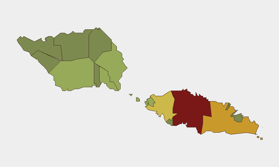
Tuamasaga (risk 85) and Ātua (risk 71) account for the majority of tracked risk in Samoa, driven primarily by urban crime concentration in and around Apia (Tuamasaga) and secondary population centers. Aʻana (62) and Aiga-i-le-Tai (55) represent moderate exposures tied to baseline crime and limited emergency-services capacity in smaller towns. Rural and outer districts (Vaisigano, Vaʻa-o-Fonoti) show substantially lower risk profiles, reflecting lower population density and reduced crime reporting. Corporate assets and personnel should prioritize situational awareness and duty-of-care protocols in Tuamasaga, particularly after-hours movement in Apia's commercial and hospitality districts.
How GeoBit Would Assist
AOI Monitoring & Early Warning with persistent watch on Apia and secondary urban centers would provide real-time alerting if crime clusters, public-health deterioration, or political signals emerge. Multi-language OSINT & Intel Sweep across Samoan and regional media, radio SIGINT, and social-media feeds (X, Telegram) would capture early indicators of civil unrest or health-system breakdown ahead of official advisories. GIS & Spatial Analysis layered with demographic and crime data would enable dynamic risk-mapping by district and time-of-day, supporting personnel routing and incident response planning.
7-Day Outlook
No material change in the security baseline is forecast over the next seven days. Dengue circulation is expected to persist, reinforcing the need for continuous health risk mitigation. Routine petty crime and occasional violent assault will remain the primary duty-of-care concern in urban areas; no indicators suggest spike or organized criminal activity.
Highest-Risk Areas — Ranked
| # | State / Region | Risk |
|---|---|---|
| 1 | Tuamasaga | 85 |
| 2 | Ātua | 71 |
| 3 | Aʻana | 62 |
| 4 | Aiga-i-le-Tai | 55 |
| 5 | Faʻasaleleaga | 48 |
| 6 | Palauli | 42 |
| 7 | Satupaʻitea | 38 |
| 8 | Gagaʻemauga | 35 |
| 9 | Gagaʻifomauga | 32 |
| 10 | Vaisigano | 28 |
| 11 | Vaʻa-o-Fonoti | 23 |
Previous Daily Briefs
A new Samoa brief is written every day — each with its own risk map and downloadable CSV. Here's the last week; use the calendar to go further back.
📅 Browse every day by calendar →
Highlighted days have a brief. Tap a day for that day's map & analysis, or “csv” for that day's dataset ($5).
Atlas — our AI intelligence desk — emails them this snapshot personally. Nothing else, no list.