Situation Summary
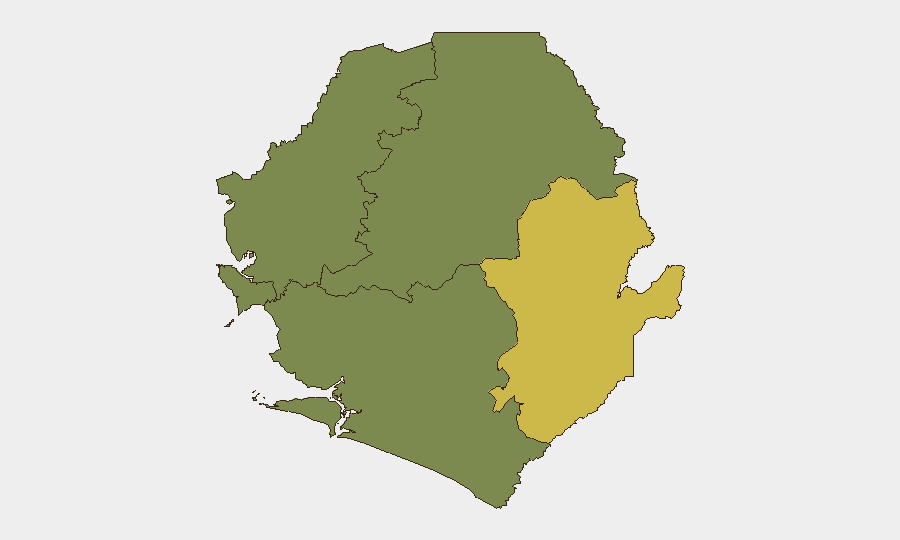
Sierra Leone remains at composite threat rank #115 globally with a score of 8, reflecting a relatively low but localized risk environment. No major security incidents, civil unrest, infrastructure disruptions, or cross-border incidents have been documented in open sources over the past 24–48 hours. The country's risk profile is heavily concentrated in the Eastern Province, which accounts for the majority of tracked threat activity, while Western Area (Freetown and surroundings) carries moderate residual concern. Overall trajectory remains stable absent new triggering events.
Key Developments
- 2026-06-26 · Freetown (Western Area). A public statement was issued; full content and issuer have not yet been corroborated in independent sources, limiting operational detail at this time.
- 2026-06-26 · National level. An appeal was filed by voters regarding political party conduct; routine electoral-cycle engagement with no reported confrontation or disruption.
- Absence of reported incidents (24–48h window). No credible open-source reporting documents protests, riots, armed clashes, major crime events, or transport/port disruptions in Freetown, provincial centers, or border areas as of 26 June 2026.
- No updated diplomatic advisories. Major embassies and multilateral bodies have not issued new security or travel alerts for Sierra Leone in the June 24–26 window; recent alerts from this period focus on other regions (e.g., Venezuela).
*Note: The two signal events flagged by GeoBit (public statement, voter appeal) reflect routine political activity rather than conflict or instability triggers. No corroborating details are yet available in multi-source reporting.*
Highest-Risk Areas
The Eastern Province dominates Sierra Leone's risk landscape with a composite score of 68—nearly double the Western Area's score of 35 and substantially higher than the Northern, North Western, and Southern provinces, all of which register minimal active threat signals. This concentration suggests that trafficking, resource-extraction crime, border instability, or organized activity in the eastern interior remains the primary driver of corporate and diplomatic concern. Western Area (Freetown, port, major business hubs) carries secondary but material risk, likely tied to urban crime, political tension, and critical infrastructure exposure. Northern and Southern provinces currently show negligible tracked activity.
How GeoBit Would Assist
Corporate security teams should use AOI Monitoring & Early Warning on Freetown and the Eastern Province to detect emerging unrest, crime spikes, or political mobilization in real time. OSINT fusion (X/Twitter, local radio/Telegram channels, and multi-language search) will surface police statements, eyewitness accounts, and civil-society alerts that often precede formal news reporting. Election Monitoring and Network & Actor Analysis capabilities enable tracking of political-party messaging and informal networks during periods of electoral activity, reducing surprise and enabling duty-of-care escalation if rhetoric or activity turns confrontational.
7-Day Outlook
No significant escalation is anticipated in the near term based on current open-source signals. Routine political activity and voter engagement should continue without major disruption. Security teams should maintain standard vigilance on the Eastern Province and Western Area, with heightened sensitivity to any shift in political temperature or localized crime reporting; tasking on-the-ground assets for confirmation of stability in key cities and transport corridors remains prudent given limited real-time visibility.
Highest-Risk Areas — Ranked
| # | State / Region | Risk |
|---|---|---|
| 1 | Eastern Province | 68 |
| 2 | Western Area | 35 |
| 3 | North West Province, Sierra Leone | 0 |
| 4 | Northern Province, Sierra Leone | 0 |
| 5 | Southern Province, Sierra Leone | 0 |
Sources
Previous Daily Briefs
A new Sierra Leone brief is written every day — each with its own risk map and downloadable CSV. Here's the last week; use the calendar to go further back.
📅 Browse every day by calendar →
Highlighted days have a brief. Tap a day for that day's map & analysis, or “csv” for that day's dataset ($5).